Mountain refuge Refugio de Montaña de la Sierra de Valdespino

We have it listed in the app!


            Mountain refuge Refugio de Montaña de la Sierra de Valdespino in refugio de montaña de la sierra de valdespino, camino de moncoubo, porto, zamora, castilla y león, españa
Five orange stars in a horizontal row representing a five-star rating.

Refugio de Montaña de la Sierra de Valdespino

Lat: 42.162xxx – Lon: -6.836xxx
📍 refugio de montaña de la sierra de valdespino, camino de moncoubo, porto, zamora, castilla y león, españa
Refugio de Montaña de la Sierra de Valdespino

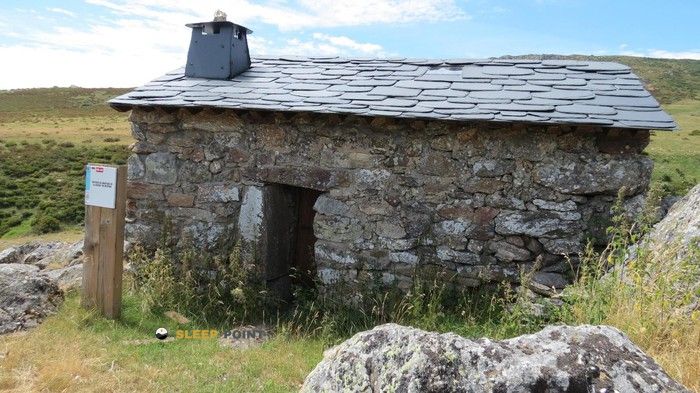
With a privileged location in refugio de montaña de la sierra de valdespino, camino de moncoubo, porto, zamora, castilla y león, españa, the Refugio de Montaña de la Sierra de Valdespino refuge awaits you at 1610 meters of altitude. Note its position (42.162, -6.836) before starting your route through the mountain range or massif.

See more
See more
Usuario

Lucas Martinez

Premium user

Live weather: Refugio de Montaña de la Sierra de Valdespino

Live weather report for Refugio de Montaña de la Sierra de Valdespino: current 7.5°C at 1610 meters (feels like 4.5°C). Wind at 11.1 km/h with gusts that may reach 48.2 km/h. The freezing level is at 4510 m and the maximum temperature will be 10.7°C.
Temperature

7.5°C

Feels like: 4.5°C
Wind

11.1 km/h

Gusts: 48.2 km/h
Freezing level 0°

4510 m

Snow line
Sky & UV

UV 0

Clouds: 97%

Next 48 hours evolution

7-day forecast

04/06
10.7° 6.1°
0.2 mm 21.7 km/h UV máx: 8.15
06:52 21:58
05/06
13.9° 3.1°
0 mm 16.6 km/h UV máx: 8.2
06:51 21:59
06/06
16° 7.3°
0 mm 12.4 km/h UV máx: 8.2
06:51 22:00
07/06
19.3°
0 mm 13 km/h UV máx: 8.05
06:51 22:00
08/06
17.3° 9.8°
0 mm 17.3 km/h UV máx: 8.1
06:51 22:01
09/06
19.8° 8.3°
0 mm 8.9 km/h UV máx: 7.95
06:50 22:02
10/06
22.3° 8.5°
0 mm 10.1 km/h UV máx: 7.95
06:50 22:02

Planning a route through the mountains of Porto requires support points.

At 1610 meters of altitude, the environment offers a natural transition between the slopes of the Sierra de Valdespino and the most exposed crest areas. This enclave allows to manage the physical effort before facing the pedestal grounds or reach the upper cords of the Sierra Segundo where the relief becomes more technical and the climate more severe.

Strategic support in the Sanabria Mountain

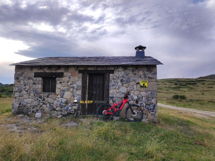
Its location is tactic for those who travel the GR 84 especially in the stages that connect the valleys of glacial origin to the altiplanices. The mountain shelter facilitates access to summits such as the Moncalvo or Pico dos Poleiros , serving as visual reference on itineraries that travel the Senda de la Dam Rota or the descents towards the Tera Canyon .

The orography of this Zamoran region requires a precise reading of the map and the passing times. By being at an intermediate point, this construction helps to divide demanding days, allowing the mountaineers to assess the conditions of the land before entering the most isolated areas of the high Sanabresa mountain.

As the nearest water sources are several kilometres away, it is essential to ensure prior water supply. The total autonomy in terms of equipment and food is necessary, as the status and services of these shelter points may vary according to season and maintenance.

Hiking routes from the refuge

11

Senda de la Presa Rota

↔ Variable distance
3

Senda de la Cueva de San Martín y Cañón del Tera

↔ Variable distance
4

Senda de los Cañones del Cárdena y Segundera

↔ Variable distance
GR 84

Montaña de Sanabria - Etapa 5

↔ Variable distance
GR 84

Montaña de Sanabria - Etapa 4

↔ Variable distance
GR 84

Montaña de Sanabria - Etapa 3

↔ Variable distance
TRC-012-R3

Trail Running Porto de Sanabria

↔ Variable distance
TRC-012-R2

Trail Running Porto de Sanabria

↔ Variable distance

Nearby peaks

Pico dos Poleiros

2012 m
Lat: 42.1885 Lon: -6.8238

Alto de Bouza

1720 m
Lat: 42.1846 Lon: -6.774

Peña del Buey

1669 m
Lat: 42.1372 Lon: -6.8234

Alto del Suelto

1751 m
Lat: 42.1518 Lon: -6.7757

Moncalvo

2044 m
Lat: 42.1982 Lon: -6.8089

Alto das Chás/Alto de las Chanas

1670 m
Lat: 42.1427 Lon: -6.8094

Nearby water fountains

Fuente

5.22 Km
Lat: 42.1427 Lon: -6.8094

Fuente

5.24 Km
Lat: 42.1427 Lon: -6.8094

Fuente de Vega de Conde

7.12 Km
Lat: 42.1427 Lon: -6.8094

Fuente

7.97 Km
Lat: 42.1427 Lon: -6.8094

Fuente de la Majada de Trefacio

7.98 Km
Lat: 42.1427 Lon: -6.8094

Fuente Peña-Puente

8.47 Km
Lat: 42.1427 Lon: -6.8094

Fuente

9.13 Km
Lat: 42.1427 Lon: -6.8094

Fuente

9.28 Km
Lat: 42.1427 Lon: -6.8094
FAQ

Frequently asked questions

Pregunta frecuente
At what exact altitude is the Refugio de Montaña de la Sierra de Valdespino refuge located?
The Refugio de Montaña de la Sierra de Valdespino refuge is located at an altitude of 1610 meters above sea level, in the natural surroundings of refugio de montaña de la sierra de valdespino, camino de moncoubo, porto, zamora, castilla y león, españa.
Pregunta frecuente
What are the GPS coordinates of the Refugio de Montaña de la Sierra de Valdespino refuge?
To locate the Refugio de Montaña de la Sierra de Valdespino refuge on your GPS or map, use the following coordinates: Latitude 42.162 and Longitude -6.836.
Pregunta frecuente
Is it necessary to carry a GPS to reach the Refugio de Montaña de la Sierra de Valdespino refuge?
It is always highly recommended to carry a GPS device, a route track, or a topographic map in the mountains. You can use the coordinates 42.162, -6.836 to locate this refuge precisely.
More areas

Other areas

Collaborative

Together we improve

image

Send your photos

You can upload photos of shelters and update their status so other users know if they can go there.

Get started
Get started
image

Rate the shelter

Leave your comments to rate the shelter’s condition. In the mountains, we look after each other.

Get started
Get started
image

Add new ones

Did we miss any? Publish the shelters you know so everyone can use them.

Get started
Get started
Download for free from the Apple App Store and Play Store.

Download the app and start looking for the shelter of your next adventure

Aplicación móvil para encontrar refugios de montaña donde dormir
Aplicación móvil para encontrar refugios de montaña donde dormir.
Mapa interactivo de refugios de montaña en los Pirineos dentro de la app
Mapa de refugios de montaña para senderismo y trekking en la app.
Pantalla con información de refugio de montaña con altitud capacidad y servicios
Pantalla con información de refugio de montaña con altitud capacidad y servicios.
Detalles de refugio de montaña con servicios y meteorología en aplicación móvil
Detalles de refugio de montaña con servicios y meteorología en aplicación móvil.
Aplicación para explorar refugios de montaña mediante mapa interactivo
Aplicación para explorar refugios de montaña mediante mapa interactivo.
Ficha completa de refugio de montaña con opiniones y servicios
Ficha completa de refugio de montaña con opiniones y servicios.
Información detallada de refugio en app para montañeros
Información detallada de refugio en app para montañeros.
Listado de refugios de montaña para senderismo y trekking
Listado de refugios de montaña para senderismo y trekking.
Explorar refugios de montaña desde una aplicación móvil
Explorar refugios de montaña desde una aplicación móvil.