Mountain refuge Refuge de la Fontaine Hunoltstein

We have it listed in the app!


            Mountain refuge Refuge de la Fontaine Hunoltstein in refuge de la fontaine hunoltstein, chemin du kessel, sainte-marie-aux-mines, colmar-ribeauvillé, alto rin, collectivité européenne d'alsace, gran este, francia metropolitana, 68160, francia
Five orange stars in a horizontal row representing a five-star rating.

Refuge de la Fontaine Hunoltstein

Lat: 48.197xxx – Lon: 7.148xxx
📍 refuge de la fontaine hunoltstein, chemin du kessel, sainte-marie-aux-mines, colmar-ribeauvillé, alto rin, collectivité européenne d'alsace, gran este, francia metropolitana, 68160, francia
Refuge de la Fontaine Hunoltstein

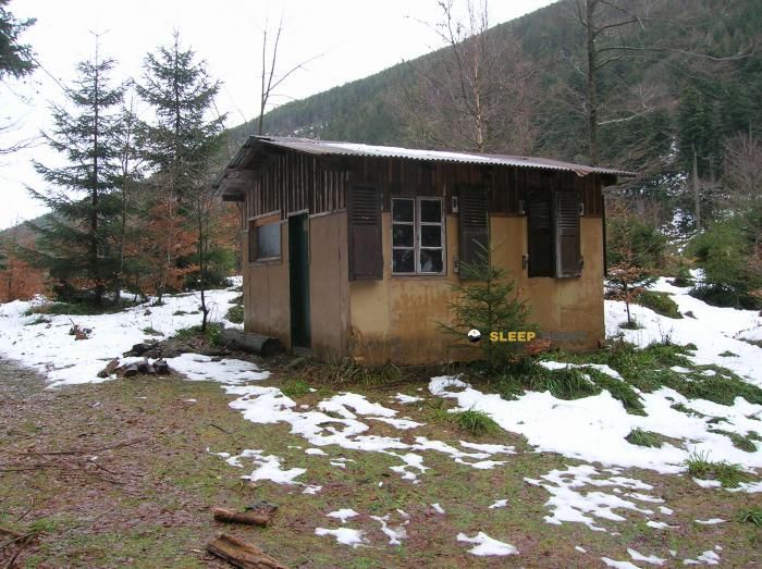
Discover the Refuge de la Fontaine Hunoltstein refuge, an alpine shelter located at 940 meters in the area of refuge de la fontaine hunoltstein, chemin du kessel, sainte-marie-aux-mines, colmar-ribeauvillé, alto rin, collectivité européenne d'alsace, gran este, francia metropolitana, 68160, francia. Whether you are on a multi-day trek or a day hike, this point (48.197, 7.148) will provide the peace and shelter you seek in the mountains.

See more
See more
Usuario

Lucas Martinez

Premium user

Live weather: Refuge de la Fontaine Hunoltstein

Live weather from Refuge de la Fontaine Hunoltstein shows 12.2°C and skies with 100% cloudiness. Wind is blowing at 31.9 km/h, lowering the feels-like temperature to 7.2°C. For high-altitude trips, the freezing level is at 3140 m and the maximum temperature will be 13.9°C.
Temperature

12.2°C

Feels like: 7.2°C
Wind

31.9 km/h

Gusts: 93.2 km/h
Freezing level 0°

3140 m

Snow line
Sky & UV

UV 0.7

Clouds: 100%

Next 48 hours evolution

7-day forecast

04/06
13.9° 9.5°
5.5 mm 31.6 km/h UV máx: 4.05
05:33 21:26
05/06
12.8° 7.6°
2.5 mm 22.3 km/h UV máx: 5.95
05:33 21:26
06/06
16.3° 7.7°
0.6 mm 14.9 km/h UV máx: 7
05:32 21:27
07/06
16.9° 8.9°
0 mm 15.9 km/h UV máx: 5.6
05:32 21:28
08/06
22.3° 8.8°
1.2 mm 11.8 km/h UV máx: 6.55
05:31 21:29
09/06
14.3° 8.6°
2.1 mm 16.2 km/h UV máx: 4.75
05:31 21:30
10/06
14° 5.5°
0 mm 10 km/h UV máx: 6.6
05:31 21:30

In this sector of the Vosgos, the presence of itineraries such as the GR 5 , GR 531 and GR 532 place this mountain shelter in a useful area for passing days, links between routes and stages that require a good reading of the map before leaving. Its location, on the heights above Sainte-Marie-aux-Mines , fits better as a support within a journey or a long route than as a point to which to trust all the logistics. It can also be used as a reference for moving through local variants and memory paths that go through these Upper Rhine forest lomas.

At about 940 meters of altitude, the land combines forest environment and rounded relief of half mountain, but very close to the sea are the Petit Brézouard and Grand Brézouard which raise the mountainous character of the area and help to focus on the divisive. This transition between forest, high slopes and soft crests makes weather and visibility change quickly, especially if the day links several cords. There is a source about 800 meters away, reasonable distance to plan the water but not to take it for granted without margin. It is therefore necessary to face the route with sufficient autonomy and to consider the shelter as a mountain support, not as a resource that can always be reached or that can always be dependent on the changing time, orientation or state of the land.

Hiking routes from the refuge

GR 5

GR 5 Vosges, Le Donon - Ballon d'Alsace

↔ Variable distance
GR 532

GR 532

↔ 503 km
Local

Tour du Lac Blanc

↔ Variable distance
GR 531

GR 531

↔ 376 km
Local

Les Chemins de la Mémoire

↔ 8,1 km
4.2

Variante Carrefour des Cerfs - Relais TV

↔ Variable distance
11

La Croix des Suédois

↔ 8 km
10

La Tête du Violu

↔ 13.5 km

Nearby peaks

Grand Brézouard

1229 m
Lat: 48.1895 Lon: 7.15

Tête des Faux

1208 m
Lat: 48.1542 Lon: 7.1151

Hirzberg

1140 m
Lat: 48.2117 Lon: 7.1881

Petit Brézouard

1203 m
Lat: 48.1944 Lon: 7.156

Rehberg

1141 m
Lat: 48.2029 Lon: 7.1701

Le Champ du Diable

1136 m
Lat: 48.2045 Lon: 7.1935

Le Pain de Sucre

807 m
Lat: 48.2381 Lon: 7.1505

Tête du Violu

993.5 m
Lat: 48.2249 Lon: 7.1265

Nearby water fountains

Fuente

798 m
Lat: 48.2249 Lon: 7.1265

Fuente

3.65 Km
Lat: 48.2249 Lon: 7.1265

Fuente

3.68 Km
Lat: 48.2249 Lon: 7.1265

Fuente

5.02 Km
Lat: 48.2249 Lon: 7.1265

Fuente

5.4 Km
Lat: 48.2249 Lon: 7.1265

Fuente

5.46 Km
Lat: 48.2249 Lon: 7.1265

Fuente

5.56 Km
Lat: 48.2249 Lon: 7.1265

Fuente

5.65 Km
Lat: 48.2249 Lon: 7.1265
FAQ

Frequently asked questions

Pregunta frecuente
Are there other mountain refuges near Refuge de la Fontaine Hunoltstein?
Yes, nearby you can find other options to spend the night or take shelter. El refugio más próximo es el Refuge du Brézouard, que se encuentra a aproximadamente 0.5 km de distancia.
Pregunta frecuente
At what exact altitude is the Refuge de la Fontaine Hunoltstein refuge located?
The Refuge de la Fontaine Hunoltstein refuge is located at an altitude of 940 meters above sea level, in the natural surroundings of refuge de la fontaine hunoltstein, chemin du kessel, sainte-marie-aux-mines, colmar-ribeauvillé, alto rin, collectivité européenne d'alsace, gran este, francia metropolitana, 68160, francia.
Pregunta frecuente
What are the GPS coordinates of the Refuge de la Fontaine Hunoltstein refuge?
To locate the Refuge de la Fontaine Hunoltstein refuge on your GPS or map, use the following coordinates: Latitude 48.197 and Longitude 7.148.
More areas

Other areas

Collaborative

Together we improve

image

Send your photos

You can upload photos of shelters and update their status so other users know if they can go there.

Get started
Get started
image

Rate the shelter

Leave your comments to rate the shelter’s condition. In the mountains, we look after each other.

Get started
Get started
image

Add new ones

Did we miss any? Publish the shelters you know so everyone can use them.

Get started
Get started
Download for free from the Apple App Store and Play Store.

Download the app and start looking for the shelter of your next adventure

Aplicación móvil para encontrar refugios de montaña donde dormir
Aplicación móvil para encontrar refugios de montaña donde dormir.
Mapa interactivo de refugios de montaña en los Pirineos dentro de la app
Mapa de refugios de montaña para senderismo y trekking en la app.
Pantalla con información de refugio de montaña con altitud capacidad y servicios
Pantalla con información de refugio de montaña con altitud capacidad y servicios.
Detalles de refugio de montaña con servicios y meteorología en aplicación móvil
Detalles de refugio de montaña con servicios y meteorología en aplicación móvil.
Aplicación para explorar refugios de montaña mediante mapa interactivo
Aplicación para explorar refugios de montaña mediante mapa interactivo.
Ficha completa de refugio de montaña con opiniones y servicios
Ficha completa de refugio de montaña con opiniones y servicios.
Información detallada de refugio en app para montañeros
Información detallada de refugio en app para montañeros.
Listado de refugios de montaña para senderismo y trekking
Listado de refugios de montaña para senderismo y trekking.
Explorar refugios de montaña desde una aplicación móvil
Explorar refugios de montaña desde una aplicación móvil.