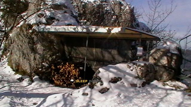
Mountain refuge Métairie de Dombresson-Frienisberg
We have it listed in the app!
We have it listed in the app!


Discover the vastness of métairie de dombresson (frienisberg), 1, métairie-de-frienisberg, villiers, nods, neuchâtel, 2518, suiza by spending the night at the Métairie de Dombresson-Frienisberg refuge. It sits at 1415 meters, offering a unique balcony over the natural landscape. Find it on the map at latitude 47.121 and longitude 7.029.
10.3°C
Feels like: 7.4°C17.4 km/h
Gusts: 57.2 km/h3210 m
Snow lineUV 1.7
Clouds: 100% 15.9 mm
 23.9 km/h
 UV máx: 5.1
 05:38
05:38
 21:22
2.8 mm
17.3 km/h
UV máx: 4.7
05:38
21:22
0.1 mm
17.9 km/h
UV máx: 7.25
05:37
21:23
0 mm
13.7 km/h
UV máx: 6.15
05:37
21:24
0.3 mm
17.7 km/h
UV máx: 5.75
05:36
21:25
2.1 mm
19.6 km/h
UV máx: 2.2
05:36
21:25
0 mm
10.1 km/h
UV máx: 7.1
05:36
21:26
21:22
2.8 mm
17.3 km/h
UV máx: 4.7
05:38
21:22
0.1 mm
17.9 km/h
UV máx: 7.25
05:37
21:23
0 mm
13.7 km/h
UV máx: 6.15
05:37
21:24
0.3 mm
17.7 km/h
UV máx: 5.75
05:36
21:25
2.1 mm
19.6 km/h
UV máx: 2.2
05:36
21:25
0 mm
10.1 km/h
UV máx: 7.1
05:36
21:26
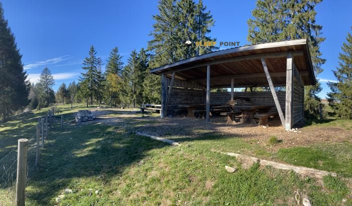
In this part of the massif of Chasseral , several hiking routes cross or pass near the shelter, including the Swiss trail of E4 . This gives you interest as a reference to the map rather than as a simple, isolated coat: it allows you to fit in a day of passage, to divide a journey through the ridge or to resolve a change of itinerary between the roads that go up from the environment of Nods and those that link with sectors like Le Pâquier or Diesse.
The position of the Métairie de Dombresson-Frienisberg At 1415 metres, it is located on a medium and high Jurasian mountain, open and very conditioned by weather. Very close appears Chasseral Ouest and within walking distance are the same Chasseral and Petit Chasseral , tops that help to understand the character of the place: an area of high loops, broad cords and orientation that can be complicated when fog or time changes. In this context, the shelter works well as a reference point to navigate the divisive and not lose the reading of the relief.
It also makes sense within longer routes along the Jura arc, as it is not disconnected from the network of trails, but integrated into it. It should not be interpreted as a basis for technical ascension, but as a support for crossing routes, crest marches and links between sides. The proximity of summits and steps makes the accumulated gap much dependent on the chosen route, although the environment is still exposed to the wind and rapid changes in visibility.
In practical planning, water deserves attention. There is a source about 850 meters away, reasonable distance but sufficient not to take for granted the immediate supply next to the shelter. If it is raised as an intermediate point in a long day, it is necessary to go out with autonomy and to review first the real state of access and water points, especially on cold days, with fog or out of season.


📏 5.4 Km
⛰️ 1245 m

📏 10.2 Km
⛰️ 1389 m

📏 10.7 Km
⛰️ 1320 m

📏 11.1 Km
⛰️ 1130 m
📏 13.7 Km
⛰️ 1079 m

📏 13.8 Km
⛰️ 553 m

📏 13.8 Km
⛰️ 548 m
📏 14 Km
⛰️ 1097 m
Download the app and start looking for the shelter of your next adventure


Find a place to sleep before night falls.


