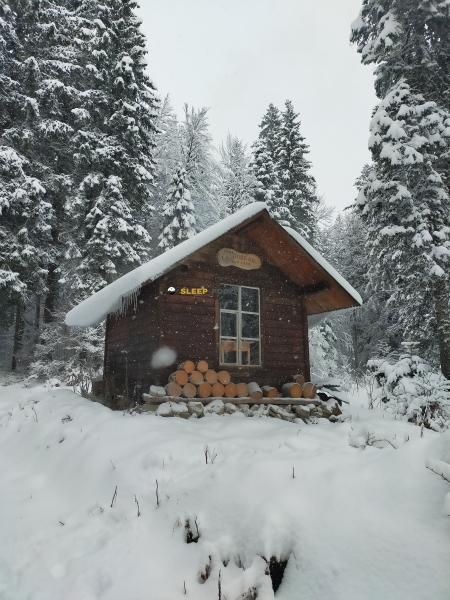
Mountain refuge La Réserve
We have it listed in the app!
We have it listed in the app!


Prepare your backpack and head to refuge de la réserve, chemin du bas du risoux, le chenit, district du jura-nord vaudois, valdia, 1348, suiza. There you will find the La Réserve refuge at 1203 meters of elevation. An essential stop along the way (Lat: 46.594, Lon: 6.176) for any mountain enthusiast.
9.1°C
Feels like: 6.9°C8.4 km/h
Gusts: 29.5 km/h3910 m
Snow lineUV 0
Clouds: 100% 18.5 mm
 18.8 km/h
 UV máx: 5.6
 05:44
05:44
 21:23
1.3 mm
16.6 km/h
UV máx: 6.1
05:43
21:24
0 mm
19.7 km/h
UV máx: 7.35
05:43
21:24
0 mm
11.9 km/h
UV máx: 6.75
05:42
21:25
3.75 mm
14.2 km/h
UV máx: 6.9
05:42
21:26
12.6 mm
15.5 km/h
UV máx: 3.7
05:42
21:26
0 mm
10.9 km/h
UV máx: 7.25
05:41
21:27
21:23
1.3 mm
16.6 km/h
UV máx: 6.1
05:43
21:24
0 mm
19.7 km/h
UV máx: 7.35
05:43
21:24
0 mm
11.9 km/h
UV máx: 6.75
05:42
21:25
3.75 mm
14.2 km/h
UV máx: 6.9
05:42
21:26
12.6 mm
15.5 km/h
UV máx: 3.7
05:42
21:26
0 mm
10.9 km/h
UV máx: 7.25
05:41
21:27
The environment La Réserve it moves more in soft relief key and mountain forest than in abrupt high mountain, within the sector of Le Chenit and the Joux valley, very close to the border strip between Switzerland and France. At 1203 meters, its location fits into a day where the land forces less by extreme level than by the management of the route, the orientation and continuity between tracks, forest roads and open lomas.
The reference of the chemin du Bas du Risoux helps to place it in an area where the forest mass of the Risoux greatly marks the reading of the landscape. In this context, the shelter works primarily as basic support for anyone who wants to divide a local journey, to propose a long way out of the forest or to use it as an intermediate point on unnecessarily obvious routes on the map. There are no close routes defined in the available data, so it is appropriate to plan the day with cartography and predrawing, without actually signposted links.
Among the near elevations, Roche Champion at about 3.8 km, it provides a useful reference to understand the nature of the sector: modest heights, changing terrain and a mountain more of continuous displacement than of isolated ascension. That is why, rather than as a base of chained summits, this shelter makes sense as a point of support on half-mountain tours with a retired environment.
The logistics should also be taken into account. The registered sources are from about 3 km, a distance sufficient to not have immediate water next to the building. In an area with limited information on equipment and practical state, it is reasonable to go out with autonomy and review the conditions before relying on the shelter as the only resource during the day.


Download the app and start looking for the shelter of your next adventure


Find a place to sleep before night falls.