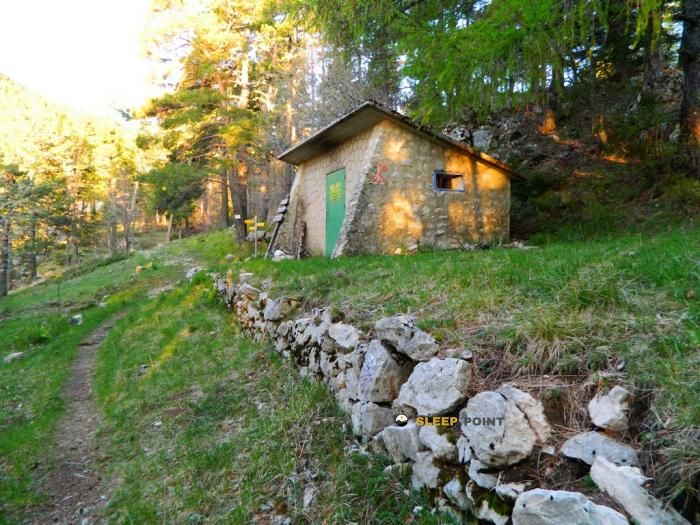
Mountain refuge La Bergerie des Salamandres
We have it listed in the app!
We have it listed in the app!


Located at 327 m above sea level, the La Bergerie des Salamandres refuge is a true haven of peace in la bergerie des salamandres, d 40, saint-léger-du-ventoux, carpentras, vaucluse, provenza-alpes-costa azul, francia metropolitana, 84390, francia. Connect with nature and use its coordinates (44.214, 5.255) to guide your steps to its door.
16.8°C
Feels like: 17.5°C1.8 km/h
Gusts: 6.8 km/h3950 m
Snow lineUV 1.2
Clouds: 100% 16.5 mm
 15.3 km/h
 UV máx: 5.8
 05:56
05:56
 21:17
0 mm
20.7 km/h
UV máx: 7.5
05:56
21:18
0 mm
8.3 km/h
UV máx: 7.7
05:56
21:19
0 mm
9.7 km/h
UV máx: 7.15
05:55
21:19
0 mm
17.2 km/h
UV máx: 7.4
05:55
21:20
0 mm
16.4 km/h
UV máx: 6.45
05:55
21:21
0 mm
20.6 km/h
UV máx: 7.45
05:55
21:21
21:17
0 mm
20.7 km/h
UV máx: 7.5
05:56
21:18
0 mm
8.3 km/h
UV máx: 7.7
05:56
21:19
0 mm
9.7 km/h
UV máx: 7.15
05:55
21:19
0 mm
17.2 km/h
UV máx: 7.4
05:55
21:20
0 mm
16.4 km/h
UV máx: 6.45
05:55
21:21
0 mm
20.6 km/h
UV máx: 7.45
05:55
21:21
La Bergerie des Salamandres It fits better as a point of retreat or reorganisation of the day than as a refuge to which all the logistics should be entrusted. In the surroundings of Saint-Léger-du-Ventoux, next to the D 40 and only 327 meters of altitude, its position brings it closer to the valley and to the accesses of the Ventoux than to a fully alpine location. It may therefore be useful to get down from higher levels, to divide a route along the Toulorenc side or to resolve a day that is complicated by meteorology, tiredness or change of plan.
Reading the ground around helps you understand your role. Up, the dominant reference is the Mont Ventoux , with reliefs that gain height quickly, while you close as the Bluye Sommet they mark a transition landscape between tracks, dry slopes and local trails. In this area there are half-distance itineraries such as Baumes des Eyguiers, Le Relais or the Circuit des Vignes, so that the passage of walkers exists, but not always with the continuity of a large signposted journey. That forces you to plan well links, escape and return to the valley.
As a mountain shelter within a route planning, it is appropriate to use it with a conservative criterion: it can be used as a support on a day on the north side of the Ventoux or as a reference when moving between small routes of the area, but nothing should be taken for granted that has not been proven before. The nearest source is about 1.7 km, a reasonable distance if the land is known, but sufficient not to have immediate water in the building itself. In a sector exposed to heat, wind and rapid changes in the environment between the valley and the hillside, basic autonomy remains the most prudent decision.


📏 3.9 Km
⛰️ 1370 m

📏 5.9 Km
⛰️ 1514 m

📏 7.5 Km
⛰️ 1142 m

📏 10.6 Km
⛰️ 1240 m

📏 12.3 Km
⛰️ 1165 m

📏 12.6 Km
⛰️ 656 m

📏 13.4 Km
⛰️ 1130 m

📏 17.9 Km
⛰️ 1145 m
Download the app and start looking for the shelter of your next adventure


Find a place to sleep before night falls.


