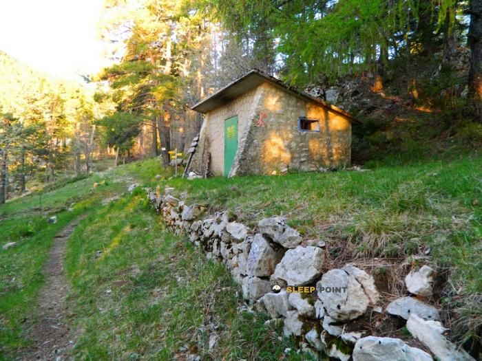
Mountain refuge Maison forestière Le Rat
We have it listed in the app!
We have it listed in the app!


Prepare your backpack and head to maison forestière le rat, d 164, sault, carpentras, vaucluse, provenza-alpes-costa azul, francia metropolitana, 84390, francia. There you will find the Maison forestière Le Rat refuge at 1240 meters of elevation. An essential stop along the way (Lat: 44.138, Lon: 5.335) for any mountain enthusiast.
11.8°C
Feels like: 7.2°C23.8 km/h
Gusts: 46.8 km/h4310 m
Snow lineUV 0
Clouds: 45% 17.1 mm
 33.8 km/h
 UV máx: 7
 05:56
05:56
 21:17
0 mm
26.6 km/h
UV máx: 6.25
05:56
21:17
0 mm
11.5 km/h
UV máx: 7.8
05:56
21:18
0 mm
11.2 km/h
UV máx: 7.5
05:55
21:19
0 mm
15.7 km/h
UV máx: 7.75
05:55
21:19
0 mm
24.5 km/h
UV máx: 6.75
05:55
21:20
0 mm
11.2 km/h
UV máx: 7.5
05:55
21:21
21:17
0 mm
26.6 km/h
UV máx: 6.25
05:56
21:17
0 mm
11.5 km/h
UV máx: 7.8
05:56
21:18
0 mm
11.2 km/h
UV máx: 7.5
05:55
21:19
0 mm
15.7 km/h
UV máx: 7.75
05:55
21:19
0 mm
24.5 km/h
UV máx: 6.75
05:55
21:20
0 mm
11.2 km/h
UV máx: 7.5
05:55
21:21
In the field of Sault , within the Provenza-Alpes-Costa Azul , Maison forestère Le Rat It fits better as a free-of-support shelter to organize a day with margin than as a simple improvised point of passage. Its position, at an average level of 1240 meters and in a forest environment linked to mountain tracks and roads, places it in a useful strip for those who travel along the area or need to divide the effort before continuing.
The most clear reference on the nearby mountain map is the area of Mont Ventoux , a mountain very exposed to the wind and to time changes that condition planning in its entire area of influence. In this context, this coat can make sense within several days or as a link to signposted traces. Close passes Le Chemin des Lavandes , and on a wider scale may also interest those who move by the logic of Tour des Baronnies provençales or for long journeys such as GR 91 , without direct connections or closed stages.
From a practical point of view, the approach should be considered with autonomy. There is a relatively close point of water, the Font d'Angiéu at about 1.3 km, useful data to adjust loading and reposting, but not to depend on it without checking real conditions on the ground. In an area where the wind can be a serious factor and where the orientation changes a lot between track, forest and open slopes, time management matters as much as distance.
For mountaineers and hiking trails, their usefulness is mainly to serve as logistical support on a long day, allowing to share effort and avoid stranded sections without breathing. If it is proposed as a free shelter, it is reasonable to have safe water, sufficient material and margin for adverse weather, especially if the route approaches higher levels of the Ventoux environment.


Download the app and start looking for the shelter of your next adventure


Find a place to sleep before night falls.