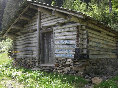
Mountain refuge Gîte de Molliessoulaz
We have it listed in the app!
We have it listed in the app!


The mountains of gîte de molliessoulaz, 5398, route de molliessoulaz, le cocu, queige, albertville, saboya, auvergne-rhône-alpes, francia metropolitana, 73720, francia hide essential places like the Gîte de Molliessoulaz refuge. Situated at an elevation of 980 meters, it offers protection and rest. Its exact coordinates are 45.708, 6.462.
12.8°C
Feels like: 12.4°C3.5 km/h
Gusts: 9.7 km/h3700 m
Snow lineUV 1.5
Clouds: 98% 31.6 mm
 18.8 km/h
 UV máx: 3.95
 05:46
05:46
 21:18
0 mm
7.4 km/h
UV máx: 3.9
05:46
21:19
0.4 mm
4.4 km/h
UV máx: 7.55
05:45
21:20
0 mm
6.9 km/h
UV máx: 6.8
05:45
21:20
0 mm
5.4 km/h
UV máx: 7.1
05:44
21:21
1.35 mm
9.2 km/h
UV máx: 1.9
05:44
21:22
0 mm
10.4 km/h
UV máx: 7.3
05:44
21:22
21:18
0 mm
7.4 km/h
UV máx: 3.9
05:46
21:19
0.4 mm
4.4 km/h
UV máx: 7.55
05:45
21:20
0 mm
6.9 km/h
UV máx: 6.8
05:45
21:20
0 mm
5.4 km/h
UV máx: 7.1
05:44
21:21
1.35 mm
9.2 km/h
UV máx: 1.9
05:44
21:22
0 mm
10.4 km/h
UV máx: 7.3
05:44
21:22
The approach to Gîte de Molliessoulaz part of a rather half-mountain terrain, on the heights of Queige, and from that 980-meter level the landscape quickly changes to much more marked forest slopes and reliefs of the Beaufortain. This transition is important to understand its function: it is not in the middle of a glacial environment or in an urban valley background, but in a strip of passage where the mountain is still accessible but is already oriented towards nearby peaks, shoulders and summits.
In this context, the shelter fits well as support for liaison days or to divide itineraries around the Tour du Beaufortain and its variant. It can also serve as a reference for exits to reliefs such as La Roche- Pourrie or the Mont Mirantin, where the land gains dislevel and alpine character as the forest is abandoned. It is not appropriate to interpret it as a simple road accommodation: its interest is in the transition between forest trails, open lomas and more demanding mountain.
The logistics here calls for a prudent reading. There is a very close source, practically near the point of the shelter, and there are several water points in the immediate environment, something useful in a passing area. However, in mountain areas it is always necessary to provide for basic autonomy and to confirm on the ground the actual flow or accessibility, especially if a long day or a link between stages is proposed.
Because of its location in Savoy, near Albertville and in the surroundings of Queige, it can fit in both local and wider tours. It is precisely for this reason that it interests more as a piece of strategy than as an isolated destination: a point from which to change the valley, link roads or gain height to a more open terrain, with meteorology and orientation gaining weight as the forest coverage is left behind.


📏 0.6 Km
⛰️ 1158 m

📏 1.7 Km
⛰️ 1470 m
📏 2.1 Km
⛰️ 1450 m

📏 2.2 Km
⛰️ 1620 m

📏 2.9 Km
⛰️ 1882 m

📏 3 Km
⛰️ 1170 m

📏 3 Km
⛰️ 1740 m

📏 3.3 Km
⛰️ 1570 m
Download the app and start looking for the shelter of your next adventure


Find a place to sleep before night falls.


