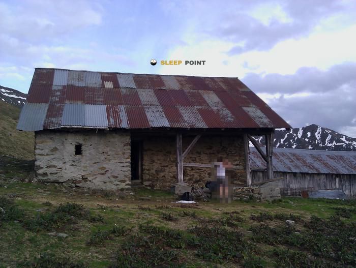
Mountain refuge Abri forestier des Steussets
We have it listed in the app!
We have it listed in the app!
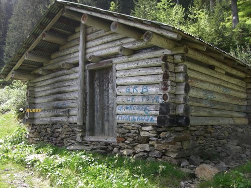

At 1450 meters above sea level, nestled in route du montet, molliessoulaz, queige, albertville, saboya, auvergne-rhône-alpes, francia metropolitana, 73720, francia, stands the Abri forestier des Steussets refuge. It is the perfect stop to spend the night or catch your breath. GPS coordinates: 45.703, 6.488.
9.4°C
Feels like: 6.9°C7.4 km/h
Gusts: 13.7 km/h3900 m
Snow lineUV 0
Clouds: 100% 28 mm
28 mm
 20.5 km/h
 UV máx: 5.2
 05:46
05:46
 21:18
1 mm
11.9 km/h
UV máx: 4.9
05:45
21:19
0 mm
10.5 km/h
UV máx: 7.55
05:45
21:20
0.5 mm
8.9 km/h
UV máx: 7.45
05:45
21:20
1.8 mm
9.8 km/h
UV máx: 7.1
05:44
21:21
9 mm
10.2 km/h
UV máx: 2
05:44
21:22
0 mm
6.8 km/h
UV máx: 7.35
05:44
21:22
21:18
1 mm
11.9 km/h
UV máx: 4.9
05:45
21:19
0 mm
10.5 km/h
UV máx: 7.55
05:45
21:20
0.5 mm
8.9 km/h
UV máx: 7.45
05:45
21:20
1.8 mm
9.8 km/h
UV máx: 7.1
05:44
21:21
9 mm
10.2 km/h
UV máx: 2
05:44
21:22
0 mm
6.8 km/h
UV máx: 7.35
05:44
21:22
On the Queige side, along the Molliessoulaz area and the route du Montet, the land changes quickly between forest mass, clear and slopes that already look to more open reliefs of the Beaufortain. In that context it appears Abri forester des Steussets , a free shelter at 1450 meters that fits more as a step support than as a destination in itself. The height is not extreme, but is sufficient to allow weather and visibility to change progression, especially when linking sections of forest to more exposed areas.
Its practical interest is to serve as an intermediate point within long or circular routes of the area. In the near future, variants of Tour du Beaufortain , in addition to local tours such as Forêt de Rhonne, L'Oratoire or the route to La Roche-Pourrie. This places it in a useful sector to divide days and reorganize a journey if time changes, without the need to immediately go down to the bottom of the valley. More than a base of pure ascension, it works as a shelter within a network of roads where orientation can become less evident by alternating track, path and half mountain terrain.
The near relief helps to understand that character. Upwards are references such as Mont Mirantin, Légette du Mirantin or La Roche-Pourrie, summits that mark a clearly mountainous environment even though the shelter is still in a transition strip between forest and high pastures. This position makes the place useful both in approaches and in long declines, especially when it is sought to share effort on routes with quite a change of direction.
An autonomous approach should be maintained for logistics. There is a source located approximately 1.1 km, a reasonable but not immediate distance, so the water must be provided before depending on it. Since no equipment or interior state data are provided here, it is wise to have your own margin and to review the conditions of the itinerary and time before using this free shelter in the Queige sector.


📏 1 Km
⛰️ 1170 m

📏 1.1 Km
⛰️ 1740 m

📏 1.1 Km
⛰️ 1882 m

📏 1.8 Km
⛰️ 1560 m

📏 2.1 Km
⛰️ 980 m

📏 2.2 Km
⛰️ 1158 m
📏 2.8 Km
⛰️ 1979 m

📏 2.8 Km
⛰️ 1470 m
Download the app and start looking for the shelter of your next adventure


Find a place to sleep before night falls.


