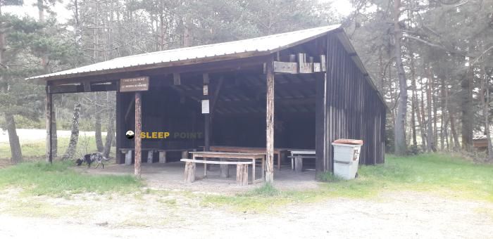
Mountain refuge Fournil de la Chaze
We have it listed in the app!
We have it listed in the app!


Discover the vastness of 38, route des fons, la chaze-de-peyre, peyre en aubrac, mende, lozère, occitania, francia metropolitana, 48130, francia by spending the night at the Fournil de la Chaze refuge. It sits at 1041 meters, offering a unique balcony over the natural landscape. Find it on the map at latitude 44.703 and longitude 3.253.
9°C
Feels like: 8.4°C1.5 km/h
Gusts: 4 km/h4000 m
Snow lineUV 0
Clouds: 100% 10.2 mm
 15.7 km/h
 UV máx: 1.2
 06:03
06:03
 21:27
0 mm
19 km/h
UV máx: 7.35
06:02
21:28
0 mm
19.2 km/h
UV máx: 7.35
06:02
21:29
0 mm
7.6 km/h
UV máx: 7.2
06:02
21:29
0.15 mm
14.9 km/h
UV máx: 7.6
06:01
21:30
0 mm
20.4 km/h
UV máx: 6.85
06:01
21:31
0 mm
13 km/h
UV máx: 7.45
06:01
21:31
21:27
0 mm
19 km/h
UV máx: 7.35
06:02
21:28
0 mm
19.2 km/h
UV máx: 7.35
06:02
21:29
0 mm
7.6 km/h
UV máx: 7.2
06:02
21:29
0.15 mm
14.9 km/h
UV máx: 7.6
06:01
21:30
0 mm
20.4 km/h
UV máx: 6.85
06:01
21:31
0 mm
13 km/h
UV máx: 7.45
06:01
21:31
In the surroundings of La Chaze-de-Peyre, within the municipality of Peyre in Aubrac, this small coat fits better as a step support than as a destination in itself. The area combines rural roads, the Aubrac's open relief and a network of itineraries that requires a good reading of the map, especially when used as a link between stages. At 1041 meters of altitude, the context is not that of a high-mountain pyrenian shelter, but that of a useful point for those who go through sectors exposed to the wind and with low-concentrated services.
Fournil de la Chaze is related to routes such as Tour des Monts d'Aubrac including some variant, and with the Aumont-Aubrac - Nasbinals . This closeness places it as a practical reference to divide a day, adjust a journey or contemplate a retreat to inhabited nuclei if the weather changes or the advance becomes complicated. It can also support shorter routes in the area, such as the route to the lac du Moulinet , although the specific distances depend on the chosen route.
Access is better understood from the logic of the territory than from an alpine approach: roads, tracks and trails that pass through small cores and open areas. That is why we should not be trusted. In this sector of the Aubrac, the orientation may become less intuitive when local variants or crosses are chained, and a shelter of this type also functions as an intermediate point of reference in navigation.
In the logistics part, there is a very close source, about 56 meters away, which can facilitate the revival of water during the march. Even so, in mountain and half mountain it is necessary to always confirm its real state before it depends on it. Since there is no solid data here on inside equipment, places or services, it is reasonable to raise the output with sufficient autonomy and use the place as basic support within prudent planning.
The most useful territorial reference is La Chaze-de-Peyre, in Lozère, an area of transit in which the small shelters and coats have value especially for their position. In that regard, Fournil de la Chaze fits well as a point of passage, stage reorganisation or escape to inhabited areas of the Peyre environment in Aubrac.


📏 1.7 Km
⛰️ 1085 m

📏 7.1 Km
⛰️ 1180 m

📏 8.8 Km
⛰️ 1100 m

📏 10 Km
⛰️ 1216 m

📏 11.3 Km
⛰️ 1213 m

📏 12.3 Km
⛰️ 1186 m

📏 13.8 Km
⛰️ 1060 m
📏 14.2 Km
⛰️ 965 m
Download the app and start looking for the shelter of your next adventure


Find a place to sleep before night falls.


