Mountain refuge Cabane Ste Catherine

We have it listed in the app!


            Mountain refuge Cabane Ste Catherine in cabane de ste catherine, chemin des michelons, les coins, eygliers, briançon, altos alpes, provenza-alpes-costa azul, francia metropolitana, 05600, francia
Five orange stars in a horizontal row representing a five-star rating.

Cabane Ste Catherine

Lat: 44.686xxx – Lon: 6.635xxx
📍 cabane de ste catherine, chemin des michelons, les coins, eygliers, briançon, altos alpes, provenza-alpes-costa azul, francia metropolitana, 05600, francia
Cabane Ste Catherine

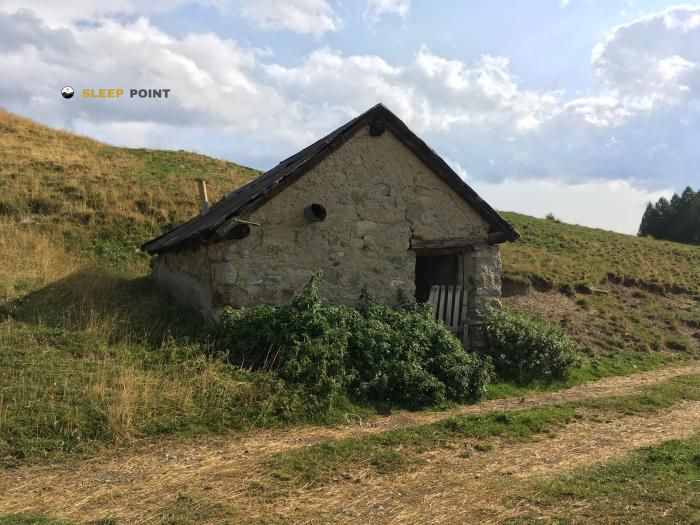
The Cabane Ste Catherine refuge (cabane de ste catherine, chemin des michelons, les coins, eygliers, briançon, altos alpes, provenza-alpes-costa azul, francia metropolitana, 05600, francia) is a classic meeting point for mountaineers and hikers. At 1080 meters, its coordinates 44.686, 6.635 mark the end of a stage or the beginning of a new adventure.

See more
See more
Usuario

Lucas Martinez

Premium user

Live weather: Cabane Ste Catherine

At the moment, conditions in Cabane Ste Catherine (1080m) show 11.7°C (feels like 9.8°C). Wind is blowing at 6.8 km/h with gusts up to 7.2 km/h. Today, a high of 20.7°C is expected and the freezing level is at 4170 meters.
Temperature

11.7°C

Feels like: 9.8°C
Wind

6.8 km/h

Gusts: 7.2 km/h
Freezing level 0°

4170 m

Snow line
Sky & UV

UV 0

Clouds: 100%

Next 48 hours evolution

7-day forecast

04/06
20.7° 10.8°
20.4 mm 18.1 km/h UV máx: 7.05
05:49 21:13
05/06
18.9° 8.2°
1.3 mm 13.9 km/h UV máx: 7.65
05:49 21:14
06/06
20.1° 11°
0 mm 15.8 km/h UV máx: 7.25
05:48 21:15
07/06
22° 10°
0 mm 14.2 km/h UV máx: 7.95
05:48 21:16
08/06
23.2° 12.7°
0 mm 16 km/h UV máx: 7.65
05:48 21:16
09/06
22.5° 13.5°
0 mm 12.9 km/h UV máx: 7.2
05:48 21:17
10/06
23.5° 10.1°
0 mm 13.7 km/h UV máx: 7.75
05:47 21:17

Support through the Guillestrois

Cabane Ste Catherine it fits well as an intermediate point to fractionate long days in the surroundings of Eygliers and the corridor of Guillestre. It does not stand out by extreme altitude, as it is around 1,080 meters, but by its useful position between walking paths and middle mountains that link with more far-reaching routes. In this sector they come together as the Tour du Queyras and variants of Via Alpina , so it can serve to order stages, shorten an approach or reserve forces before gaining higher ground.

The nearby landscape changes quickly. From a relatively low background, slopes and summits are raised that mark a more alpine relief than your point suggests. Up are references such as Prachaval or La Mays which help to understand the role of the shelter: not so much an immediate high summit base, but support in the transition between valley and mountain. That field reading matters. The effort can be concentrated on the approach or on the next day, according to the chosen itinerary.

For logistics, there should be no unconfirmed domestic resources and a margin of autonomy. If there is a source about 1.15 km, relevant data to plan water without taking for granted supply next to the shelter. In an area connected with long journeys such as GR 50 , this type of detail weighs more than comfort: access orientation, distribution of the gap and weather forecast can have a significant impact on the real utility of the Cabane Ste Catherine .

Hiking routes from the refuge

VA-R132

Via Alpina Red R132

↔ Variable distance
GRP TFS

Tour de la Font Sancte

↔ Variable distance
GR 58

Tour du Queyras

↔ 108 km
VA-R130

Via Alpina Red R130

↔ Variable distance
VA-R131

Via Alpina Red R131

↔ Variable distance
GR 50

Tour du Parc National des Écrins

↔ 369 km
Local

Via Domitia, Montgenèvre - Eygalières

↔ Variable distance
Local

Le Serre - Rif-Bel

↔ Variable distance

Nearby peaks

Les Ourgières

2257 m
Lat: 44.6888 Lon: 6.6687

Prachaval

2463 m
Lat: 44.7001 Lon: 6.6617

La Mayt

2617 m
Lat: 44.7087 Lon: 6.6613

La Platte

2259 m
Lat: 44.7293 Lon: 6.6391

Le Pic

2489 m
Lat: 44.7152 Lon: 6.6984

Rocher de l'Aigle

1510 m
Lat: 44.6644 Lon: 6.6826

Le Pain de Sucre

1160 m
Lat: 44.6655 Lon: 6.6613

Nearby water fountains

Fuente

1.15 Km
Lat: 44.6655 Lon: 6.6613

Fuente

1.97 Km
Lat: 44.6655 Lon: 6.6613

Fuente

2.09 Km
Lat: 44.6655 Lon: 6.6613

Fuente

2.12 Km
Lat: 44.6655 Lon: 6.6613

Potable water

2.15 Km
Lat: 44.6655 Lon: 6.6613

Fuente

2.6 Km
Lat: 44.6655 Lon: 6.6613

Fuente

2.85 Km
Lat: 44.6655 Lon: 6.6613

Fuente

3.05 Km
Lat: 44.6655 Lon: 6.6613
FAQ

Frequently asked questions

Pregunta frecuente
In which municipality or region is the Cabane Ste Catherine refuge located?
This refuge is located within the municipality of Eygliers, belonging to the community or region of Provenza-Alpes-Costa Azul.
Pregunta frecuente
Are there other mountain refuges near Cabane Ste Catherine?
Yes, nearby you can find other options to spend the night or take shelter. El refugio más próximo es el Cabane forestière du Bois-Durat, que se encuentra a aproximadamente 2.4 km de distancia.
Pregunta frecuente
At what exact altitude is the Cabane Ste Catherine refuge located?
The Cabane Ste Catherine refuge is located at an altitude of 1080 meters above sea level, in the natural surroundings of cabane de ste catherine, chemin des michelons, les coins, eygliers, briançon, altos alpes, provenza-alpes-costa azul, francia metropolitana, 05600, francia.
More areas

Other areas

Collaborative

Together we improve

image

Send your photos

You can upload photos of shelters and update their status so other users know if they can go there.

Get started
Get started
image

Rate the shelter

Leave your comments to rate the shelter’s condition. In the mountains, we look after each other.

Get started
Get started
image

Add new ones

Did we miss any? Publish the shelters you know so everyone can use them.

Get started
Get started
Download for free from the Apple App Store and Play Store.

Download the app and start looking for the shelter of your next adventure

Aplicación móvil para encontrar refugios de montaña donde dormir
Aplicación móvil para encontrar refugios de montaña donde dormir.
Mapa interactivo de refugios de montaña en los Pirineos dentro de la app
Mapa de refugios de montaña para senderismo y trekking en la app.
Pantalla con información de refugio de montaña con altitud capacidad y servicios
Pantalla con información de refugio de montaña con altitud capacidad y servicios.
Detalles de refugio de montaña con servicios y meteorología en aplicación móvil
Detalles de refugio de montaña con servicios y meteorología en aplicación móvil.
Aplicación para explorar refugios de montaña mediante mapa interactivo
Aplicación para explorar refugios de montaña mediante mapa interactivo.
Ficha completa de refugio de montaña con opiniones y servicios
Ficha completa de refugio de montaña con opiniones y servicios.
Información detallada de refugio en app para montañeros
Información detallada de refugio en app para montañeros.
Listado de refugios de montaña para senderismo y trekking
Listado de refugios de montaña para senderismo y trekking.
Explorar refugios de montaña desde una aplicación móvil
Explorar refugios de montaña desde una aplicación móvil.