Mountain refuge Cabane Sainte Marie
We have it listed in the app!
We have it listed in the app!
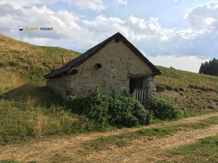

The Cabane Sainte Marie refuge stands at 1990 meters above sea level, overlooking the surroundings of chemin de la casse, cadoutre, saint-crépin, briançon, altos alpes, provenza-alpes-costa azul, francia metropolitana, 05600, francia. It is a key spot for mountaineers looking to spend the night or take a break. Its coordinates (44.72, 6.635) place it in a strategic position for exploring the peaks and trails of the region.
9.1°C
Feels like: 5.4°C11.1 km/h
Gusts: 15.5 km/h4160 m
Snow lineUV 0
Clouds: 100% 21.1 mm
 25 km/h
 UV máx: 7.7
 05:49
05:49
 21:13
1 mm
13.5 km/h
UV máx: 7.7
05:49
21:14
0 mm
15.1 km/h
UV máx: 8
05:48
21:15
0 mm
14.9 km/h
UV máx: 7.95
05:48
21:16
0 mm
22.2 km/h
UV máx: 7.6
05:48
21:16
0 mm
12.9 km/h
UV máx: 7
05:47
21:17
0 mm
13.7 km/h
UV máx: 7.7
05:47
21:17
21:13
1 mm
13.5 km/h
UV máx: 7.7
05:49
21:14
0 mm
15.1 km/h
UV máx: 8
05:48
21:15
0 mm
14.9 km/h
UV máx: 7.95
05:48
21:16
0 mm
22.2 km/h
UV máx: 7.6
05:48
21:16
0 mm
12.9 km/h
UV máx: 7
05:47
21:17
0 mm
13.7 km/h
UV máx: 7.7
05:47
21:17
Before you have this coat in support, you should take on a day with real autonomy. At about 1,990 meters, in the surroundings of Saint-Crépin and the Guillestrois, there is no immediate source next to the cabin according to the available data: the nearest one is just over 2 km, and the others are distributed at a greater distance. This forces the water to plan well and not to take for granted a comfortable supply when it comes, especially if it is linked with a long or unstable journey.
Cabane Sainte Marie it is in a very useful transition area between the reliefs that connect the sector of Guillestre, Saint-Crépin and the mountains that make way for the most routes. The surrounding terrain responds more to a mountain logic of orientation and link than to a simple walk in the background of the valley: cords, lomas and nearby steps both the approach and the continuity of the route. By this position, it can make sense as an intermediate point for those who move between long-range tracks such as the Via Alpina, the GR 58 Tour du Queyras or GR 50 Tour du Parc National des Écrins , always assessing if the deviation compensates against the main itinerary.
The next highlight reinforces that role as a support shelter. Summits like La Mays , Prachaval or the Pic du Béal Travertier sector draw a frame of medium and high mountain where the cabin can serve to break days, gain height for the next day or propose circular tours with alpine criteria. It does not appear here as a service base, but rather as a guard within a field where the meteorology, orientation and ability to move with margin weigh more.
If used within a journey, it is reasonable to arrive with enough water, food and a clear idea of the next link. The altitude and exposure of the sector can change the conditions between the bottom of the valley and the shelter. Mapping and alternatives should also be reviewed before being diverted, because in such locations the main value is not in comfort, but in its strategic function within a mountain route.


📏 1.5 Km
⛰️ 1585 m

📏 1.7 Km
⛰️ 1495 m

📏 3.8 Km
⛰️ 1080 m

📏 5.1 Km
⛰️ 1749 m

📏 6.1 Km
⛰️ 2291 m

📏 7.2 Km
⛰️ 2020 m

📏 7.5 Km
⛰️ 1950 m

📏 7.7 Km
⛰️ 1790 m
Download the app and start looking for the shelter of your next adventure


Find a place to sleep before night falls.


