Mountain refuge Cabane du col des Ubertes

We have it listed in the app!


            Mountain refuge Cabane du col des Ubertes in cabane du col des ubertes, d 151, le mazet, dourbies, le vigan, gard, occitania, francia metropolitana, 30750, francia
Five orange stars in a horizontal row representing a five-star rating.

Cabane du col des Ubertes

Lat: 44.087xxx – Lon: 3.466xxx
📍 cabane du col des ubertes, d 151, le mazet, dourbies, le vigan, gard, occitania, francia metropolitana, 30750, francia
Cabane du col des Ubertes

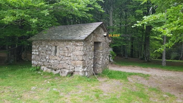
The Cabane du col des Ubertes refuge acts as a base camp for the summits and routes of cabane du col des ubertes, d 151, le mazet, dourbies, le vigan, gard, occitania, francia metropolitana, 30750, francia. At 1228 meters of elevation, its coordinates (44.087, 3.466) represent safety after a long day of effort.

See more
See more
Usuario

Lucas Martinez

Premium user

Live weather: Cabane du col des Ubertes

Live weather from Cabane du col des Ubertes shows 11.5°C and skies with 100% cloudiness. Wind is blowing at 7.4 km/h, lowering the feels-like temperature to 10.3°C. For high-altitude trips, the freezing level is at 3770 m and the maximum temperature will be 14.2°C.
Temperature

11.5°C

Feels like: 10.3°C
Wind

7.4 km/h

Gusts: 29.2 km/h
Freezing level 0°

3770 m

Snow line
Sky & UV

UV 0.75

Clouds: 100%

Next 48 hours evolution

7-day forecast

04/06
14.2° 8.1°
12.2 mm 28.7 km/h UV máx: 2.95
06:04 21:24
05/06
13.3° 4.9°
0 mm 32 km/h UV máx: 7.45
06:04 21:25
06/06
18.8° 7.2°
0 mm 19.2 km/h UV máx: 7.65
06:03 21:25
07/06
21.3° 9.8°
0 mm 9.5 km/h UV máx: 7.65
06:03 21:26
08/06
21.6° 13.5°
0 mm 16.1 km/h UV máx: 7.75
06:03 21:27
09/06
16.7° 10.4°
0 mm 21.4 km/h UV máx: 7.3
06:02 21:27
10/06
18.6° 8.2°
0 mm 14.8 km/h UV máx: 7.45
06:02 21:28

Between Dourbies and L'Espérou

Cabane du col des Ubertes is located in the Dourbies , in Occitania, at 1228 meters, on a passing point that fits more as road support than as a destination in itself. The environment responds to a medium mountain exposed to changes in orientation and time, where a collate can make clear differences between sides, wind and thermal sensation. This position makes it useful for those who walk through the area and needs to order the day with stage logic.

His practical interest appears especially when looking at the connections. In this sector, long-distance routes such as Tour du Mont Aigoual , GR 66 , GR 71 , GR 60 and variants such as 66A, in addition to sections identified between Meyrueis, L'Espérou and Le Vigan. It is not appropriate to read it as a basis for concrete ascendations, but as a point of protection within a wide-ranging network, useful for fractioning cross-roads or resolving a long stage in changing terrain.

The approach will depend a lot on the chosen itinerary, but the context suggests mountain progression without automatisms: hillside changes, steps by hill and sections where the general orientation of the journey influences the effort and exposure to the wind. At this altitude it is not on high mountain pirenaica, but it is on a land where meteorology can condition a long day.

It should also be put forward with logistical prudence. There are invented sources in the environment, although the nearest ones are just over 2 kilometres away, so it is not reasonable to have immediate water next to the shelter. To plan a night or step, it is wise to go out with sufficient autonomy and to check before the actual state of the water point that is intended to be used.

For the type of information available, this coat fits better into conservative planning: basic support on the road, useful when the stage is well known and less appropriate if it depends on finding secure services or resources on the ground.

Hiking routes from the refuge

CSG08

CSG 08 : Meyrueis - L'Espérou

↔ Variable distance
GR 60

Chemin du signal de Mailhebiau à Saint-Mathieu-de-Tréviers - Tracé principal

↔ 176.8 km
GR 66

Tour du Mont Aigoual

↔ Variable distance
66A

GR 66A

↔ Variable distance
CSG09

CSG 09 : L'Espérou - Le Vigan

↔ Variable distance
GR 71

De l'Espérou (Gard) au col de Fontfroide (Hérault)

↔ Variable distance
Local

CSG 09A : Déviation

↔ Variable distance
GR 7

Des Vosges aux Pyrénées 05, Prat Peyrot - Boussagues

↔ Variable distance

Nearby water fountains

Fuente

2.04 Km
Lat: 0 Lon: 0

Fuente

2.14 Km
Lat: 0 Lon: 0

Fuente

2.99 Km
Lat: 0 Lon: 0

Fuente

3.09 Km
Lat: 0 Lon: 0

Fuente

3.25 Km
Lat: 0 Lon: 0

Fuente

3.69 Km
Lat: 0 Lon: 0

Fuente

6.08 Km
Lat: 0 Lon: 0

Fuente

6.31 Km
Lat: 0 Lon: 0
FAQ

Frequently asked questions

Pregunta frecuente
In which municipality or region is the Cabane du col des Ubertes refuge located?
This refuge is located within the municipality of Dourbies, belonging to the community or region of Occitania.
Pregunta frecuente
Are there other mountain refuges near Cabane du col des Ubertes?
Yes, nearby you can find other options to spend the night or take shelter. El refugio más próximo es el Abri Pradier, que se encuentra a aproximadamente 1.3 km de distancia.
Pregunta frecuente
At what exact altitude is the Cabane du col des Ubertes refuge located?
The Cabane du col des Ubertes refuge is located at an altitude of 1228 meters above sea level, in the natural surroundings of cabane du col des ubertes, d 151, le mazet, dourbies, le vigan, gard, occitania, francia metropolitana, 30750, francia.
More areas

Other areas

Collaborative

Together we improve

image

Send your photos

You can upload photos of shelters and update their status so other users know if they can go there.

Get started
Get started
image

Rate the shelter

Leave your comments to rate the shelter’s condition. In the mountains, we look after each other.

Get started
Get started
image

Add new ones

Did we miss any? Publish the shelters you know so everyone can use them.

Get started
Get started
Download for free from the Apple App Store and Play Store.

Download the app and start looking for the shelter of your next adventure

Aplicación móvil para encontrar refugios de montaña donde dormir
Aplicación móvil para encontrar refugios de montaña donde dormir.
Mapa interactivo de refugios de montaña en los Pirineos dentro de la app
Mapa de refugios de montaña para senderismo y trekking en la app.
Pantalla con información de refugio de montaña con altitud capacidad y servicios
Pantalla con información de refugio de montaña con altitud capacidad y servicios.
Detalles de refugio de montaña con servicios y meteorología en aplicación móvil
Detalles de refugio de montaña con servicios y meteorología en aplicación móvil.
Aplicación para explorar refugios de montaña mediante mapa interactivo
Aplicación para explorar refugios de montaña mediante mapa interactivo.
Ficha completa de refugio de montaña con opiniones y servicios
Ficha completa de refugio de montaña con opiniones y servicios.
Información detallada de refugio en app para montañeros
Información detallada de refugio en app para montañeros.
Listado de refugios de montaña para senderismo y trekking
Listado de refugios de montaña para senderismo y trekking.
Explorar refugios de montaña desde una aplicación móvil
Explorar refugios de montaña desde una aplicación móvil.