Mountain refuge Cabane du Plan du Chataignier
We have it listed in the app!
We have it listed in the app!


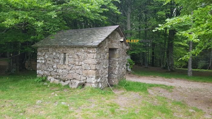
Located at 1195 m above sea level, the Cabane du Plan du Chataignier refuge is a true haven of peace in route de la serreyrède, valleraugue, saint-sauveur-camprieu, le vigan, gard, occitania, francia metropolitana, 30750, francia. Connect with nature and use its coordinates (44.105, 3.508) to guide your steps to its door.
10.1°C
Feels like: 8.2°C11 km/h
Gusts: 25.6 km/h4090 m
Snow lineUV 0
Clouds: 100% 14.9 mm
 24.8 km/h
 UV máx: 4.35
 06:04
06:04
 21:24
0 mm
29.7 km/h
UV máx: 6.9
06:03
21:25
0 mm
17.4 km/h
UV máx: 7.7
06:03
21:25
0 mm
7.3 km/h
UV máx: 6.85
06:03
21:26
0 mm
11.4 km/h
UV máx: 7.75
06:03
21:27
0.9 mm
21.4 km/h
UV máx: 7.05
06:02
21:27
0 mm
7.4 km/h
UV máx: 7.45
06:02
21:28
21:24
0 mm
29.7 km/h
UV máx: 6.9
06:03
21:25
0 mm
17.4 km/h
UV máx: 7.7
06:03
21:25
0 mm
7.3 km/h
UV máx: 6.85
06:03
21:26
0 mm
11.4 km/h
UV máx: 7.75
06:03
21:27
0.9 mm
21.4 km/h
UV máx: 7.05
06:02
21:27
0 mm
7.4 km/h
UV máx: 7.45
06:02
21:28
On the Occitania which links the reliefs of the Covennes with the heights close to the Mont Aigoual, the Cabane du Plan du Chataignier is at the end of Saint-Sauveur-Camprieu at 1,195 metres of altitude. This height places it in a half-mountain high strip where the landscape already changes quickly depending on the exposure, the wind and the season. More than a shelter associated with a large concentration of itineraries identified in the available data, it fits as a support coat within a transition ground between forest, open lomas and mountain access roads, in an area where it is appropriate to carry a good reading of the map and not to rely all the orientation to a single reference point.
Its practical interest is above all in the position: it can serve as a reference for those who move through this sector of the Gard looking for a simple basis from which to organize a day on foot or divide a wider tour of the massif. There are no specific summits or routes directly associated, so the most prudent thing is to understand it as a useful shelter for mountaineers with a certain autonomy, more oriented to plan on mapping than to follow an obvious succession of classical milestones. The municipal environment of Saint-Sauveur-Camprieu and the proximity of the Aigoual area help to place it in a context of humid, changing and often more exposed mountains than its altitude might suggest.
In terms of logistics, the most relevant data is the presence of a source at about 1.7 km, reasonable but not immediate distance. This advises not to have water next to the shelter and to review the supply well before the exit, especially if a long day or with unstable weather occurs. As there is no reliable information here on internal equipment, capacity or current state, planning must be done with margin and self-sufficiency. In this type of shelter, the orientation, water and weather forecast weigh more than the idea of finding services resolved upon arrival.


📏 2.5 Km
⛰️ 1455 m

📏 2.7 Km
⛰️ 1172 m

📏 3.8 Km
⛰️ 1006 m

📏 3.9 Km
⛰️ 1000 m
📏 3.9 Km
⛰️ 1228 m

📏 4 Km
⛰️ 1321 m

📏 5 Km
⛰️ 1185 m

📏 6.1 Km
⛰️ 1555 m
Download the app and start looking for the shelter of your next adventure


Find a place to sleep before night falls.


