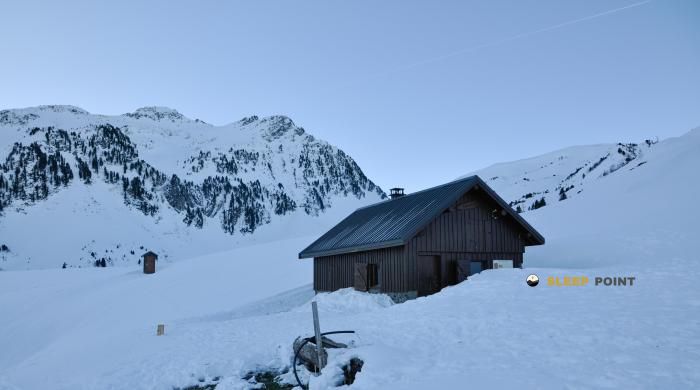
Mountain refuge Cabane de Praz noir
We have it listed in the app!
We have it listed in the app!


With a privileged location in passage de vachevieille, saint-léger, saint-jean-de-maurienne, saboya, auvergne-rhône-alpes, francia metropolitana, 73220, francia, the Cabane de Praz noir refuge awaits you at 1945 meters of altitude. Note its position (45.434, 6.233) before starting your route through the mountain range or massif.
5.7°C
Feels like: 2.5°C5.8 km/h
Gusts: 7.9 km/h4060 m
Snow lineUV 0
Clouds: 99% 34.3 mm
 21.3 km/h
 UV máx: 4.6
 05:48
05:48
 21:18
1.4 mm
8.9 km/h
UV máx: 6.5
05:48
21:19
0 mm
11.4 km/h
UV máx: 7.6
05:47
21:20
0.5 mm
10.3 km/h
UV máx: 7.3
05:47
21:20
1.65 mm
8.6 km/h
UV máx: 6.8
05:47
21:21
4.5 mm
10.9 km/h
UV máx: 3.25
05:46
21:22
0 mm
8.9 km/h
UV máx: 7.4
05:46
21:22
21:18
1.4 mm
8.9 km/h
UV máx: 6.5
05:48
21:19
0 mm
11.4 km/h
UV máx: 7.6
05:47
21:20
0.5 mm
10.3 km/h
UV máx: 7.3
05:47
21:20
1.65 mm
8.6 km/h
UV máx: 6.8
05:47
21:21
4.5 mm
10.9 km/h
UV máx: 3.25
05:46
21:22
0 mm
8.9 km/h
UV máx: 7.4
05:46
21:22
At 1,945 metres, the Cabane de Praz noir It appears on a land already clearly mountainous, on the Saboyan side of Belledonne and above the valley bottom of the Saint- Léger area. Its position fits either as a step coat or as an intermediate point to distribute a day in a sector of cords and hills where the relief gains prominence and the orientation of the itinerary matters more than the proximity to inhabited cores.
From this environment you understand your interest in linking routes of crossing and exits of medium and high mountain. The proximity of the Pointe de Rognier and Le Chapotet It strengthens this character of refuge linked to high lomas and nearby summits, more useful to move between steps and divisives than as a simple isolated destination. In addition, in the area the Haute Traversée de Belledonne by the GR 738, so it can make sense within a stage planning in this massif. It also connects with local itineraries such as the passage through the col d'Arpingon, which help to relate it to the access of the valley and with circular routes of greater or lesser demand.
In logistics it is necessary to have reasonable autonomy. There is a source located just over 1 km away, an assumed but not immediate distance, so it is not appropriate to take the water for granted by the shelter. The altitude and exposure of this type of location suggest rapid time changes, especially if it is continued to hills or peaks. For those who use it as road support, its value is above all in that position of link between valley, corral and cross.


📏 1 Km
⛰️ 1450 m

📏 1.1 Km
⛰️ 1673 m

📏 1.1 Km
⛰️ 1450 m
📏 1.1 Km
⛰️ 1812 m

📏 1.5 Km
⛰️ 1695 m

📏 2 Km
⛰️ 1778 m

📏 2.4 Km
⛰️ 1853 m
📏 2.8 Km
⛰️ 1567 m
Download the app and start looking for the shelter of your next adventure


Find a place to sleep before night falls.


