Mountain refuge Baraque de la Jasse
We have it listed in the app!
We have it listed in the app!
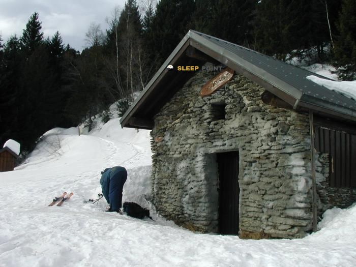

The Baraque de la Jasse refuge stands at 1567 meters above sea level, overlooking the surroundings of baraque de la jasse, route forestière de la jasse, saint-alban-d'hurtières, saint-jean-de-maurienne, saboya, auvergne-rhône-alpes, francia metropolitana, 73220, francia. It is a key spot for mountaineers looking to spend the night or take a break. Its coordinates (45.458, 6.225) place it in a strategic position for exploring the peaks and trails of the region.
9.2°C
Feels like: 6°C8.2 km/h
Gusts: 25.2 km/h3930 m
Snow lineUV 0
Clouds: 100% 34 mm
34 mm
 18.8 km/h
 UV máx: 4.95
 05:48
05:48
 21:18
0.8 mm
9.5 km/h
UV máx: 6.25
05:48
21:19
0 mm
9.3 km/h
UV máx: 7.7
05:47
21:20
0 mm
9.2 km/h
UV máx: 7.65
05:47
21:20
1.2 mm
8.3 km/h
UV máx: 7.2
05:46
21:21
4.5 mm
10.9 km/h
UV máx: 1.25
05:46
21:22
0 mm
8.9 km/h
UV máx: 7.45
05:46
21:22
21:18
0.8 mm
9.5 km/h
UV máx: 6.25
05:48
21:19
0 mm
9.3 km/h
UV máx: 7.7
05:47
21:20
0 mm
9.2 km/h
UV máx: 7.65
05:47
21:20
1.2 mm
8.3 km/h
UV máx: 7.2
05:46
21:21
4.5 mm
10.9 km/h
UV máx: 1.25
05:46
21:22
0 mm
8.9 km/h
UV máx: 7.45
05:46
21:22
The day should be raised with basic margin and autonomy. Although in the Barque de la Jasse There is a very close source, the actual availability of mountain water may vary, and the site, in the route forestière of the Jasse on Saint-Alban-d'Hurtières, works more as a step point and reorganisation of stage than as a place to improvise. At 1,567 meters, the environment already requires a good reading of the meteorology and a management of the effort from the approach, especially if long sections are linked.
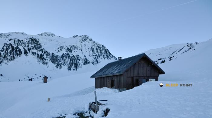
This shelter is inserted into the Saboyan side of Belledonne, in a strip where the land changes quickly. Access and continuations can start between forest mass, gain more open slopes and, according to the chosen itinerary, move towards more mineral hills and reliefs. This transition between open forest and mountain influences progression: it is not the same to advance protected by trees as to do so in areas exposed to the wind or with changing visibility. The orientation can also become more delicate when leaving the track or the most obvious path to search for steps between loins and basin changes.
Its role is particularly clear in the planning of cross-ships. The closeness of the Haute Traversée de Belledonne and GR 738 It makes it a useful reference to divide days, link sides or adjust a stage before facing higher sectors. In this sense, the barque does not stand out for both isolated access and its position within a network of itineraries that connect forests, ports and secondary crest of the massif. It can also support local tours through Arpingon, the Frêche or the Noire Combe, always with variable distances and development according to the chosen combination.
In the immediate environment there are highlights such as Grand Chat or the Rognier Pointe, which help to understand the mountainous character of the area without necessarily turning this point into a direct ascension base. The most important thing here is its cartographic and logistical value: a coat on an intermediate level, well placed to order the transition between valley, forest and more alpine terrain, and to better fit a stage in Belledonne without depending on long descends to the bottom of the valley.


📏 1.3 Km
⛰️ 1695 m

📏 1.6 Km
⛰️ 1425 m

📏 1.7 Km
⛰️ 1470 m

📏 2 Km
⛰️ 1450 m

📏 2.1 Km
⛰️ 1226 m
📏 2.4 Km
⛰️ 1812 m

📏 2.5 Km
⛰️ 1673 m

📏 2.6 Km
⛰️ 990 m
Download the app and start looking for the shelter of your next adventure


Find a place to sleep before night falls.


