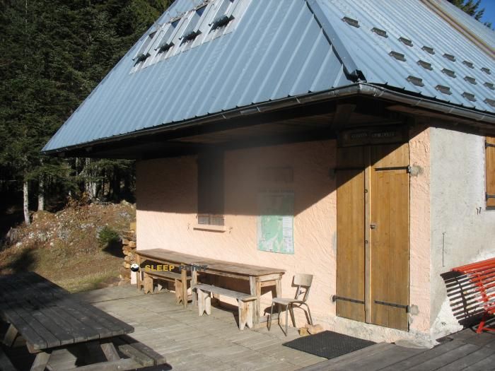
Mountain refuge Cabane de Larcoutier
We have it listed in the app!
We have it listed in the app!


If you are looking for total disconnection, venture into piste classique retiède, les déserts, chambéry, saboya, auvergne-rhône-alpes, francia metropolitana, 73230, francia until you reach the Cabane de Larcoutier refuge, positioned at 1371 meters. Use your device to navigate to the exact point (45.666, 5.984) to find this alpine shelter.
9°C
Feels like: 6.6°C4.3 km/h
Gusts: 7.6 km/h4030 m
Snow lineUV 0
Clouds: 93% 33.9 mm
 14.5 km/h
 UV máx: 4.05
 05:48
05:48
 21:20
12.7 mm
13.8 km/h
UV máx: 5.8
05:48
21:21
0 mm
12.1 km/h
UV máx: 7.45
05:47
21:21
0 mm
8.1 km/h
UV máx: 7.25
05:47
21:22
3.3 mm
7.9 km/h
UV máx: 7.05
05:46
21:23
10.8 mm
9.4 km/h
UV máx: 6.3
05:46
21:23
0 mm
8.2 km/h
UV máx: 7.25
05:46
21:24
21:20
12.7 mm
13.8 km/h
UV máx: 5.8
05:48
21:21
0 mm
12.1 km/h
UV máx: 7.45
05:47
21:21
0 mm
8.1 km/h
UV máx: 7.25
05:47
21:22
3.3 mm
7.9 km/h
UV máx: 7.05
05:46
21:23
10.8 mm
9.4 km/h
UV máx: 6.3
05:46
21:23
0 mm
8.2 km/h
UV máx: 7.25
05:46
21:24
The approach runs through half mountain terrain of the massif of Les Bauges in the environment of Les Déserts , with slopes and slopes that work more as a transition space than as a high hard mountain. The Cabane de Larcoutier , at 1371 meters, it fits well in exits of well-known trails to be oriented with a map and to move through wide reliefs, where the shelter serves above all as an intermediate reference and on-time coat within a day of open heights.
Its position helps to read the ground between the nearby heights of the sector. Very close appears Mont Revard and something further up Mont Margeriaz , L'Orionde or the towers and crosses that mark the relief of this part of Savoy. It is not so much a refuge linked to a great concrete ascension as a useful point for those who travel divisives, links looms or need a clear reference between aspects of the massif. In this context, the cabin has an interest for mountaineers who value the simple navigation on mapping, the continuity of the terrain and the possibility of reorganizing the day without dependent on immediate inhabited cores.
The atmosphere here is closer to the prealpine mountain than to the glacier or very mineral terrain. However, the altitude and exposure to the changing time of the crest of Les Bauges force not to banalize the exit. Fog, wind or reduced visibility can complicate the orientation even in seemingly friendly reliefs, especially if it is intended to link secondary hills and tops around the shelter.
Basic autonomy is needed in planning. The nearest source is just over 2 kilometres away, so it is not wise to take the water for granted in the immediate surroundings of the cabin. As there are no specific associated routes, it is most reasonable to understand the Cabane de Larcoutier as mountain support and local reference point within the Les Déserts , not as a basis for a specific signposted route.


📏 5.6 Km
⛰️ 1350 m

📏 5.9 Km
⛰️ 1510 m
📏 5.9 Km
⛰️ 1300 m

📏 6.1 Km
⛰️ 1350 m

📏 6.6 Km
⛰️ 995 m

📏 6.8 Km
⛰️ 1295 m

📏 6.8 Km
⛰️ 1325 m

📏 7.3 Km
⛰️ 1335 m
Download the app and start looking for the shelter of your next adventure


Find a place to sleep before night falls.


