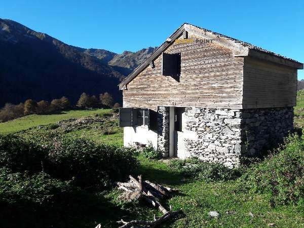
Mountain refuge Cabane d'Isarce
We have it listed in the app!
We have it listed in the app!


The mountains of cabane de l'isarce, sentier des liots, asson, pau, pyrénées-atlantiques, nueva aquitania, francia metropolitana, 64800, francia hide essential places like the Cabane d'Isarce refuge. Situated at an elevation of 1285 meters, it offers protection and rest. Its exact coordinates are 43.077, -0.197.
9.9°C
Feels like: 10°C1.3 km/h
Gusts: 5.4 km/h3880 m
Snow lineUV 0
Clouds: 100% 17.95 mm
 18 km/h
 UV máx: 1.65
 06:22
06:22
 21:35
0.2 mm
9.4 km/h
UV máx: 7.45
06:22
21:36
0.8 mm
8.1 km/h
UV máx: 5.7
06:22
21:36
0.5 mm
7.4 km/h
UV máx: 7.55
06:21
21:37
3.3 mm
10.6 km/h
UV máx: 3.05
06:21
21:38
3.6 mm
7.3 km/h
UV máx: 5.85
06:21
21:38
0 mm
9.1 km/h
UV máx: 7.45
06:21
21:39
21:35
0.2 mm
9.4 km/h
UV máx: 7.45
06:22
21:36
0.8 mm
8.1 km/h
UV máx: 5.7
06:22
21:36
0.5 mm
7.4 km/h
UV máx: 7.55
06:21
21:37
3.3 mm
10.6 km/h
UV máx: 3.05
06:21
21:38
3.6 mm
7.3 km/h
UV máx: 5.85
06:21
21:38
0 mm
9.1 km/h
UV máx: 7.45
06:21
21:39
On this side of Asson , Cabane d'Isarce It appears more as a point of continuity on the mountain than as a valley shelter. The environment combines forest, clear of grass and soft but open crests, in a pirenaic strip where the relief begins to gain amplitude and the orientation of the terrain matters. Its position fits well with itineraries that travel the spades and cords of the area, and also with the passage of the GR 101 , the Chemin de l'Ouest de Bigorre, which gives context of passage to this coat.
At 1285 meters, your interest is in supporting you to move along the local trails of L'Isarce et les Crêtes , link to routes like Les Estives de l'Aoulhet or divide a day in this sector between the Atlantic Pyrenees and the field of Bigorre. Small but useful reliefs are raised near to read the ground, such as Les Toupiettes or Marti Peyras , which help to understand the character of the middle and high mountain of the area: nearby summits, exposed lomas and rapid changes of environment between forest and crest. More than a base for great ascendations, it works as a free shelter for links, long-time exits or simple trekking through pastorile and mountain terrain.
Logistics requires some autonomy. There are no immediate water points next to the shelter and the registered sources are several kilometres away, so it is necessary to get out with sufficient water and not to take for granted the supply in the vicinity. It is also reasonable to foresee changes in time, fog or wind in the most open parts of the journey, especially if crests or hills are linked. In a sector with quite a network of trails, this type of coat is most useful when it comes up with previous planning of itinerary, water and time range.


📏 0 Km
⛰️ 1285 m

📏 1 Km
⛰️ 1350 m

📏 2.1 Km
⛰️ 1393 m

📏 2.9 Km
⛰️ 1159 m
📏 3.2 Km
⛰️ 1300 m

📏 5.1 Km
⛰️ 1400 m

📏 5.7 Km
⛰️ 1440 m

📏 6 Km
⛰️ 1220 m
Download the app and start looking for the shelter of your next adventure


Find a place to sleep before night falls.


