Mountain refuge Cabane
We have it listed in the app!
We have it listed in the app!
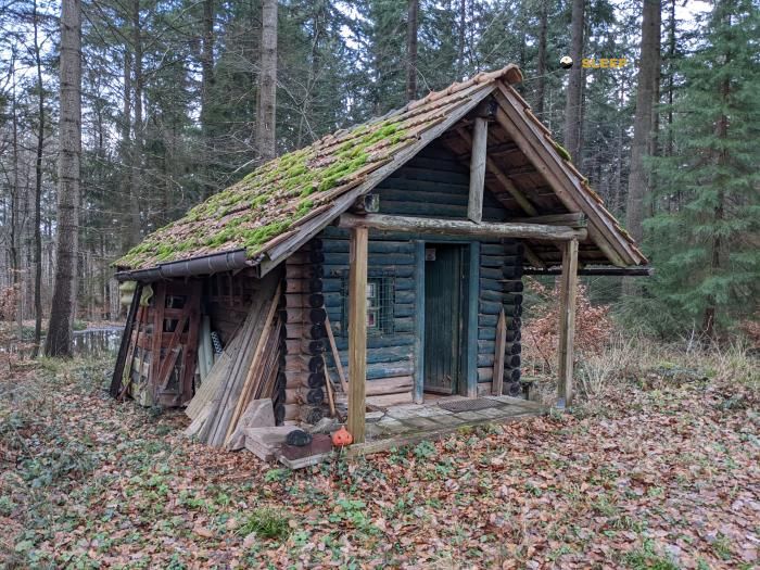

Discover the vastness of neuerweg, altdorf, ettenheim, vvg der stadt ettenheim, ortenaukreis, baden-wurtemberg, 77955, alemania by spending the night at the Cabane refuge. It sits at 520 meters, offering a unique balcony over the natural landscape. Find it on the map at latitude 48.269 and longitude 7.897.
15°C
Feels like: 11.9°C17.7 km/h
Gusts: 39.6 km/h3220 m
Snow lineUV 0
Clouds: 92% 5.3 mm
 22.2 km/h
 UV máx: 5.8
 05:30
05:30
 21:23
3 mm
14.5 km/h
UV máx: 6.7
05:29
21:24
0.5 mm
14.2 km/h
UV máx: 6.65
05:29
21:25
0 mm
11.3 km/h
UV máx: 6.3
05:28
21:25
1.95 mm
10.3 km/h
UV máx: 6.85
05:28
21:26
15.9 mm
14.4 km/h
UV máx: 5.6
05:28
21:27
0 mm
7.7 km/h
UV máx: 6.75
05:27
21:27
21:23
3 mm
14.5 km/h
UV máx: 6.7
05:29
21:24
0.5 mm
14.2 km/h
UV máx: 6.65
05:29
21:25
0 mm
11.3 km/h
UV máx: 6.3
05:28
21:25
1.95 mm
10.3 km/h
UV máx: 6.85
05:28
21:26
15.9 mm
14.4 km/h
UV máx: 5.6
05:28
21:27
0 mm
7.7 km/h
UV máx: 6.75
05:27
21:27
In the field of Ettenheim , inside Baden-Wurtemberg, this small cabane appears on a modest 520-meter level, more linked to the wavy relief of transition than to the high mountain. Even so, its position may be useful when reading the map on the ground: it is left in a strip of forest hills and short elevations where visual references are not always as open as in a clear string. Close summits like Großer Grassert, just over 2 km away, or Gierifuß help to place the environment and understand that it is a half-mountain area, with continuous changes in direction and contained but cumulative levels in progress.
More than as an isolated destination, Cabane fits as an intermediate reference to order a walking day between signposted itineraries of the area. In this environment, routes such as Breisgauer Weinweg or Achatweg , so it can be used to divide sections, readjust one stage or confirm the orientation before following to other local loops and links. In a network of roads with several options, having a recognizable point in the middle of the journey helps to better manage the effort and not to extend the day by unnecessary deviations.
The exit should be considered with some autonomy. The registered sources are not attached to the shelter, but from about 2.7 kilometres away, so it is not wise to take the water for granted in the vicinity. It is also important to review the planned route, because in this type of land the navigation depends less on a large alpine reference and more on crosses, tracks and small linked tops. This combination makes the shelter worth above all in support of orientation and as a practical milestone within a stage of the forest hills around Ettenheim.


📏 1.3 Km
⛰️ 480 m

📏 2.2 Km
⛰️ 330 m

📏 21.1 Km
⛰️ 789 m

📏 22.4 Km
⛰️ 640 m

📏 28.3 Km
⛰️ 835 m
📏 36.8 Km
⛰️ 286 m

📏 36.9 Km
⛰️ 308 m

📏 37.4 Km
⛰️ 300 m
Download the app and start looking for the shelter of your next adventure


Find a place to sleep before night falls.


