Mountain refuge Cabaña de Posets

We have it listed in the app!


            Mountain refuge Cabaña de Posets in cabaña de posets, canal fonda (nevero superior), sahún, ribagorza, huesca, aragón, 22469, españa
Five orange stars in a horizontal row representing a five-star rating.

Cabaña de Posets

Lat: 42.675xxx – Lon: 0.471xxx
📍 cabaña de posets, canal fonda (nevero superior), sahún, ribagorza, huesca, aragón, 22469, españa
Cabaña de Posets

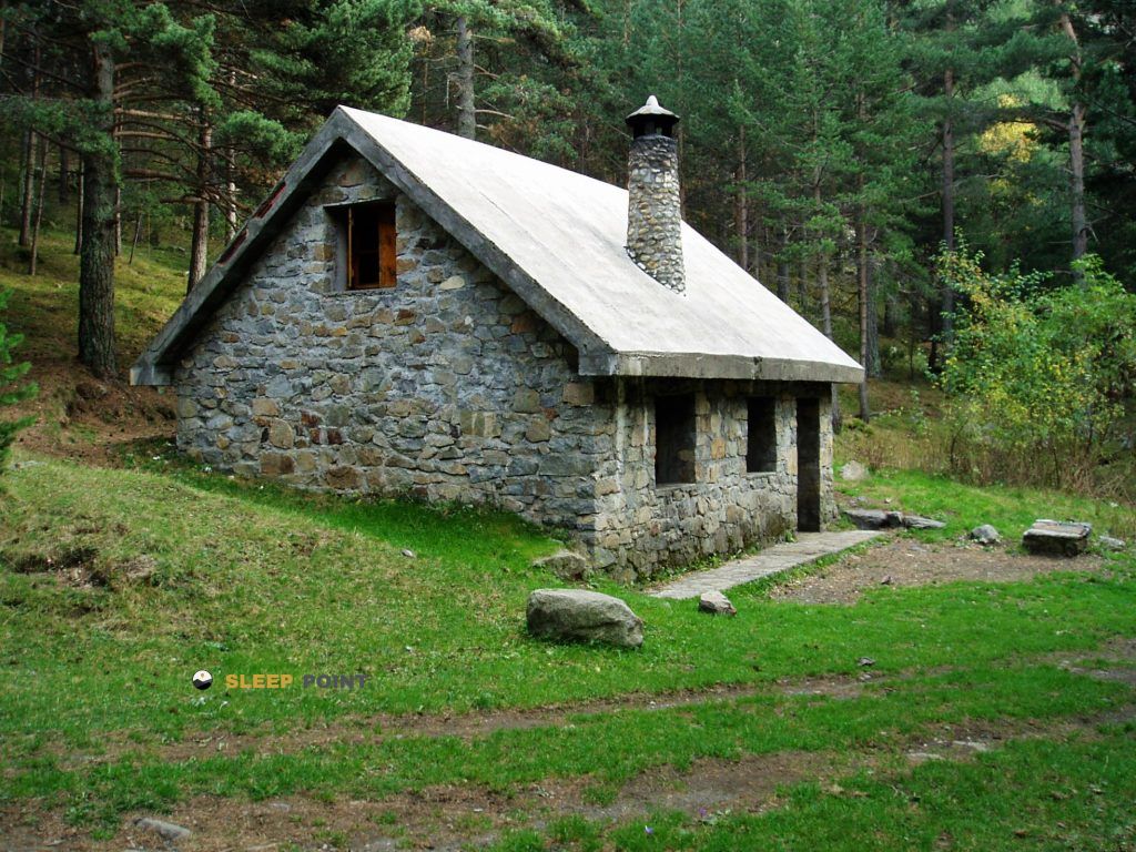
If you are planning a route through cabaña de posets, canal fonda (nevero superior), sahún, ribagorza, huesca, aragón, 22469, españa, the Cabaña de Posets refuge is a must-stop. Located at 1994 m above sea level, it offers hikers and climbers a safe place to regain strength. Save its coordinates (42.675, 0.471) in your GPS to stay on course during your journey.

See more
See more
Usuario

Lucas Martinez

Premium user

Live weather: Cabaña de Posets

Attention hikers heading to Cabaña de Posets: current conditions are 9.2°C (feels like 7.9°C due to 5 km/h wind). Beware of gusts up to 6.8 km/h. Snow level at 4490 m, UV index at 0, and an expected high of 12°C.
Temperature

9.2°C

Feels like: 7.9°C
Wind

5 km/h

Gusts: 6.8 km/h
Freezing level 0°

4490 m

Snow line
Sky & UV

UV 0

Clouds: 100%

Next 48 hours evolution

7-day forecast

04/06
12° 3.7°
13 mm 14.4 km/h UV máx: 6.25
06:21 21:31
05/06
11.2° 2.8°
0 mm 14.6 km/h UV máx: 8.15
06:21 21:32
06/06
14.7° 4.3°
0 mm 5.4 km/h UV máx: 7.65
06:20 21:32
07/06
16.5° 5.5°
0 mm 7.5 km/h UV máx: 7.95
06:20 21:33
08/06
17° 6.1°
3.3 mm 8.7 km/h UV máx: 8.15
06:20 21:34
09/06
10.7° 3.5°
0.6 mm 8 km/h UV máx: 4.7
06:20 21:34
10/06
17.8° 6.4°
0.6 mm 6.8 km/h UV máx: 7.9
06:19 21:35

The reference of Canal Fonda and the upper nay already places the ground: a high mountain slope where the orientation changes quickly between more attached sections and open areas, and where the progression can feel very different according to residual snow, wind or visibility. In this sector of the Posets massif, within the Oscense Ribagorza, the relief gains prominence over any comfort. The closeness of tops like the Tuca de Posets and the Tuca de Gorgs Bllancs strengthens this alpine character, with itineraries that usually require reading of the ground and careful management of the effort, especially when linking channels, loops and high steps. The altitude of the Posets' cabin around 1,994 meters helps to understand both the environment and exposure to time changes.

In practice, this cabin functions as basic support for those who move around the area or seek to break down long days in a very mountainous environment. Its position fits with the ascent to the Posets and also with the passage of the HRP in near stages, so it can serve as an intermediate reference rather than as a destination in itself. It is not necessary to have immediate near water: the registered sources are several kilometres away, so water autonomy and conservative planning are important from the exit. It is also reasonable to provide for variable conditions and not to base the day on assumptions about equipment or services. In a sector like this, the utility of the free shelter is mainly to offer shelter within a demanding route, where orientation, meteorology and continuity of progress weigh more than the distance on the map.

Hiking routes from the refuge

GR 19

Senderos del Sobrarbe

↔ 80 km
HRP

Étape 18

↔ Variable distance
HRP

Étape 19

↔ Variable distance
HRP

HRP Étape 20

↔ Variable distance
HRP

Étape 21

↔ Variable distance
Local

Ascensión al Posets

↔ Variable distance
Local

Vias Ferratas de Huesca

↔ Variable distance
Local

Le cirque des Crabioules

↔ Variable distance

Nearby peaks

Tuca de Posets

3368.60 m
Lat: 42.6546 Lon: 0.4352

Pico Chistau

2794 m
Lat: 42.6836 Lon: 0.4399

Pic des Spijeoles

3065 m
Lat: 42.7101 Lon: 0.4848

Tuca de Gorgs Bllancs

3129 m
Lat: 42.7 Lon: 0.4777

Aygues Tortes / Royo

2873 m
Lat: 42.6912 Lon: 0.4263

Tusse de Montarqué

2883 m
Lat: 42.7043 Lon: 0.499

Tuca Roya de Lliterola

3122 m
Lat: 42.6976 Lon: 0.5209

Pic Gourdon

3034 m
Lat: 42.7053 Lon: 0.483

Nearby water fountains

Fuente

4.41 Km
Lat: 42.7053 Lon: 0.483

Fuente

5.42 Km
Lat: 42.7053 Lon: 0.483

Fuente

6.59 Km
Lat: 42.7053 Lon: 0.483

Fuente

7.81 Km
Lat: 42.7053 Lon: 0.483

Fuente

8.44 Km
Lat: 42.7053 Lon: 0.483

Fuente

8.68 Km
Lat: 42.7053 Lon: 0.483

Fuente

8.71 Km
Lat: 42.7053 Lon: 0.483

Fuente

8.73 Km
Lat: 42.7053 Lon: 0.483
FAQ

Frequently asked questions

Pregunta frecuente
In which municipality or region is the Cabaña de Posets refuge located?
This refuge is located within the municipality of Ribagorza, belonging to the community or region of Aragón.
Pregunta frecuente
Are there other mountain refuges near Cabaña de Posets?
Yes, nearby you can find other options to spend the night or take shelter. El refugio más próximo es el Refuge d'Estos, que se encuentra a aproximadamente 1.2 km de distancia.
Pregunta frecuente
At what exact altitude is the Cabaña de Posets refuge located?
The Cabaña de Posets refuge is located at an altitude of 1994 meters above sea level, in the natural surroundings of cabaña de posets, canal fonda (nevero superior), sahún, ribagorza, huesca, aragón, 22469, españa.
More areas

Other areas

Collaborative

Together we improve

image

Send your photos

You can upload photos of shelters and update their status so other users know if they can go there.

Get started
Get started
image

Rate the shelter

Leave your comments to rate the shelter’s condition. In the mountains, we look after each other.

Get started
Get started
image

Add new ones

Did we miss any? Publish the shelters you know so everyone can use them.

Get started
Get started
Download for free from the Apple App Store and Play Store.

Download the app and start looking for the shelter of your next adventure

Aplicación móvil para encontrar refugios de montaña donde dormir
Aplicación móvil para encontrar refugios de montaña donde dormir.
Mapa interactivo de refugios de montaña en los Pirineos dentro de la app
Mapa de refugios de montaña para senderismo y trekking en la app.
Pantalla con información de refugio de montaña con altitud capacidad y servicios
Pantalla con información de refugio de montaña con altitud capacidad y servicios.
Detalles de refugio de montaña con servicios y meteorología en aplicación móvil
Detalles de refugio de montaña con servicios y meteorología en aplicación móvil.
Aplicación para explorar refugios de montaña mediante mapa interactivo
Aplicación para explorar refugios de montaña mediante mapa interactivo.
Ficha completa de refugio de montaña con opiniones y servicios
Ficha completa de refugio de montaña con opiniones y servicios.
Información detallada de refugio en app para montañeros
Información detallada de refugio en app para montañeros.
Listado de refugios de montaña para senderismo y trekking
Listado de refugios de montaña para senderismo y trekking.
Explorar refugios de montaña desde una aplicación móvil
Explorar refugios de montaña desde una aplicación móvil.