Mountain refuge Cabane de Prat-Cazeneuve Ou Aygues Tortes

We have it listed in the app!


            Mountain refuge Cabane de Prat-Cazeneuve Ou Aygues Tortes in refuge de prat-cazeneuve ou d'aygues tortes, sentier du lac de clarabide à pouchergues, loudenvielle, bagnères-de-bigorre, altos pirineos, occitania, francia metropolitana, 65510, francia
Five orange stars in a horizontal row representing a five-star rating.

Cabane de Prat-Cazeneuve Ou Aygues Tortes

Lat: 42.704xxx – Lon: 0.438xxx
📍 refuge de prat-cazeneuve ou d'aygues tortes, sentier du lac de clarabide à pouchergues, loudenvielle, bagnères-de-bigorre, altos pirineos, occitania, francia metropolitana, 65510, francia
Cabane de Prat-Cazeneuve Ou Aygues Tortes

With a privileged location in refuge de prat-cazeneuve ou d'aygues tortes, sentier du lac de clarabide à pouchergues, loudenvielle, bagnères-de-bigorre, altos pirineos, occitania, francia metropolitana, 65510, francia, the Cabane de Prat-Cazeneuve Ou Aygues Tortes refuge awaits you at 2020 meters of altitude. Note its position (42.704, 0.438) before starting your route through the mountain range or massif.

See more
See more
Usuario

Lucas Martinez

Premium user

Live weather: Cabane de Prat-Cazeneuve Ou Aygues Tortes

With 100% cloud coverage, the Cabane de Prat-Cazeneuve Ou Aygues Tortes shelter reports 10.7°C and a feels-like temperature of 7.4°C. Breeze at 14.4 km/h with possible gusts of 38.9 km/h. The freezing altitude is at 3420 m and the maximum will reach 11.3°C.
Temperature

10.7°C

Feels like: 7.4°C
Wind

14.4 km/h

Gusts: 38.9 km/h
Freezing level 0°

3420 m

Snow line
Sky & UV

UV 3.95

Clouds: 100%

Next 48 hours evolution

7-day forecast

04/06
11.3° 2.7°
13.8 mm 16.9 km/h UV máx: 5.15
06:21 21:31
05/06
10.4° 0.9°
0.3 mm 13.7 km/h UV máx: 8.2
06:21 21:32
06/06
11.5° 4.6°
0 mm 15.2 km/h UV máx: 7.6
06:20 21:33
07/06
12.5° 3.3°
0 mm 15.6 km/h UV máx: 7.9
06:20 21:33
08/06
18.8°
0.6 mm 15.2 km/h UV máx: 8.35
06:20 21:34
09/06
14.7° 8.1°
2.4 mm 7.2 km/h UV máx: 7.75
06:20 21:35
10/06
14.1° 7.8°
1.2 mm 8.1 km/h UV máx: 7.95
06:19 21:35

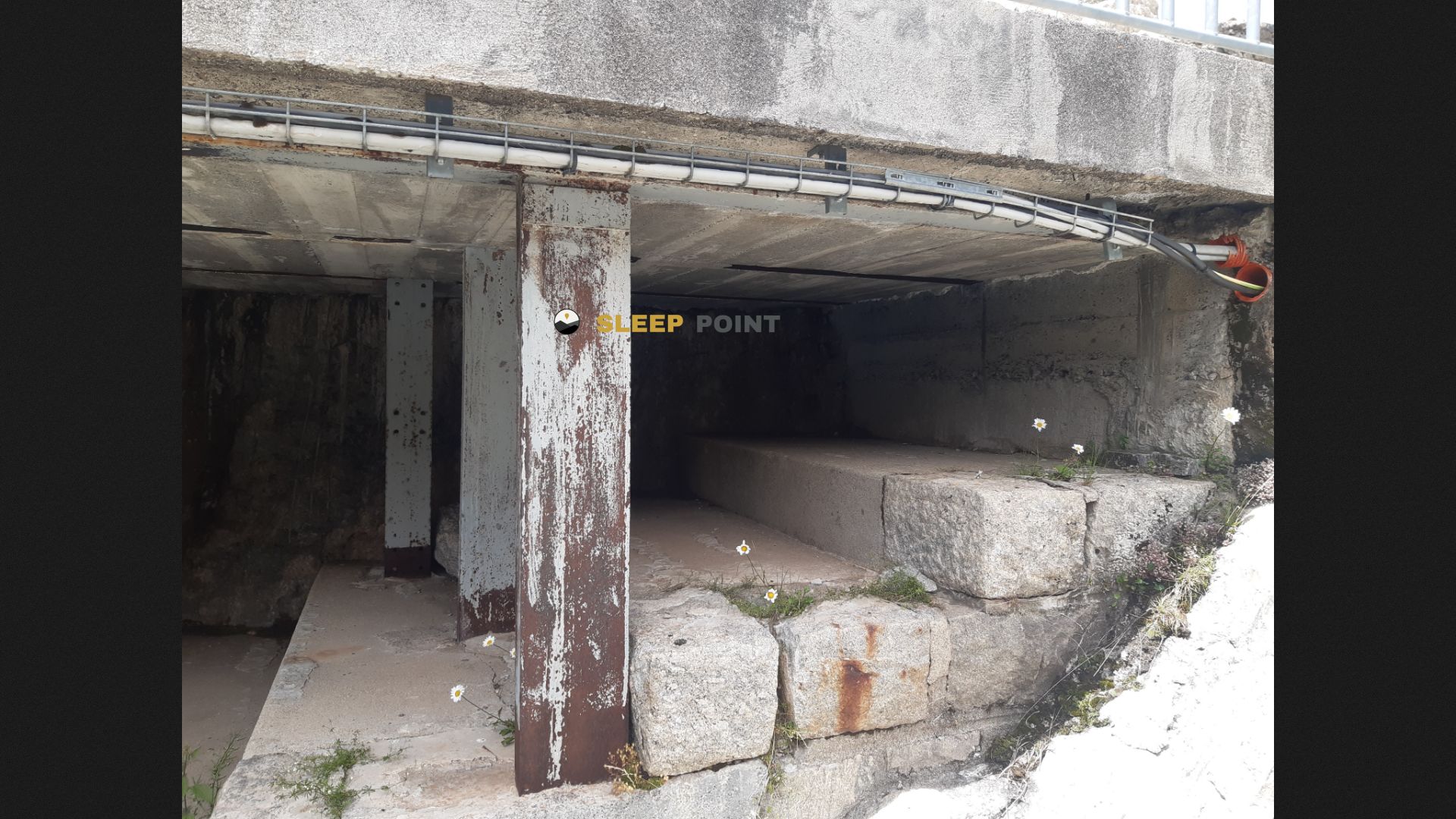
On the French side of the central Pyrenees, this cabin is left on a liaison ground. By 2020 meters, the Cabane de Prat-Cazeneuve ou Aygues Tortes is located in the surroundings of Loudenvielle, on the route that ascends to the lac of Clarabide and Pouchergues. Its position helps to read the highlights of this part of the mountain range: a sector where the changes of the valley and of orientation make the progression very difficult, with a clearly mountainous environment and steps that can serve as a transition between nearby basins.

The interest of this mountain shelter is less in immediate access than in its role as support in a high and open area, specific to the solid struggle and the reliefs that link with areas of strong alpine character. In this context, references such as Spijeoles or the rails that descend to Estos, useful to place the shelter within a pirenaic strip where the cords separate French and aragonese sides. This geographical reading is practical for those who plan a long day, a cross of hills or a cross without depending on nearby infrastructure.

Logistics requires caution. There are no associated routes in the available data and there is no need for close water: the registered sources are more than 5.7 km away, too long to take on easy supply in the vicinity. That is why it is important to get there with sufficient autonomy and to review well mapping, weather and state of the ground before leaving. At this point, any change in the orientation of the valley can result in differences in snow, humidity or wind exposure, something relevant if the cabin is used as a guard within a high mountain planning.

Nearby water fountains

Fuente

5.74 Km
Lat: 0 Lon: 0

Fuente

5.89 Km
Lat: 0 Lon: 0

Fuente

6.87 Km
Lat: 0 Lon: 0

Fuente

7.36 Km
Lat: 0 Lon: 0

Fuente

8.6 Km
Lat: 0 Lon: 0

Fuente

9.97 Km
Lat: 0 Lon: 0
FAQ

Frequently asked questions

Pregunta frecuente
Are there other mountain refuges near Cabane de Prat-Cazeneuve Ou Aygues Tortes?
Yes, nearby you can find other options to spend the night or take shelter. El refugio más próximo es el Cabane de Prat-Cazeneuve, que se encuentra a aproximadamente 0 km de distancia.
Pregunta frecuente
At what exact altitude is the Cabane de Prat-Cazeneuve Ou Aygues Tortes refuge located?
The Cabane de Prat-Cazeneuve Ou Aygues Tortes refuge is located at an altitude of 2020 meters above sea level, in the natural surroundings of refuge de prat-cazeneuve ou d'aygues tortes, sentier du lac de clarabide à pouchergues, loudenvielle, bagnères-de-bigorre, altos pirineos, occitania, francia metropolitana, 65510, francia.
Pregunta frecuente
What are the GPS coordinates of the Cabane de Prat-Cazeneuve Ou Aygues Tortes refuge?
To locate the Cabane de Prat-Cazeneuve Ou Aygues Tortes refuge on your GPS or map, use the following coordinates: Latitude 42.704 and Longitude 0.438.
More areas

Other areas

Collaborative

Together we improve

image

Send your photos

You can upload photos of shelters and update their status so other users know if they can go there.

Get started
Get started
image

Rate the shelter

Leave your comments to rate the shelter’s condition. In the mountains, we look after each other.

Get started
Get started
image

Add new ones

Did we miss any? Publish the shelters you know so everyone can use them.

Get started
Get started
Download for free from the Apple App Store and Play Store.

Download the app and start looking for the shelter of your next adventure

Aplicación móvil para encontrar refugios de montaña donde dormir
Aplicación móvil para encontrar refugios de montaña donde dormir.
Mapa interactivo de refugios de montaña en los Pirineos dentro de la app
Mapa de refugios de montaña para senderismo y trekking en la app.
Pantalla con información de refugio de montaña con altitud capacidad y servicios
Pantalla con información de refugio de montaña con altitud capacidad y servicios.
Detalles de refugio de montaña con servicios y meteorología en aplicación móvil
Detalles de refugio de montaña con servicios y meteorología en aplicación móvil.
Aplicación para explorar refugios de montaña mediante mapa interactivo
Aplicación para explorar refugios de montaña mediante mapa interactivo.
Ficha completa de refugio de montaña con opiniones y servicios
Ficha completa de refugio de montaña con opiniones y servicios.
Información detallada de refugio en app para montañeros
Información detallada de refugio en app para montañeros.
Listado de refugios de montaña para senderismo y trekking
Listado de refugios de montaña para senderismo y trekking.
Explorar refugios de montaña desde una aplicación móvil
Explorar refugios de montaña desde una aplicación móvil.