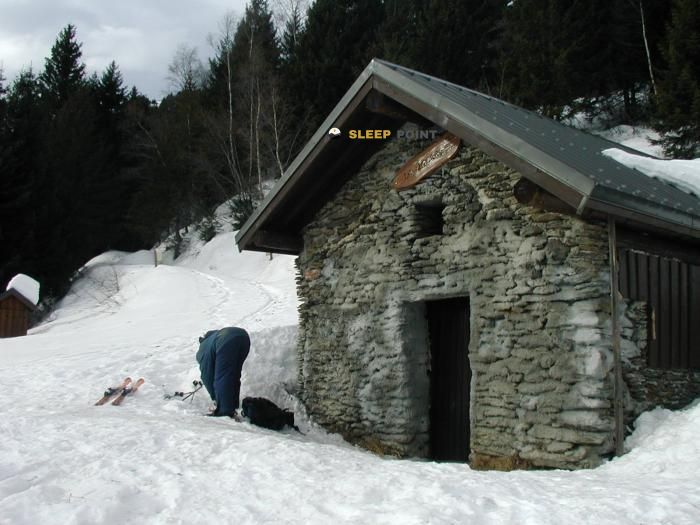
Mountain refuge Baraque à Michel
We have it listed in the app!
We have it listed in the app!


Prepare your backpack and head to baraque à michel, route des turchets, la frasse, bourget-en-huile, chambéry, saboya, auvergne-rhône-alpes, francia metropolitana, 73110, francia. There you will find the Baraque à Michel refuge at 1226 meters of elevation. An essential stop along the way (Lat: 45.476, Lon: 6.218) for any mountain enthusiast.
10.1°C
Feels like: 7.1°C7.2 km/h
Gusts: 15.1 km/h4050 m
Snow lineUV 0
Clouds: 99% 34.1 mm
 19.1 km/h
 UV máx: 4.6
 05:48
05:48
 21:18
0.6 mm
11.2 km/h
UV máx: 6.5
05:48
21:19
0 mm
9.3 km/h
UV máx: 7.6
05:47
21:20
0 mm
9.2 km/h
UV máx: 7.3
05:47
21:20
2.55 mm
8.3 km/h
UV máx: 6.8
05:47
21:21
6.3 mm
9.7 km/h
UV máx: 3.25
05:46
21:22
0 mm
7.6 km/h
UV máx: 7.4
05:46
21:22
21:18
0.6 mm
11.2 km/h
UV máx: 6.5
05:48
21:19
0 mm
9.3 km/h
UV máx: 7.6
05:47
21:20
0 mm
9.2 km/h
UV máx: 7.3
05:47
21:20
2.55 mm
8.3 km/h
UV máx: 6.8
05:47
21:21
6.3 mm
9.7 km/h
UV máx: 3.25
05:46
21:22
0 mm
7.6 km/h
UV máx: 7.4
05:46
21:22
Baraque à Michel appears on an average mountain level, at 1226 meters, within the Bourget-en-Huile Savoy. The approach moves in a relief of wooded slopes and cords that gain height towards nearby summits like Pic de la Loze , very close, or the axis that leads to Grand Chat and Pointe de Rognier . It is not a strict high mountain site, but it is a point where meteorology can change quickly and condition the day, especially with fog, rain or wind in the open parts.
Its practical interest is to serve as a reference for organizing the effort on long-distance hiking routes around the area. In this sector the Haute Traversée de Belledonne for GR 738 , so the shelter fits well as support to divide stages, adjust schedules or decide whether to continue to higher levels or keep room for a change of time. It can also be useful in connection routes through the massif, where fatigue management weighs as much as distance.
The environment combines middle forest mountains with exits to crest and summits that already require a more careful reading of the terrain. This transition makes it a good step in the search for a progressive day, starting with more protected paths and leaving the most exposed sections behind. If the day comes unstable, its moderate altitude allows to assess on the ground whether it is worth continuing to gain height.
In the logistics we should keep the water in mind. There are relatively close sources, with several located less than a kilometre away, but in mountain it is not enough to foresee sufficient autonomy and confirm flows according to time and conditions. For those who plan hiking in this part of Savoy, the shelter works mainly as a point of support and decision, rather than as a simple end of the walk.


📏 0.7 Km
⛰️ 1470 m

📏 1.2 Km
⛰️ 1235 m

📏 1.7 Km
⛰️ 990 m

📏 1.9 Km
⛰️ 1425 m
📏 2.1 Km
⛰️ 1567 m

📏 3.3 Km
⛰️ 1695 m

📏 4 Km
⛰️ 1450 m

📏 4.1 Km
⛰️ 1465 m
Download the app and start looking for the shelter of your next adventure


Find a place to sleep before night falls.


