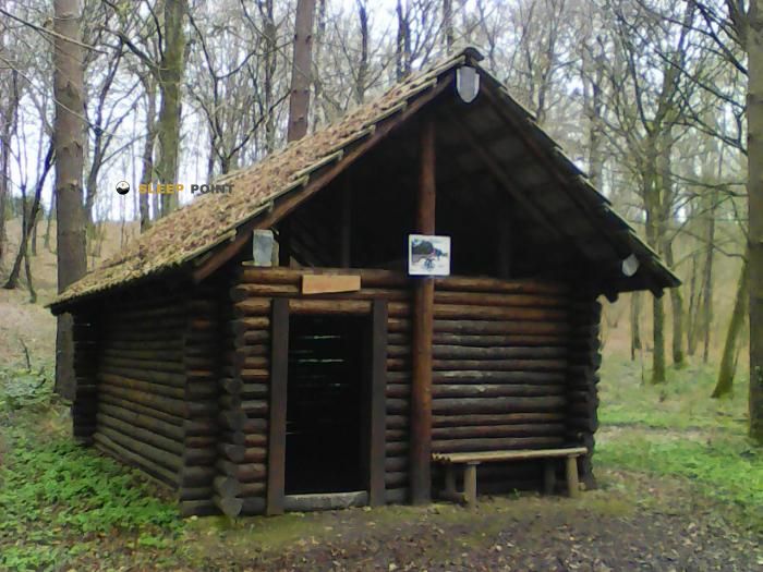
Mountain refuge Baccu du Chien Pendu
We have it listed in the app!
We have it listed in the app!


At 244 meters above sea level, nestled in route forestière du chien pendu, falletans, dole, jura, borgoña-franco condado, francia metropolitana, 39700, francia, stands the Baccu du Chien Pendu refuge. It is the perfect stop to spend the night or catch your breath. GPS coordinates: 47.073, 5.567.
14.9°C
Feels like: 13.8°C9.4 km/h
Gusts: 20.9 km/h3640 m
Snow lineUV 0
Clouds: 100% 21.6 mm
 21.9 km/h
 UV máx: 3.1
 05:44
05:44
 21:27
0.1 mm
11.8 km/h
UV máx: 6.4
05:44
21:28
0 mm
16.7 km/h
UV máx: 7.1
05:43
21:29
0 mm
8.7 km/h
UV máx: 6.15
05:43
21:30
3.3 mm
10.9 km/h
UV máx: 5.9
05:42
21:30
22.8 mm
13.8 km/h
UV máx: 6.4
05:42
21:31
0 mm
14 km/h
UV máx: 6.9
05:42
21:32
21:27
0.1 mm
11.8 km/h
UV máx: 6.4
05:44
21:28
0 mm
16.7 km/h
UV máx: 7.1
05:43
21:29
0 mm
8.7 km/h
UV máx: 6.15
05:43
21:30
3.3 mm
10.9 km/h
UV máx: 5.9
05:42
21:30
22.8 mm
13.8 km/h
UV máx: 6.4
05:42
21:31
0 mm
14 km/h
UV máx: 6.9
05:42
21:32
In the Falletans sector, within the Borgoña- Franco Condado region, the forest landscape imposes its own rules of progression. The altitude is maintained at discrete levels but the environment is complex. The main limitation for the mountain is the scarcity of surface water. The cartographed sources are located several kilometres away from the shelter. This conditions the logistics of any overnight or long stop. It is imperative to ensure water supply before entering the tree mass. Total autonomy is the essential requirement for using this support point.
The surrounding terrain lacks large geographical milestones or reference summits. The navigation is based exclusively on the tracking of signposted tracks and paths. Orientation changes are common and may disorient in fog or rain conditions. The Baccu du Chien Pendu is protected between the dense vegetation of the Jura. Itineraries like the Circuit des Pins Noirs and Sentier du Guêpier offer tours of different intensity. The march is fluid but the monotony of the forest requires attention to the map. In Réseau pédestre du Grand Dole , the road crosses happen quickly.
This shelter acts as a link node for larger cross-ships. Its location is strategic for those who travel through the Sentier des radeliers , a tour of more than 20 kilometers. It also facilitates access to variants of GR 59A in his way through the County Franco. Isolation from the usual mountain transit is one of its main features. In situations of adverse weather, it provides a dry and solid shelter. No specific services, heating or furniture should be available without prior verification. The structure serves as an operational basis for exploring the area of Brevans and its brotherly surroundings. Planning must be rigorous in the absence of close supplies.


📏 2.6 Km
⛰️ 254 m
📏 3.6 Km
⛰️ 208 m

📏 6 Km
⛰️ 239 m

📏 6.2 Km
⛰️ 206 m

📏 10 Km
⛰️ 260 m

📏 10.5 Km
⛰️ 258 m

📏 11.2 Km
⛰️ 348 m

📏 11.5 Km
⛰️ 257 m
Download the app and start looking for the shelter of your next adventure


Find a place to sleep before night falls.


