Mountain refuge Baccu de la Fontaine du Moret

We have it listed in the app!


            Mountain refuge Baccu de la Fontaine du Moret in baccu de la fontaine du moret, route des italiens, la loye, dole, jura, borgoña-franco condado, francia metropolitana, 39380, francia
Five orange stars in a horizontal row representing a five-star rating.

Baccu de la Fontaine du Moret

Lat: 47.041xxx – Lon: 5.557xxx
📍 baccu de la fontaine du moret, route des italiens, la loye, dole, jura, borgoña-franco condado, francia metropolitana, 39380, francia
Baccu de la Fontaine du Moret

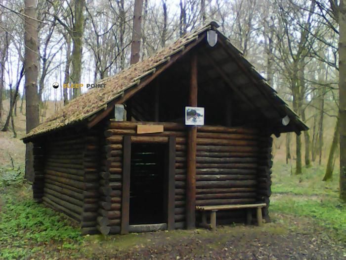
The Baccu de la Fontaine du Moret refuge (baccu de la fontaine du moret, route des italiens, la loye, dole, jura, borgoña-franco condado, francia metropolitana, 39380, francia) is a classic meeting point for mountaineers and hikers. At 208 meters, its coordinates 47.041, 5.557 mark the end of a stage or the beginning of a new adventure.

See more
See more
Usuario

Lucas Martinez

Premium user

Live weather: Baccu de la Fontaine du Moret

Alpine weather summary for Baccu de la Fontaine du Moret: temperature at 16.6°C, feels like 15°C. Wind at 11.6 km/h with peaks of 23 km/h. UV index at 0 and freezing altitude at 3830 m. Maximum temperatures of 19.4°C in the coming hours.
Temperature

16.6°C

Feels like: 15°C
Wind

11.6 km/h

Gusts: 23 km/h
Freezing level 0°

3830 m

Snow line
Sky & UV

UV 0

Clouds: 100%

Next 48 hours evolution

7-day forecast

03/06
19.4° 12.8°
7.7 mm 15 km/h UV máx: 6.9
05:45 21:26
04/06
18.9° 13.6°
12.7 mm 19.2 km/h UV máx: 2.45
05:44 21:27
05/06
19.6° 11.2°
0 mm 12.1 km/h UV máx: 6.65
05:44 21:28
06/06
23.5° 11.7°
0.6 mm 16.2 km/h UV máx: 7.1
05:43 21:29
07/06
23.2° 11.4°
0 mm 6.4 km/h UV máx: 6.25
05:43 21:29
08/06
27.7° 12.2°
0 mm 12.6 km/h UV máx: 7
05:43 21:30
09/06
20.6° 14.5°
22.2 mm 14.2 km/h UV máx: 5.75
05:42 21:31

The shelter is located in the department of Jura. It is located in the commune of La Loye. Its altitude is 208 meters. This point links different sectors near Dole. The construction is at the Route des Italiens. It's a reference to transit through Burgundy-Franco County. Its position connects basins and forest areas. It's a node on the Grand Dole network. The relief is soft. The environment is forest. There are no summits nearby. The orientation requires using the map. The forest tracks are numerous. Attention must be paid to the course. The land is flat but dense in vegetation. The visibility is limited by the trees. The mental map must be clear before entering the forest.

Several long-range itineraries cross this sector. The Sentier des radeliers is passing by. Also access to GR 59A. The Baccu de la Fontaine du Moret is on Via Cluny. It offers basic logistical support. Planning must be strict with water. There are no sources near the building. The water points are very far away. We have to carry enough supplies. Self-government is compulsory. The team must be complete. It is appropriate to ensure the state of the shelter before. The responsibility lies with the user. This free space allows you to rest on the road. It's a technical stop point. It has no foster services. Prepreparation is the key to success. The senator must be self-sufficient at all times.

Hiking routes from the refuge

Local

Sentier des radeliers

↔ 20.8 km
Local

Réseau pédestre du Grand Dole

↔ Variable distance
GR 59A

Accès GR 59

↔ Variable distance
Local

Via Cluny variante Dole Etape 1

↔ 30 km

Nearby water fountains

Fuente

6.59 Km
Lat: 0 Lon: 0

Fuente

6.91 Km
Lat: 0 Lon: 0

Fuente

7.27 Km
Lat: 0 Lon: 0

Fuente

7.36 Km
Lat: 0 Lon: 0

Fuente

7.48 Km
Lat: 0 Lon: 0

Fuente

7.64 Km
Lat: 0 Lon: 0

Fuente

8.66 Km
Lat: 0 Lon: 0

Fuente

9.32 Km
Lat: 0 Lon: 0
FAQ

Frequently asked questions

Pregunta frecuente
At what exact altitude is the Baccu de la Fontaine du Moret refuge located?
The Baccu de la Fontaine du Moret refuge is located at an altitude of 208 meters above sea level, in the natural surroundings of baccu de la fontaine du moret, route des italiens, la loye, dole, jura, borgoña-franco condado, francia metropolitana, 39380, francia.
Pregunta frecuente
What are the GPS coordinates of the Baccu de la Fontaine du Moret refuge?
To locate the Baccu de la Fontaine du Moret refuge on your GPS or map, use the following coordinates: Latitude 47.041 and Longitude 5.557.
Pregunta frecuente
Is it necessary to carry a GPS to reach the Baccu de la Fontaine du Moret refuge?
It is always highly recommended to carry a GPS device, a route track, or a topographic map in the mountains. You can use the coordinates 47.041, 5.557 to locate this refuge precisely.
More areas

Other areas

Collaborative

Together we improve

image

Send your photos

You can upload photos of shelters and update their status so other users know if they can go there.

Get started
Get started
image

Rate the shelter

Leave your comments to rate the shelter’s condition. In the mountains, we look after each other.

Get started
Get started
image

Add new ones

Did we miss any? Publish the shelters you know so everyone can use them.

Get started
Get started
Download for free from the Apple App Store and Play Store.

Download the app and start looking for the shelter of your next adventure

Aplicación móvil para encontrar refugios de montaña donde dormir
Aplicación móvil para encontrar refugios de montaña donde dormir.
Mapa interactivo de refugios de montaña en los Pirineos dentro de la app
Mapa de refugios de montaña para senderismo y trekking en la app.
Pantalla con información de refugio de montaña con altitud capacidad y servicios
Pantalla con información de refugio de montaña con altitud capacidad y servicios.
Detalles de refugio de montaña con servicios y meteorología en aplicación móvil
Detalles de refugio de montaña con servicios y meteorología en aplicación móvil.
Aplicación para explorar refugios de montaña mediante mapa interactivo
Aplicación para explorar refugios de montaña mediante mapa interactivo.
Ficha completa de refugio de montaña con opiniones y servicios
Ficha completa de refugio de montaña con opiniones y servicios.
Información detallada de refugio en app para montañeros
Información detallada de refugio en app para montañeros.
Listado de refugios de montaña para senderismo y trekking
Listado de refugios de montaña para senderismo y trekking.
Explorar refugios de montaña desde una aplicación móvil
Explorar refugios de montaña desde una aplicación móvil.