Mountain refuge Abri du col du Petit Ballon

We have it listed in the app!


            Mountain refuge Abri du col du Petit Ballon in sentier Émile hertzog, luttenbach-près-munster, colmar-ribeauvillé, alto rin, gran este, francia metropolitana, 68230, francia
Five orange stars in a horizontal row representing a five-star rating.

Abri du col du Petit Ballon

Lat: 47.986xxx – Lon: 7.12xxx
📍 sentier Émile hertzog, luttenbach-près-munster, colmar-ribeauvillé, alto rin, gran este, francia metropolitana, 68230, francia
Abri du col du Petit Ballon

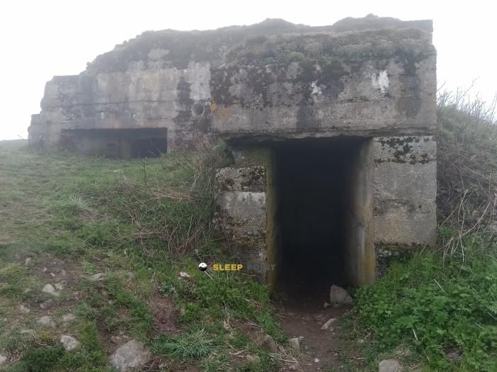
Strategically located in sentier Émile hertzog, luttenbach-près-munster, colmar-ribeauvillé, alto rin, gran este, francia metropolitana, 68230, francia, the Abri du col du Petit Ballon refuge makes exploring the area easier. At 1170 meters above sea level, this point of interest (47.986, 7.12) is a vital resource when planning your route.

See more
See more
Usuario

Lucas Martinez

Premium user

Live weather: Abri du col du Petit Ballon

With 96% cloud coverage, the Abri du col du Petit Ballon shelter reports 11.1°C and a feels-like temperature of 6.3°C. Breeze at 25.5 km/h with possible gusts of 88.2 km/h. The freezing altitude is at 3310 m and the maximum will reach 12.7°C.
Temperature

11.1°C

Feels like: 6.3°C
Wind

25.5 km/h

Gusts: 88.2 km/h
Freezing level 0°

3310 m

Snow line
Sky & UV

UV 0

Clouds: 96%

Next 48 hours evolution

7-day forecast

03/06
12.7° 7.6°
1.5 mm 25.6 km/h UV máx: 5.05
05:35 21:24
04/06
13.6° 8.9°
5.7 mm 33.7 km/h UV máx: 5.25
05:34 21:25
05/06
12.7° 7.3°
0 mm 27.4 km/h UV máx: 6.7
05:34 21:26
06/06
14.4° 7.6°
1.1 mm 15.8 km/h UV máx: 7.05
05:33 21:26
07/06
16.2°
0 mm 17.3 km/h UV máx: 6.35
05:33 21:27
08/06
22.3° 8.9°
0 mm 6.7 km/h UV máx: 6.85
05:32 21:28
09/06
14.2°
5.4 mm 17.3 km/h UV máx: 6.2
05:32 21:29

In the surroundings of Luttenbach-près-Munster, over the passage of the Petit Ballon and at 1170 meters of altitude, this coat fits better in a logic of passage and guard than in that of a simple short stop. The height already places it in a mountain where the wind, fog and time changes can make the day very much conditioned, even on itineraries without high alpine altitude. Its position also relates it to the direction axis of the high Vosgos and to routes linking hills, lomas and forests of medium and high mountains.

The main utility of Abri du col du Petit Ballon is in its role within long routes or chained days. Very close pass the GR 5 , GR 532 , GR 531 and the Sentier Émile Hertzog, as well as local circuits such as Narrenstein or the Cascade du Seebach path. This makes it a reasonable point to divide stage, expect a weather improvement or have a withdrawal option if conditions get worse in the cords.

The terrain of this area often requires more attention for continuity, orientation and exposure than for technicality. On closed days, high hills and highways can easily lose references, and a coat like this gains value as logistical support. It can also be used to reorganize a day if several signposted routes are linked and progress is slower than expected.

It is appropriate to plan autonomy with margin. The nearest registered source is about 2.33 km, and the others clearly exceed that distance, so it is not wise to have immediate water next to the coat. If the stage depends on the on-road revival, it is worth reviewing first where to load water and not taking for granted that there will be continuous availability on the laundry.

In the absence of useful data on nearby summits, the interest of the place is less in serving as a basis for ascension and more in its role of passage and refuge in a network of long-distance trails. For those who go through this sector of the French Greater East, its value lies in stage planning, time management and the ability to adapt to the weather of the day.

Hiking routes from the refuge

GR 5

GR 5 Vosges, Le Donon - Ballon d'Alsace

↔ Variable distance
Local

Circuit Narrenstein

↔ Variable distance
GR 532

GR 532

↔ 503 km
Local

Sentier Emile Hertzog

↔ Variable distance
GR 531

GR 531

↔ 376 km
Local

Sentier de la Cascade du Seebach

↔ Variable distance
CCFA

Chemin des Châteaux forts d'Alsace

↔ 450 km
Local

Tour du Petit Ballon

↔ Variable distance

Nearby water fountains

Fuente

2.33 Km
Lat: 0 Lon: 0

Fuente

3.56 Km
Lat: 0 Lon: 0

Fuente

3.65 Km
Lat: 0 Lon: 0

Fuente

3.78 Km
Lat: 0 Lon: 0

Fuente

3.86 Km
Lat: 0 Lon: 0

Fuente

4 Km
Lat: 0 Lon: 0

Fuente

4.01 Km
Lat: 0 Lon: 0

Fuente

4.05 Km
Lat: 0 Lon: 0
FAQ

Frequently asked questions

Pregunta frecuente
At what exact altitude is the Abri du col du Petit Ballon refuge located?
The Abri du col du Petit Ballon refuge is located at an altitude of 1170 meters above sea level, in the natural surroundings of sentier Émile hertzog, luttenbach-près-munster, colmar-ribeauvillé, alto rin, gran este, francia metropolitana, 68230, francia.
Pregunta frecuente
What are the GPS coordinates of the Abri du col du Petit Ballon refuge?
To locate the Abri du col du Petit Ballon refuge on your GPS or map, use the following coordinates: Latitude 47.986 and Longitude 7.12.
Pregunta frecuente
Is it necessary to carry a GPS to reach the Abri du col du Petit Ballon refuge?
It is always highly recommended to carry a GPS device, a route track, or a topographic map in the mountains. You can use the coordinates 47.986, 7.12 to locate this refuge precisely.
More areas

Other areas

Collaborative

Together we improve

image

Send your photos

You can upload photos of shelters and update their status so other users know if they can go there.

Get started
Get started
image

Rate the shelter

Leave your comments to rate the shelter’s condition. In the mountains, we look after each other.

Get started
Get started
image

Add new ones

Did we miss any? Publish the shelters you know so everyone can use them.

Get started
Get started
Download for free from the Apple App Store and Play Store.

Download the app and start looking for the shelter of your next adventure

Aplicación móvil para encontrar refugios de montaña donde dormir
Aplicación móvil para encontrar refugios de montaña donde dormir.
Mapa interactivo de refugios de montaña en los Pirineos dentro de la app
Mapa de refugios de montaña para senderismo y trekking en la app.
Pantalla con información de refugio de montaña con altitud capacidad y servicios
Pantalla con información de refugio de montaña con altitud capacidad y servicios.
Detalles de refugio de montaña con servicios y meteorología en aplicación móvil
Detalles de refugio de montaña con servicios y meteorología en aplicación móvil.
Aplicación para explorar refugios de montaña mediante mapa interactivo
Aplicación para explorar refugios de montaña mediante mapa interactivo.
Ficha completa de refugio de montaña con opiniones y servicios
Ficha completa de refugio de montaña con opiniones y servicios.
Información detallada de refugio en app para montañeros
Información detallada de refugio en app para montañeros.
Listado de refugios de montaña para senderismo y trekking
Listado de refugios de montaña para senderismo y trekking.
Explorar refugios de montaña desde una aplicación móvil
Explorar refugios de montaña desde una aplicación móvil.