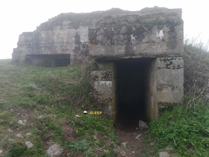
Mountain refuge Ferme-auberge Wassmatt
We have it listed in the app!
We have it listed in the app!

Protected by the wild surroundings of ferme auberge wassmatt, 134, chemin de l'abri de montagne, wasserbourg, colmar-ribeauvillé, alto rin, gran este, francia metropolitana, 68230, francia, the Ferme-auberge Wassmatt refuge is your best ally at 840 meters of elevation. Once you reach its coordinates (47.994, 7.137), you can enjoy a well-deserved mountain rest.
12.6°C
Feels like: 9.7°C17.3 km/h
Gusts: 51.5 km/h3530 m
Snow lineUV 0.4
Clouds: 100% 1.5 mm
 25.6 km/h
 UV máx: 5.05
 05:34
05:34
 21:24
8.1 mm
35.6 km/h
UV máx: 5.25
05:34
21:25
1.3 mm
24.3 km/h
UV máx: 6.7
05:33
21:26
0.9 mm
12.9 km/h
UV máx: 7.05
05:33
21:26
0 mm
12.8 km/h
UV máx: 6.35
05:33
21:27
0 mm
7.2 km/h
UV máx: 6.85
05:32
21:28
5.4 mm
17.3 km/h
UV máx: 6.2
05:32
21:29
21:24
8.1 mm
35.6 km/h
UV máx: 5.25
05:34
21:25
1.3 mm
24.3 km/h
UV máx: 6.7
05:33
21:26
0.9 mm
12.9 km/h
UV máx: 7.05
05:33
21:26
0 mm
12.8 km/h
UV máx: 6.35
05:33
21:27
0 mm
7.2 km/h
UV máx: 6.85
05:32
21:28
5.4 mm
17.3 km/h
UV máx: 6.2
05:32
21:29
The Ferme-auberge Wassmatt , in the Wasserbourg area and within the Alsatian High Rhine, it is 840 metres in a half-mountain strip where time changes quickly and the relief begins to open to higher summits. It is not a valley-bottom site: its position is closer to areas more exposed to the wind, the fog and the changes of visibility, something important for those who plan a long day or a journey through the Vosgos.
Its mountain interest is in supporting itineraries that link looms, hills and nearby peaks. From this area the proximity of the Petit Ballon , less than 2 km in a straight line and above 1,270 metres, along with other heights such as Hilsenfirst or Langenfeldkopf, which reinforce the character of an undulating but wide mountain, without the typical fitting of a closed valley. It also fits as an intermediate point for those who move along signposted long-range routes, with the GR 5 and GR 532 as useful references in the sector.
Access and demand depend very much on the chosen route, but it is necessary to have sustained levels and sections where the orientation is complicated if it enters low cloud. In this type of relief, the reading of the land and the divisives is more important than technical difficulty. That is why, rather than an isolated ascension base, it works better as support for days linked between summits and crest roads.
In logistics, water should not be taken for granted in the immediate environment itself. The nearest registered source is close to 2 km, a distance sufficient to go out with autonomy and review the supply before the route. The combination of moderate altitude, exposure and network of trails makes it advisable to adjust well load, water and weather forecast.


📏 1.2 Km
⛰️ 1100 m

📏 1.6 Km
⛰️ 814 m
📏 1.6 Km
⛰️ 1170 m

📏 1.9 Km
⛰️ 1131 m

📏 1.9 Km
⛰️ 1200 m

📏 2.3 Km
⛰️ 1130 m

📏 3.2 Km
⛰️ 640 m

📏 4.7 Km
⛰️ 1071 m
Download the app and start looking for the shelter of your next adventure


Find a place to sleep before night falls.


