Mountain refuge Abri de l'arboretum

We have it listed in the app!


            Mountain refuge Abri de l'arboretum in chemin du larmont, l'arcan, larmont - saint-Étienne, pontarlier, doubs, borgoña-franco condado, francia metropolitana, 25300, francia
Five orange stars in a horizontal row representing a five-star rating.

Abri de l'arboretum

Lat: 46.898xxx – Lon: 6.379xxx
📍 chemin du larmont, l'arcan, larmont - saint-Étienne, pontarlier, doubs, borgoña-franco condado, francia metropolitana, 25300, francia
Abri de l'arboretum

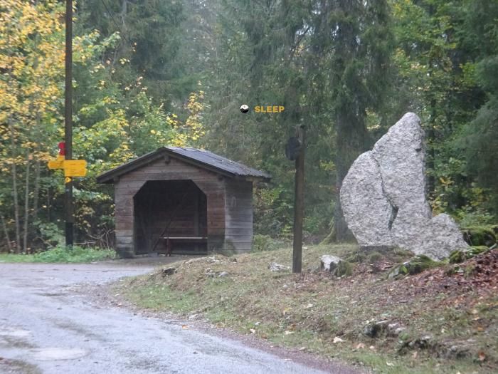
The Abri de l'arboretum refuge (chemin du larmont, l'arcan, larmont - saint-Étienne, pontarlier, doubs, borgoña-franco condado, francia metropolitana, 25300, francia) is a classic meeting point for mountaineers and hikers. At 958 meters, its coordinates 46.898, 6.379 mark the end of a stage or the beginning of a new adventure.

See more
See more
Usuario

Lucas Martinez

Premium user

Live weather: Abri de l'arboretum

Before heading to Abri de l'arboretum, check the weather: we currently have 11.8°C (feels like 9.1°C). With wind gusts reaching 24.1 km/h and a freezing level around 3860 meters, the daytime high will not exceed 14.6°C.
Temperature

11.8°C

Feels like: 9.1°C
Wind

12 km/h

Gusts: 24.1 km/h
Freezing level 0°

3860 m

Snow line
Sky & UV

UV 0

Clouds: 100%

Next 48 hours evolution

7-day forecast

04/06
14.6° 9.8°
12.2 mm 19.1 km/h UV máx: 5.6
05:42 21:23
05/06
13.4°
3.1 mm 13.7 km/h UV máx: 7
05:41 21:24
06/06
17.4° 7.1°
0 mm 19.1 km/h UV máx: 7.25
05:41 21:25
07/06
17.7° 8.5°
0 mm 10.7 km/h UV máx: 6.4
05:40 21:26
08/06
21.2° 10.4°
5.4 mm 11.5 km/h UV máx: 6.8
05:40 21:26
09/06
15.3° 9.2°
12.9 mm 18.4 km/h UV máx: 3.95
05:40 21:27
10/06
18.6° 5.2°
0 mm 11.5 km/h UV máx: 7.15
05:39 21:28

The routes across the Pontarlier environment include long-drawn routes such as Via Francigena and GR 5 Jura , along with local trails that move along the Jura massif and the slopes of the Larmont sector. In that context, Abri de l'arboretum , at 958 meters, it fits mainly as a support coat or withdrawal point if the day is complicated by meteorology, tiredness or the need to shorten a stage. It does not stand out for a high altitude, but for its practical utility in a half-mountain area where the routes can be extended and linked several possible directions.

The environment combines forest relief and Jurasian mountain near the Swiss border, with clear references such as Le Grand Taureau , which dominates the area from 1,323 meters. For those who plan a journey or a long exit, this coat can serve to divide the route, reorganize the march, or have an intermediate reference near the path. There is a source located about 1.77 km, a reasonable distance but sufficient to not solve the water without prior forecast, especially if it is arrived late or under variable conditions. As is the case in many shelters and basic walking coats, it is appropriate to propose the day with autonomy, time margin and a careful reading of the terrain, especially if it is intended to link long routes or use it as a basis for moving to nearby levels of the Jura.

Hiking routes from the refuge

7

Sentier du Tour du Lac

↔ Variable distance
4

Le sentier montagnard du Grand Taureau

↔ Variable distance
Local

Combasson-Petit Cernets

↔ Variable distance
GR 145

Via Francigena - part France - 04 Besançon - frontière

↔ Variable distance
GR 5

GR 5 Jura

↔ Variable distance
GR5-VAR-MORTEAU

GR 5 Variante Morteau

↔ Variable distance
1

Les Grands Communaux

↔ Variable distance
5

La Pierre qui Tourne

↔ Variable distance

Nearby peaks

Le Grand Taureau

1323 m
Lat: 46.9147 Lon: 6.43

Le Crossat

1003 m
Lat: 46.8542 Lon: 6.3565

Crêt de la Rappe

Altitude not available
Lat: 46.9347 Lon: 6.3516

Bémont

Altitude not available
Lat: 46.9498 Lon: 6.3676

le Gérot

Altitude not available
Lat: 46.8688 Lon: 6.3692

Nearby water fountains

Fuente

1.77 Km
Lat: 46.8688 Lon: 6.3692

Fuente

2.88 Km
Lat: 46.8688 Lon: 6.3692

Fuente

4.01 Km
Lat: 46.8688 Lon: 6.3692

Fuente

5.6 Km
Lat: 46.8688 Lon: 6.3692

Fuente

6.32 Km
Lat: 46.8688 Lon: 6.3692

Fuente

7.15 Km
Lat: 46.8688 Lon: 6.3692

Fuente

7.97 Km
Lat: 46.8688 Lon: 6.3692

Fuente

8.22 Km
Lat: 46.8688 Lon: 6.3692
FAQ

Frequently asked questions

Pregunta frecuente
Are there other mountain refuges near Abri de l'arboretum?
Yes, nearby you can find other options to spend the night or take shelter. El refugio más próximo es el Le Gounefay, que se encuentra a aproximadamente 1.9 km de distancia.
Pregunta frecuente
At what exact altitude is the Abri de l'arboretum refuge located?
The Abri de l'arboretum refuge is located at an altitude of 958 meters above sea level, in the natural surroundings of chemin du larmont, l'arcan, larmont - saint-Étienne, pontarlier, doubs, borgoña-franco condado, francia metropolitana, 25300, francia.
Pregunta frecuente
What are the GPS coordinates of the Abri de l'arboretum refuge?
To locate the Abri de l'arboretum refuge on your GPS or map, use the following coordinates: Latitude 46.898 and Longitude 6.379.
More areas

Other areas

Collaborative

Together we improve

image

Send your photos

You can upload photos of shelters and update their status so other users know if they can go there.

Get started
Get started
image

Rate the shelter

Leave your comments to rate the shelter’s condition. In the mountains, we look after each other.

Get started
Get started
image

Add new ones

Did we miss any? Publish the shelters you know so everyone can use them.

Get started
Get started
Download for free from the Apple App Store and Play Store.

Download the app and start looking for the shelter of your next adventure

Aplicación móvil para encontrar refugios de montaña donde dormir
Aplicación móvil para encontrar refugios de montaña donde dormir.
Mapa interactivo de refugios de montaña en los Pirineos dentro de la app
Mapa de refugios de montaña para senderismo y trekking en la app.
Pantalla con información de refugio de montaña con altitud capacidad y servicios
Pantalla con información de refugio de montaña con altitud capacidad y servicios.
Detalles de refugio de montaña con servicios y meteorología en aplicación móvil
Detalles de refugio de montaña con servicios y meteorología en aplicación móvil.
Aplicación para explorar refugios de montaña mediante mapa interactivo
Aplicación para explorar refugios de montaña mediante mapa interactivo.
Ficha completa de refugio de montaña con opiniones y servicios
Ficha completa de refugio de montaña con opiniones y servicios.
Información detallada de refugio en app para montañeros
Información detallada de refugio en app para montañeros.
Listado de refugios de montaña para senderismo y trekking
Listado de refugios de montaña para senderismo y trekking.
Explorar refugios de montaña desde una aplicación móvil
Explorar refugios de montaña desde una aplicación móvil.