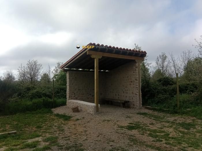
Mountain refuge Abri de Cuatro Caminos
We have it listed in the app!
We have it listed in the app!


Protected by the wild surroundings of camino de santiago, ventosa, la rioja, 26371, españa, the Abri de Cuatro Caminos refuge is your best ally at 625 meters of elevation. Once you reach its coordinates (42.411, -2.635), you can enjoy a well-deserved mountain rest.
15.8°C
Feels like: 15.9°C6.8 km/h
Gusts: 16.6 km/h3950 m
Snow lineUV 1.8
Clouds: 100% 1.88 mm
 16.8 km/h
 UV máx: 5.85
 06:34
06:34
 21:42
0 mm
12.3 km/h
UV máx: 7.15
06:34
21:43
0 mm
19.8 km/h
UV máx: 7.8
06:34
21:44
0 mm
15.6 km/h
UV máx: 7.85
06:33
21:45
0 mm
22.3 km/h
UV máx: 7.8
06:33
21:45
1.2 mm
15.6 km/h
UV máx: 7.1
06:33
21:46
0 mm
11.3 km/h
UV máx: 7.6
06:33
21:46
21:42
0 mm
12.3 km/h
UV máx: 7.15
06:34
21:43
0 mm
19.8 km/h
UV máx: 7.8
06:34
21:44
0 mm
15.6 km/h
UV máx: 7.85
06:33
21:45
0 mm
22.3 km/h
UV máx: 7.8
06:33
21:45
1.2 mm
15.6 km/h
UV máx: 7.1
06:33
21:46
0 mm
11.3 km/h
UV máx: 7.6
06:33
21:46
West of Window in the riojan corridor by which the French Road , Abri de Cuatro Caminos It fits better as a point of passage than as a high mountain shelter. Its position helps to focus on soft lomas, open roads and small elevations that order the land around the municipality, within an area where the main reference is not a circus or an alpine cordal, but the network of itineraries that crosses La Rioja from east to west.
This crossing character is well understood by the closeness of long-distance paths. In addition to the Jacobeo layout, variants of the road itself and other axes such as the GR 99 , linked to Ebro, or GR 120 . Rather than serve to raise ascent, this coat makes sense for those who move by linking days on foot and needs an intermediate reference on a transition ground between fields, hills and historical roads.
The altitude, 625 meters, places the whole in a modest level, far from the atmosphere of the alpine Pyrenees. Even so, the nearby relief provides useful references to read the map: the hill of the church of San Saturnino in Ventosa marks well the core of the village, while nearby elevations such as Cuento or El Espinal help to fit the local orientation and the succession of loins surrounding this part of La Rioja.
In the logistics, it is worth assessing that there is a source less than a kilometre, although on walking routes it is always wise to provide basic autonomy and not to depend on a single point of water without checking its state. The presence of more sources in the environment reinforces the idea of a relatively humanized area, but does not replace planning.
Because of its location and the type of routes around it, mountain access here is more related to the orientation between roads and communal references than to technical terrain. Even so, in long days of journey, with heat, wind or bad visibility, a coat of these characteristics still has value as a point guard within a very busy sector of the western riojan.


📏 4.3 Km
⛰️ 560 m

📏 16.2 Km
⛰️ 550 m
📏 20.1 Km
⛰️ 690 m

📏 29.6 Km
⛰️ 490 m

📏 30.2 Km
⛰️ 545 m

📏 31.2 Km
⛰️ 675 m

📏 36.1 Km
⛰️ 1543 m

📏 44.1 Km
⛰️ 1121 m
Download the app and start looking for the shelter of your next adventure


Find a place to sleep before night falls.


