Mountain refuge Abri de Bastroncelos

We have it listed in the app!


            Mountain refuge Abri de Bastroncelos in camino de santiago francés, ciriñuela, cirueña, la rioja, 26258, españa
Five orange stars in a horizontal row representing a five-star rating.

Abri de Bastroncelos

Lat: 42.422xxx – Lon: -2.879xxx
📍 camino de santiago francés, ciriñuela, cirueña, la rioja, 26258, españa
Abri de Bastroncelos

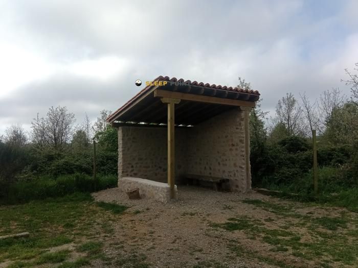
With a privileged location in camino de santiago francés, ciriñuela, cirueña, la rioja, 26258, españa, the Abri de Bastroncelos refuge awaits you at 690 meters of altitude. Note its position (42.422, -2.879) before starting your route through the mountain range or massif.

See more
See more
Usuario

Lucas Martinez

Premium user

Live weather: Abri de Bastroncelos

Alpine weather summary for Abri de Bastroncelos: temperature at 14.8°C, feels like 13.9°C. Wind at 10.5 km/h with peaks of 17.3 km/h. UV index at 0 and freezing altitude at 4550 m. Maximum temperatures of 17.8°C in the coming hours.
Temperature

14.8°C

Feels like: 13.9°C
Wind

10.5 km/h

Gusts: 17.3 km/h
Freezing level 0°

4550 m

Snow line
Sky & UV

UV 0

Clouds: 49%

Next 48 hours evolution

7-day forecast

04/06
17.8° 11.3°
0.2 mm 23.4 km/h UV máx: 6
06:35 21:44
05/06
21° 8.4°
0 mm 9.9 km/h UV máx: 7.15
06:35 21:44
06/06
23.5° 13°
0 mm 19.9 km/h UV máx: 7.05
06:35 21:45
07/06
25.9° 11.1°
0 mm 19.8 km/h UV máx: 7.9
06:34 21:46
08/06
17.9° 12.8°
0.9 mm 16.2 km/h UV máx: 8
06:34 21:46
09/06
16.8° 10.8°
0.3 mm 13.9 km/h UV máx: 5.15
06:34 21:47
10/06
22.2° 7.2°
0 mm 15.6 km/h UV máx: 7.6
06:34 21:47

Before having this coat in support, it is appropriate to propose the day with basic autonomy and to review the itinerary well. The Open of Bastronomy is located around 690 meters, in the surroundings of Surueña, within the Rioja Alta, a modest but open to changes of time, wind and mud according to the station. Its interest is not in an alpine environment, but in operating as a light guard within a passing area where long-distance roads are located.

The most clear geographical reference is the Camino de Santiago Francés , very close in this sector between Santo Domingo de la Calzada and the corridor that moves towards Burgos. This makes it a useful point for those who walk long stages and need intermediate support outside of the urban core. It also fits the logic of linking to the wider routes of La Rioja, such as the GR 93 of the Sierras Riojanas, although here the land responds more to the wavy landscape of the region than to a marked mountain.

The immediate environment combines wide roads, open fields and soft elevations, with nearby references such as Las Mesas, just above 700 meters. It is not an ascension shelter or a high mountain base, but a point of protection in a very walking transition strip, where the orientation often depends more on agricultural crosses, tracks and historical strands than on cords or hills.

In logistics, the most relevant data is the presence of a source within a few meters, in addition to other distributed in the nearby environment. Even so, the actual state of the water should always be confirmed in the course of the journey before it is dependent on it. The proximity to Surgeon and Santo Domingo de la Calzada helps to place it on the mental map of the area, but on the ground it is still recommended to carry sufficient water, shelter and planning.

Because of its location, this coat fits better with road trails than with summit mountaineers: those who advance in stages, those who link riojan roads or those who seek a simple guard on a long day. The practical utility of the place depends above all on this passing function and the ability to move with an autonomous criterion in an open and untechnical landscape.

Hiking routes from the refuge

Local

Camiño Francés (Rutas alternativas)

↔ 140 km
Local

Camino Francés - 03 Logroño a Burgos

↔ 750 km
GR 93

Sierras Riojanas

↔ Variable distance
Local

Camino de Santiago Vasco del Interior

↔ Variable distance

Nearby peaks

Las Mesas

712.40 m
Lat: 42.4417 Lon: -2.8462

Nearby water fountains

Fuente

15 m
Lat: 42.4417 Lon: -2.8462

Fuente

1.09 Km
Lat: 42.4417 Lon: -2.8462

Fuente

1.19 Km
Lat: 42.4417 Lon: -2.8462

Fuente

1.69 Km
Lat: 42.4417 Lon: -2.8462

Fuente

1.89 Km
Lat: 42.4417 Lon: -2.8462

Fuente

3.78 Km
Lat: 42.4417 Lon: -2.8462

Fuente

3.78 Km
Lat: 42.4417 Lon: -2.8462

Fuente

3.96 Km
Lat: 42.4417 Lon: -2.8462
FAQ

Frequently asked questions

Pregunta frecuente
What are the GPS coordinates of the Abri de Bastroncelos refuge?
To locate the Abri de Bastroncelos refuge on your GPS or map, use the following coordinates: Latitude 42.422 and Longitude -2.879.
Pregunta frecuente
Is it necessary to carry a GPS to reach the Abri de Bastroncelos refuge?
It is always highly recommended to carry a GPS device, a route track, or a topographic map in the mountains. You can use the coordinates 42.422, -2.879 to locate this refuge precisely.
Pregunta frecuente
In which municipality or region is the Abri de Bastroncelos refuge located?
This refuge is located within the municipality of Cirueña, belonging to the community or region of La Rioja.
More areas

Other areas

Collaborative

Together we improve

image

Send your photos

You can upload photos of shelters and update their status so other users know if they can go there.

Get started
Get started
image

Rate the shelter

Leave your comments to rate the shelter’s condition. In the mountains, we look after each other.

Get started
Get started
image

Add new ones

Did we miss any? Publish the shelters you know so everyone can use them.

Get started
Get started
Download for free from the Apple App Store and Play Store.

Download the app and start looking for the shelter of your next adventure

Aplicación móvil para encontrar refugios de montaña donde dormir
Aplicación móvil para encontrar refugios de montaña donde dormir.
Mapa interactivo de refugios de montaña en los Pirineos dentro de la app
Mapa de refugios de montaña para senderismo y trekking en la app.
Pantalla con información de refugio de montaña con altitud capacidad y servicios
Pantalla con información de refugio de montaña con altitud capacidad y servicios.
Detalles de refugio de montaña con servicios y meteorología en aplicación móvil
Detalles de refugio de montaña con servicios y meteorología en aplicación móvil.
Aplicación para explorar refugios de montaña mediante mapa interactivo
Aplicación para explorar refugios de montaña mediante mapa interactivo.
Ficha completa de refugio de montaña con opiniones y servicios
Ficha completa de refugio de montaña con opiniones y servicios.
Información detallada de refugio en app para montañeros
Información detallada de refugio en app para montañeros.
Listado de refugios de montaña para senderismo y trekking
Listado de refugios de montaña para senderismo y trekking.
Explorar refugios de montaña desde una aplicación móvil
Explorar refugios de montaña desde una aplicación móvil.