Mountain refuge Triglavski dom na Kredarici

We have it listed in the app!


            Mountain refuge Triglavski dom na Kredarici in jakob aljaž, 93, konjsko sedlo - kredarica, gorje, 4281, eslovenia
Five orange stars in a horizontal row representing a five-star rating.

Triglavski dom na Kredarici

Lat: 46.379xxx – Lon: 13.849xxx
📍 jakob aljaž, 93, konjsko sedlo - kredarica, gorje, 4281, eslovenia
Triglavski dom na Kredarici

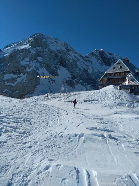
Protected by the wild surroundings of jakob aljaž, 93, konjsko sedlo - kredarica, gorje, 4281, eslovenia, the Triglavski dom na Kredarici refuge is your best ally at 2515 meters of elevation. Once you reach its coordinates (46.379, 13.849), you can enjoy a well-deserved mountain rest.

See more
See more
Usuario

Lucas Martinez

Premium user

Live weather: Triglavski dom na Kredarici

Before heading to Triglavski dom na Kredarici, check the weather: we currently have 1.1°C (feels like -2.4°C). With wind gusts reaching 18.4 km/h and a freezing level around 2940 meters, the daytime high will not exceed 7.9°C.
Temperature

1.1°C

Feels like: -2.4°C
Wind

7.2 km/h

Gusts: 18.4 km/h
Freezing level 0°

2940 m

Snow line
Sky & UV

UV 0

Clouds: 0%

Next 48 hours evolution

7-day forecast

04/06
7.9° 1.1°
0 mm 16.9 km/h UV máx: 7.35
05:14 20:51
05/06
4.1° 2.2°
22.5 mm 15.8 km/h UV máx: 0.5
05:14 20:52
06/06
9.1° 1.5°
0 mm 8.8 km/h UV máx: 6
05:13 20:53
07/06
12.2° 4.3°
2.1 mm 10.8 km/h UV máx: 6.85
05:13 20:54
08/06
11.4° 4.7°
0.6 mm 9.6 km/h UV máx: 5.55
05:12 20:54
09/06
12.3° 5.2°
3.6 mm 11.4 km/h UV máx: 6.5
05:12 20:55
10/06
6.8° 2.4°
5.4 mm 12.2 km/h UV máx: 3.6
05:12 20:55

Kredarica on a long climb

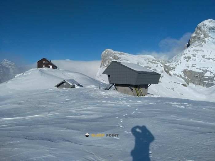
At this point, every detour counts. Triglavski dom na Kredarici , at 2,515 meters, it appears as a clear reference to guide and order the day in the high environment of the massif Triglav within the national park of the same name and in the middle of the Julians Alps. More than just a point on the map, it works as a step support in an area where the relief is already fully alpine and the weather can change quickly. Its position makes it particularly useful by channelling climbing or crossing routes such as Pot čez Prag, Tominškova pot or Pot čez Plemenice, all associated with access to the highest mountain in Slovenia and its high slopes.

Connections and margin of autonomy

For planning, it is appropriate to understand it as a place that can be used both to start a demanding approach and to link long routes, rather than as a comfortable basis for several days if the terrain is not well known. The proximity of marked and passing itineraries, along with altitude, reinforces its role as a reference mountain shelter in navigation. In contrast, the available data do not allow for fact equipment, interior status or continuous supply. As for water, the nearest registered source is about 1.7 km, a relevant distance on high ground; it is therefore prudent to leave with sufficient autonomy and to check before the route both the actual availability of water and the conditions of access. In this sector of the Triglav, using the shelter as an intermediate stage or as a point of passage depends above all on the length of the day, the weather forecast and the experience in high mountain terrain.

Hiking routes from the refuge

Local

Soška pot

↔ 25 km km
Local

Pot čez Prag

↔ Variable distance
Local

Tominškova pot

↔ Variable distance
Local

Pot čez Plemenice

↔ Variable distance
Local

Gorjanska pot

↔ Variable distance
Local

Grebenska pot

↔ Variable distance
Local

Slovenska pot

↔ Variable distance
1

Slovenska planinska pot

↔ Variable distance

Nearby water fountains

Fuente

1.73 Km
Lat: 0 Lon: 0

Velo Polje

2.38 Km
Lat: 0 Lon: 0

Korito pri Vodnikovem domu

2.74 Km
Lat: 0 Lon: 0

Fuente

3.36 Km
Lat: 0 Lon: 0

Fuente

4.31 Km
Lat: 0 Lon: 0

Fuente

4.54 Km
Lat: 0 Lon: 0

Fuente

4.65 Km
Lat: 0 Lon: 0

Fuente

4.66 Km
Lat: 0 Lon: 0
FAQ

Frequently asked questions

Pregunta frecuente
Is it necessary to carry a GPS to reach the Triglavski dom na Kredarici refuge?
It is always highly recommended to carry a GPS device, a route track, or a topographic map in the mountains. You can use the coordinates 46.379, 13.849 to locate this refuge precisely.
Pregunta frecuente
Are there other mountain refuges near Triglavski dom na Kredarici?
Yes, nearby you can find other options to spend the night or take shelter. El refugio más próximo es el Dom Valentina Staniča pod Triglavom, que se encuentra a aproximadamente 1.3 km de distancia.
Pregunta frecuente
At what exact altitude is the Triglavski dom na Kredarici refuge located?
The Triglavski dom na Kredarici refuge is located at an altitude of 2515 meters above sea level, in the natural surroundings of jakob aljaž, 93, konjsko sedlo - kredarica, gorje, 4281, eslovenia.
More areas

Other areas

Collaborative

Together we improve

image

Send your photos

You can upload photos of shelters and update their status so other users know if they can go there.

Get started
Get started
image

Rate the shelter

Leave your comments to rate the shelter’s condition. In the mountains, we look after each other.

Get started
Get started
image

Add new ones

Did we miss any? Publish the shelters you know so everyone can use them.

Get started
Get started
Download for free from the Apple App Store and Play Store.

Download the app and start looking for the shelter of your next adventure

Aplicación móvil para encontrar refugios de montaña donde dormir
Aplicación móvil para encontrar refugios de montaña donde dormir.
Mapa interactivo de refugios de montaña en los Pirineos dentro de la app
Mapa de refugios de montaña para senderismo y trekking en la app.
Pantalla con información de refugio de montaña con altitud capacidad y servicios
Pantalla con información de refugio de montaña con altitud capacidad y servicios.
Detalles de refugio de montaña con servicios y meteorología en aplicación móvil
Detalles de refugio de montaña con servicios y meteorología en aplicación móvil.
Aplicación para explorar refugios de montaña mediante mapa interactivo
Aplicación para explorar refugios de montaña mediante mapa interactivo.
Ficha completa de refugio de montaña con opiniones y servicios
Ficha completa de refugio de montaña con opiniones y servicios.
Información detallada de refugio en app para montañeros
Información detallada de refugio en app para montañeros.
Listado de refugios de montaña para senderismo y trekking
Listado de refugios de montaña para senderismo y trekking.
Explorar refugios de montaña desde una aplicación móvil
Explorar refugios de montaña desde una aplicación móvil.