Mountain refuge A PreZasavska koča nhodavcih

We have it listed in the app!


            Mountain refuge A PreZasavska koča nhodavcih in zasavska koča na prehodavcih, 89, pot mire marko debelakove, prehodavci, bovec, 5232, eslovenia
Five orange stars in a horizontal row representing a five-star rating.

A PreZasavska koča nhodavcih

Lat: 46.358xxx – Lon: 13.792xxx
📍 zasavska koča na prehodavcih, 89, pot mire marko debelakove, prehodavci, bovec, 5232, eslovenia
A PreZasavska koča nhodavcih

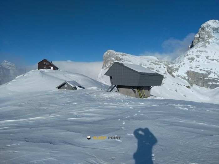
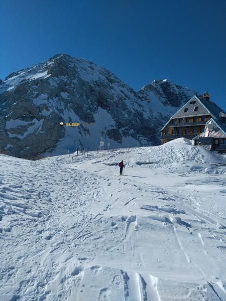
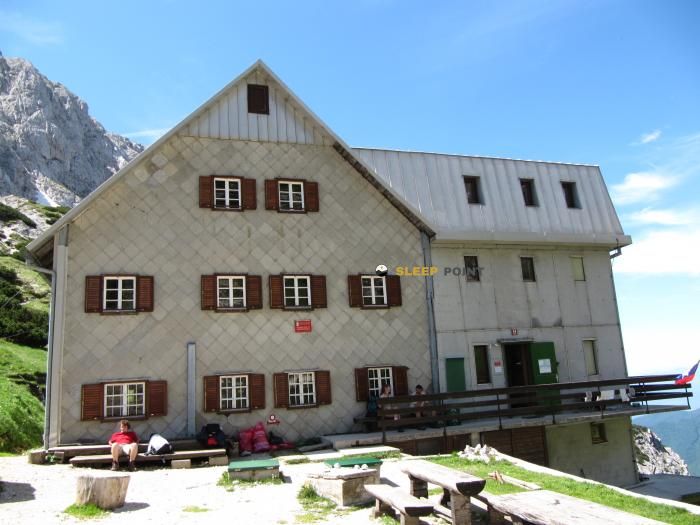
Located in the heart of zasavska koča na prehodavcih, 89, pot mire marko debelakove, prehodavci, bovec, 5232, eslovenia, the A PreZasavska koča nhodavcih refuge offers shelter at 2058 meters above sea level. Ideal for trekking and nature lovers, this mountain shelter (Lat: 46.358, Lon: 13.792) is the perfect starting point or resting place for local routes.

See more
See more
Usuario

Lucas Martinez

Premium user

Live weather: A PreZasavska koča nhodavcih

The current weather in A PreZasavska koča nhodavcih indicates a temperature of 3.6°C, although the 2.2 km/h wind makes it feel like 1.2°C. Watch out for gusts of 25.9 km/h. The snow altitude (freezing level 0°) is around 2830 m and today we will reach a high of 10.5°C.
Temperature

3.6°C

Feels like: 1.2°C
Wind

2.2 km/h

Gusts: 25.9 km/h
Freezing level 0°

2830 m

Snow line
Sky & UV

UV 0

Clouds: 0%

Next 48 hours evolution

7-day forecast

04/06
10.5° 3.1°
0 mm 14.5 km/h UV máx: 7.4
05:14 20:51
05/06
6.9° 5.1°
22.6 mm 12.5 km/h UV máx: 0.55
05:14 20:52
06/06
11.4° 4.3°
0 mm 10.9 km/h UV máx: 5.8
05:13 20:53
07/06
14.3° 6.9°
1.8 mm 9.6 km/h UV máx: 6.7
05:13 20:54
08/06
13.7° 7.4°
0.3 mm 8.2 km/h UV máx: 7.05
05:13 20:54
09/06
15.4° 8.6°
4.5 mm 10.8 km/h UV máx: 7
05:12 20:55
10/06
10.3°
4.8 mm 11.2 km/h UV máx: 5.1
05:12 20:56

Alpine step or base

A PreZasavska koča nhodavcih , at 2,058 meters, it fits better as a step shelter than as a simple isolated ascension point. Its position in the environment of Triglav and the valley of the Lagos de Triglav places it in a clearly alpine strip, above the forest and on land where the rocky relief, the hills and the open slopes make the day very much conditioned. From here it is well understood its usefulness to divide long routes within the Julian Alps : is close to tops as Kanjavec , very close, and also of major references such as Veliko Špičje or Triglav itself, already at a distance. In this context, it not only serves to raise a concrete rise, but also to channel and distribute effort on mountain itineraries where too long a stage can be complicated quickly if time changes.

What should be assessed

For those who trekking or high mountain in the Bovec area, the decision to pass through this shelter makes sense especially if you seek intermediate support on long routes, rather than a comfortable stop next to a simple access. For the nearby itineraries that appear in the sector, such as Soška pot or some classic Slovenian mountain roads, it should be assumed that the terrain can be variable and that orientation and meteorology have real weight in planning. Autonomy is also important: the registered sources are not next to the shelter, but several kilometres away, so it is not necessary to have immediate water without having checked it before. In such an exposed and high area, this combination of distance to water, a high mountain environment and possible link role between stages makes the shelter work mainly as logistical support within a journey, especially when it is interested in shortening a day or leaving room for changing conditions.

Hiking routes from the refuge

Local

Soška pot

↔ 25 km km
Local

Pot čez Prag

↔ Variable distance
Local

Tominškova pot

↔ Variable distance
Local

Pot čez Plemenice

↔ Variable distance
Local

Gorjanska pot

↔ Variable distance
Local

Grebenska pot

↔ Variable distance
Local

Kopiščarjeva pot

↔ Variable distance
Local

Slovenska pot

↔ Variable distance

Nearby peaks

Triglav

2864 m
Lat: 46.3783 Lon: 13.8366

Tosc

2273 m
Lat: 46.3567 Lon: 13.8684

Veliko Špičje

2398 m
Lat: 46.3439 Lon: 13.767

Kanjavec

2569 m
Lat: 46.3601 Lon: 13.8098

Križ

2410 m
Lat: 46.4101 Lon: 13.8112

Bovški Gamsovec

2392 m
Lat: 46.3982 Lon: 13.8127

Malo Špičje

2312 m
Lat: 46.3518 Lon: 13.7829

Goriški rob

2320 m
Lat: 46.3474 Lon: 13.7773

Nearby water fountains

Fuente

3.17 Km
Lat: 46.3474 Lon: 13.7773

Fuente

3.36 Km
Lat: 46.3474 Lon: 13.7773

Fuente

3.58 Km
Lat: 46.3474 Lon: 13.7773

Pipa na trgu v Trenti

3.99 Km
Lat: 46.3474 Lon: 13.7773

Fuente

4 Km
Lat: 46.3474 Lon: 13.7773

Fuente

4.24 Km
Lat: 46.3474 Lon: 13.7773

Fuente

4.46 Km
Lat: 46.3474 Lon: 13.7773

Fuente

4.52 Km
Lat: 46.3474 Lon: 13.7773
FAQ

Frequently asked questions

Pregunta frecuente
What are the GPS coordinates of the A PreZasavska koča nhodavcih refuge?
To locate the A PreZasavska koča nhodavcih refuge on your GPS or map, use the following coordinates: Latitude 46.358 and Longitude 13.792.
Pregunta frecuente
Is it necessary to carry a GPS to reach the A PreZasavska koča nhodavcih refuge?
It is always highly recommended to carry a GPS device, a route track, or a topographic map in the mountains. You can use the coordinates 46.358, 13.792 to locate this refuge precisely.
Pregunta frecuente
Are there other mountain refuges near A PreZasavska koča nhodavcih?
Yes, nearby you can find other options to spend the night or take shelter. El refugio más próximo es el Triglavski dom na Kredarici, que se encuentra a aproximadamente 4.9 km de distancia.
More areas

Other areas

Collaborative

Together we improve

image

Send your photos

You can upload photos of shelters and update their status so other users know if they can go there.

Get started
Get started
image

Rate the shelter

Leave your comments to rate the shelter’s condition. In the mountains, we look after each other.

Get started
Get started
image

Add new ones

Did we miss any? Publish the shelters you know so everyone can use them.

Get started
Get started
Download for free from the Apple App Store and Play Store.

Download the app and start looking for the shelter of your next adventure

Aplicación móvil para encontrar refugios de montaña donde dormir
Aplicación móvil para encontrar refugios de montaña donde dormir.
Mapa interactivo de refugios de montaña en los Pirineos dentro de la app
Mapa de refugios de montaña para senderismo y trekking en la app.
Pantalla con información de refugio de montaña con altitud capacidad y servicios
Pantalla con información de refugio de montaña con altitud capacidad y servicios.
Detalles de refugio de montaña con servicios y meteorología en aplicación móvil
Detalles de refugio de montaña con servicios y meteorología en aplicación móvil.
Aplicación para explorar refugios de montaña mediante mapa interactivo
Aplicación para explorar refugios de montaña mediante mapa interactivo.
Ficha completa de refugio de montaña con opiniones y servicios
Ficha completa de refugio de montaña con opiniones y servicios.
Información detallada de refugio en app para montañeros
Información detallada de refugio en app para montañeros.
Listado de refugios de montaña para senderismo y trekking
Listado de refugios de montaña para senderismo y trekking.
Explorar refugios de montaña desde una aplicación móvil
Explorar refugios de montaña desde una aplicación móvil.