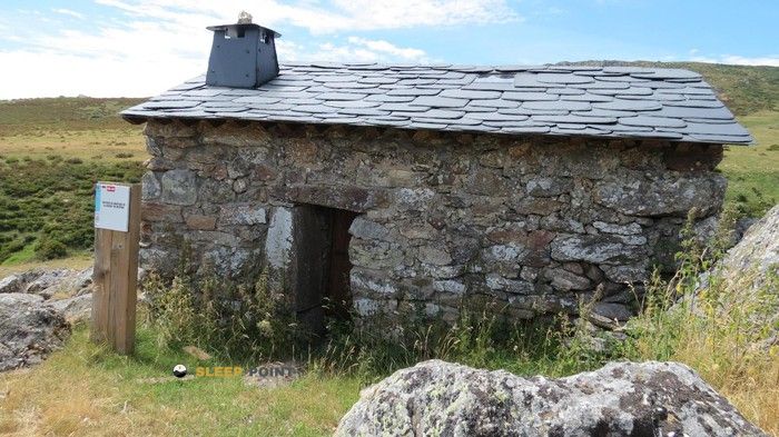
Mountain refuge Refugio de la Majada de Trefacio
We have it listed in the app!
We have it listed in the app!


Protected by the wild surroundings of refugio de la majada de trefacio, sendero laguna de los peces - peña trevinca gr 84, porto, zamora, castilla y león, españa, the Refugio de la Majada de Trefacio refuge is your best ally at 1585 meters of elevation. Once you reach its coordinates (42.209, -6.762), you can enjoy a well-deserved mountain rest.
10.5°C
Feels like: 6°C15.1 km/h
Gusts: 68 km/h4460 m
Snow lineUV 0
Clouds: 88% 0.1 mm
 20.4 km/h
 UV máx: 8.1
 06:52
06:52
 21:58
0 mm
13.7 km/h
UV máx: 7.85
06:51
21:59
0 mm
14 km/h
UV máx: 8.2
06:51
22:00
0 mm
12.3 km/h
UV máx: 7.8
06:51
22:00
0 mm
15.5 km/h
UV máx: 8.35
06:50
22:01
0 mm
8.2 km/h
UV máx: 7.95
06:50
22:01
0 mm
9.5 km/h
UV máx: 7.95
06:50
22:02
21:58
0 mm
13.7 km/h
UV máx: 7.85
06:51
21:59
0 mm
14 km/h
UV máx: 8.2
06:51
22:00
0 mm
12.3 km/h
UV máx: 7.8
06:51
22:00
0 mm
15.5 km/h
UV máx: 8.35
06:50
22:01
0 mm
8.2 km/h
UV máx: 7.95
06:50
22:01
0 mm
9.5 km/h
UV máx: 7.95
06:50
22:02
Crossing from the Laguna de los Fish to the highest summits of Sanabria means moving through a high mountain terrain where time management is critical. The paths that go to Pena Trevinca or they turn to the Senda of the Rota Dam mark the pace of a demanding day. In this transition environment between the valleys of Porto and the granite peaks, the mountain shelter becomes a reference for those who need to break the stage before facing the final levels towards the ceilings of the massif.
At 1585 meters of altitude, the Refuge of the Majada de Trefacio offers a strategic support point when the accumulated tiredness or a sudden change in visibility advise not to continue towards the Upper Bouza. Its location allows to assess the physical state before deciding whether to continue to the Laguna de las Yeguas circus or whether to go down to the Cañón del Tera, an area historically marked by water force in the Vega de Tera.
For the mountaineer in autonomy, having the Fountain of the Majada de Trefacio a few meters from the construction is a determining factor in the planning. This resource is vital if you plan to link with the Senda del Cañón del Río Forcadura or if you want to reach peaks like Pena Surbia o Peña Cabrita. The availability of water in the vicinity reinforces the utility of this sector as an operational basis for cross-roads that require several days of running through the saw.
The desirability of using this installation is often subject to weather and passing hours. In days of storm or closed fog, frequent phenomena in this sector, the shelter provides the necessary protection to expect favourable conditions before winning the ridge. It is a space that requires total self-sufficiency, designed for those seeking the isolation offered by the most remote and less transit areas of the natural park.
The surrounding landscape stands out by a relief of glacial origin where pedestres and canchals predominate. By integrating close to long-range routes such as GR 84 this point facilitates the connection between different valleys without the need to return to low levels. It works as a fundamental link to understand the orography of this area of Zamora and ensure a smooth progression through its mountain cords and ports.


📏 0.8 Km
⛰️ 1625 m

📏 0.8 Km
⛰️ 1606 m

📏 3.5 Km
⛰️ 1810 m

📏 3.8 Km
⛰️ 1534 m

📏 4.9 Km
⛰️ 1766 m

📏 5.2 Km
⛰️ 1830 m
📏 8 Km
⛰️ 1610 m

📏 8.6 Km
⛰️ 1602 m
Download the app and start looking for the shelter of your next adventure


Find a place to sleep before night falls.


