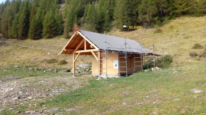
Mountain refuge Refuge des Fontainiers
We have it listed in the app!
We have it listed in the app!


If you are planning a route through refuge des fontainiers, route forestière des fontaniers, folampelle, embrun, gap, altos alpes, provenza-alpes-costa azul, francia metropolitana, 05200, francia, the Refuge des Fontainiers refuge is a must-stop. Located at 1700 m above sea level, it offers hikers and climbers a safe place to regain strength. Save its coordinates (44.594, 6.469) in your GPS to stay on course during your journey.
9.4°C
Feels like: 5.8°C8.3 km/h
Gusts: 18 km/h4040 m
Snow lineUV 0
Clouds: 98% 30.6 mm
 13.4 km/h
 UV máx: 6.7
 05:50
05:50
 21:14
0.2 mm
12.2 km/h
UV máx: 7.65
05:50
21:15
0 mm
15.2 km/h
UV máx: 7.95
05:49
21:15
0 mm
13.7 km/h
UV máx: 7.9
05:49
21:16
0.15 mm
15.5 km/h
UV máx: 7.6
05:49
21:17
0 mm
13.7 km/h
UV máx: 6.75
05:48
21:17
0 mm
14.3 km/h
UV máx: 7.65
05:48
21:18
21:14
0.2 mm
12.2 km/h
UV máx: 7.65
05:50
21:15
0 mm
15.2 km/h
UV máx: 7.95
05:49
21:15
0 mm
13.7 km/h
UV máx: 7.9
05:49
21:16
0.15 mm
15.5 km/h
UV máx: 7.6
05:49
21:17
0 mm
13.7 km/h
UV máx: 6.75
05:48
21:17
0 mm
14.3 km/h
UV máx: 7.65
05:48
21:18
The approach to Refuge des Fontainiers It fits better in a day thought with margin than in an improvised exit. At 1,700 metres, in the surroundings of Embrun and the Altos Alpes, it works mainly as a useful mountain shelter to cut a retreat, break a journey or have a basic support point before returning to lower heights. The presence of a source at about 100 metres is a favourable fact, but in mountain it is appropriate not to make sure its availability without checking it before.
The relief around it quickly ascends to the tops as Tête de Chante-Perdrix , Tête de l'Hivernet or Tête de Soloil-Bœuf , all above 2,700 meters and relatively close. This contrast between an average level of shelter and a clearly alpine horizon helps to understand its role: not so much a destination in itself as an intermediate piece in mountain terrain, where time can change and the orientation of the day matters. The environment is that of the mountainous side that dominates the Embrun sector and the environment of Serre-Ponçon , with itineraries that combine forest slopes, balconies and links to higher areas.
It also makes sense within longer routes. In this area, traces are passed known as the Balcons de Serre-Ponçon and GR 50 , Tour du Parc National des Écrins, so that the shelter can be read as logistical support in a broader route planning. Since there is no complete data on equipment or interior state, it is reasonable to raise it with autonomy, especially if it is used as an alternative for withdrawal, passing night or reorganisation point to dubious weather.


📏 0.4 Km
⛰️ 1830 m

📏 1.1 Km
⛰️ 1875 m

📏 1.8 Km
⛰️ 2262 m

📏 4.9 Km
⛰️ 2030 m

📏 6.1 Km
⛰️ 1900 m

📏 8.4 Km
⛰️ 2080 m

📏 8.7 Km
⛰️ 2120 m

📏 9.1 Km
⛰️ 1979 m
Download the app and start looking for the shelter of your next adventure


Find a place to sleep before night falls.


