Mountain refuge Refuge de Pré Clos

We have it listed in the app!


            Mountain refuge Refuge de Pré Clos in refuge de pré clos, route forestière des fontaniers, embrun, gap, altos alpes, provenza-alpes-costa azul, francia metropolitana, 05200, francia
Five orange stars in a horizontal row representing a five-star rating.

Refuge de Pré Clos

Lat: 44.594xxx – Lon: 6.464xxx
📍 refuge de pré clos, route forestière des fontaniers, embrun, gap, altos alpes, provenza-alpes-costa azul, francia metropolitana, 05200, francia
Refuge de Pré Clos

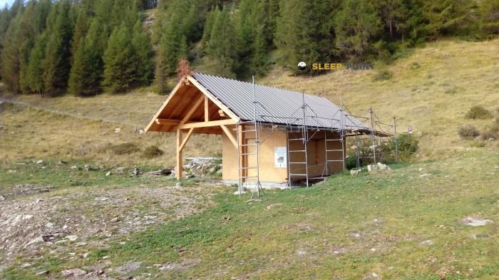
If you are planning a route through refuge de pré clos, route forestière des fontaniers, embrun, gap, altos alpes, provenza-alpes-costa azul, francia metropolitana, 05200, francia, the Refuge de Pré Clos refuge is a must-stop. Located at 1830 m above sea level, it offers hikers and climbers a safe place to regain strength. Save its coordinates (44.594, 6.464) in your GPS to stay on course during your journey.

See more
See more
Usuario

Lucas Martinez

Premium user

Live weather: Refuge de Pré Clos

Live weather from Refuge de Pré Clos shows 8.7°C and skies with 0% cloudiness. Wind is blowing at 1.8 km/h, lowering the feels-like temperature to 7.1°C. For high-altitude trips, the freezing level is at 4170 m and the maximum temperature will be 13.9°C.
Temperature

8.7°C

Feels like: 7.1°C
Wind

1.8 km/h

Gusts: 3.6 km/h
Freezing level 0°

4170 m

Snow line
Sky & UV

UV 0

Clouds: 0%

Next 48 hours evolution

7-day forecast

03/06
13.9° 3.4°
0 mm 12.5 km/h UV máx: 7.85
05:51 21:13
04/06
13.8° 5.1°
28.9 mm 13.9 km/h UV máx: 7.6
05:50 21:14
05/06
13° 2.6°
0 mm 13.6 km/h UV máx: 7.65
05:50 21:15
06/06
15.5° 6.2°
0 mm 17.2 km/h UV máx: 7.75
05:49 21:15
07/06
17.6° 7.4°
0 mm 13.9 km/h UV máx: 7.9
05:49 21:16
08/06
18.3° 9.8°
0 mm 12.7 km/h UV máx: 7.8
05:49 21:17
09/06
17.1° 9.2°
0 mm 13.7 km/h UV máx: 7.25
05:48 21:17

On this slope over Embrun , the coat fits well as a cut-off point when the schedule is extended, the meteor is complicated or the effort is sought to be shared on a ground of medium and high mountain. At 1,830 metres, the Refuge de Pré Clos It is in a transition strip where the forest leaves way to more open reliefs, with a reading of the terrain marked by loins, clear and rounded summits that rise above the sector. The reference of the route forestère des Fontaniers helps to place it on an accessible side from the Embrun environment, but already high enough to demand planning, especially if it is reached with backpack or with changing conditions. In this context, it is not appropriate to interpret it as a simple walk-in shelter: the altitude, the exposure to time and the mountain character of the access weigh more than the proximity relative to the valley.

Their practical interest is in supporting tours linking balconies on Serre-Ponçon with longer routes of the Ecrins including the GR 50 on the big lap of the park. It can also function as a basis for moving to nearby reliefs such as the Tête de Chante-Perdrix or the Tête de l'Hivernet, not as much as a platform for technical ascension alone, but as a point from which to gain height with margin if the day starts soon. There is a source pointed at about 400 meters, useful data but it does not eliminate the need for autonomy, because in mountain the actual availability of water may vary. To be well oriented it is appropriate to carry map or track and read the relief with attention: in this area local itineraries, crossing links and forest routes can be crossed, and that changes the perception of distance when fog, tiredness or storm enter.

Hiking routes from the refuge

Local

Balcons de Serre-Ponçon

↔ Variable distance
GR 50

Tour du Parc National des Écrins

↔ 369 km
Local

Via Domitia, Montgenèvre - Eygalières

↔ Variable distance
Local

Belvédère Roche Rousse

↔ 3.4 km
Local

Boucle de la Cabane de l'Aiguille

↔ 5.4 km
Local

Boucle de la Mûre

↔ 3.3 km
Local

Boucle de Plat Aiguille

↔ 12 km
Local

Boucle de Saint-Alban

↔ 9.1 km

Nearby peaks

Pointe de Serre

2909 m
Lat: 44.619 Lon: 6.3986

Tête de Chante-Perdrix

2720 m
Lat: 44.6024 Lon: 6.436

Tête de Soleil-Bœuf

2810 m
Lat: 44.6252 Lon: 6.4574

Tête de l'Hivernet

2823 m
Lat: 44.6197 Lon: 6.4528

Pic de Pied Brun

2690 m
Lat: 44.6172 Lon: 6.4252

Tête de la Cabane

2545 m
Lat: 44.6311 Lon: 6.4315

Tête du Tissap

2688 m
Lat: 44.623 Lon: 6.4307

L'Arpion

2671 m
Lat: 44.5979 Lon: 6.4361

Nearby water fountains

Fuente

411 m
Lat: 44.5979 Lon: 6.4361

chapelle Saint Jean Baptiste

2.32 Km
Lat: 44.5979 Lon: 6.4361

Fontaine-Lavoir

2.94 Km
Lat: 44.5979 Lon: 6.4361

Fuente

4.04 Km
Lat: 44.5979 Lon: 6.4361

Fuente

4.12 Km
Lat: 44.5979 Lon: 6.4361

A la mémoire des morts pour la défense de la patrie 1870-1871

4.14 Km
Lat: 44.5979 Lon: 6.4361

Fuente

4.19 Km
Lat: 44.5979 Lon: 6.4361

Fuente

4.25 Km
Lat: 44.5979 Lon: 6.4361
FAQ

Frequently asked questions

Pregunta frecuente
Are there other mountain refuges near Refuge de Pré Clos?
Yes, nearby you can find other options to spend the night or take shelter. El refugio más próximo es el Refuge des Fontainiers, que se encuentra a aproximadamente 0.4 km de distancia.
Pregunta frecuente
At what exact altitude is the Refuge de Pré Clos refuge located?
The Refuge de Pré Clos refuge is located at an altitude of 1830 meters above sea level, in the natural surroundings of refuge de pré clos, route forestière des fontaniers, embrun, gap, altos alpes, provenza-alpes-costa azul, francia metropolitana, 05200, francia.
Pregunta frecuente
What are the GPS coordinates of the Refuge de Pré Clos refuge?
To locate the Refuge de Pré Clos refuge on your GPS or map, use the following coordinates: Latitude 44.594 and Longitude 6.464.
More areas

Other areas

Collaborative

Together we improve

image

Send your photos

You can upload photos of shelters and update their status so other users know if they can go there.

Get started
Get started
image

Rate the shelter

Leave your comments to rate the shelter’s condition. In the mountains, we look after each other.

Get started
Get started
image

Add new ones

Did we miss any? Publish the shelters you know so everyone can use them.

Get started
Get started
Download for free from the Apple App Store and Play Store.

Download the app and start looking for the shelter of your next adventure

Aplicación móvil para encontrar refugios de montaña donde dormir
Aplicación móvil para encontrar refugios de montaña donde dormir.
Mapa interactivo de refugios de montaña en los Pirineos dentro de la app
Mapa de refugios de montaña para senderismo y trekking en la app.
Pantalla con información de refugio de montaña con altitud capacidad y servicios
Pantalla con información de refugio de montaña con altitud capacidad y servicios.
Detalles de refugio de montaña con servicios y meteorología en aplicación móvil
Detalles de refugio de montaña con servicios y meteorología en aplicación móvil.
Aplicación para explorar refugios de montaña mediante mapa interactivo
Aplicación para explorar refugios de montaña mediante mapa interactivo.
Ficha completa de refugio de montaña con opiniones y servicios
Ficha completa de refugio de montaña con opiniones y servicios.
Información detallada de refugio en app para montañeros
Información detallada de refugio en app para montañeros.
Listado de refugios de montaña para senderismo y trekking
Listado de refugios de montaña para senderismo y trekking.
Explorar refugios de montaña desde una aplicación móvil
Explorar refugios de montaña desde una aplicación móvil.