Mountain refuge Gîte d’étape municipal du Pont de Montvert

We have it listed in the app!


            Mountain refuge Gîte d’étape municipal du Pont de Montvert in gîte d'étape municipal du pont-de-montvert, les chemins du champ du temple, le chambon, le pont-de-montvert, pont de montvert - sud mont lozère, florac, lozère, occitania, francia metropolitana, 48220, francia
Five orange stars in a horizontal row representing a five-star rating.

Gîte d’étape municipal du Pont de Montvert

Lat: 44.366xxx – Lon: 3.746xxx
📍 gîte d'étape municipal du pont-de-montvert, les chemins du champ du temple, le chambon, le pont-de-montvert, pont de montvert - sud mont lozère, florac, lozère, occitania, francia metropolitana, 48220, francia
Gîte d’étape municipal du Pont de Montvert

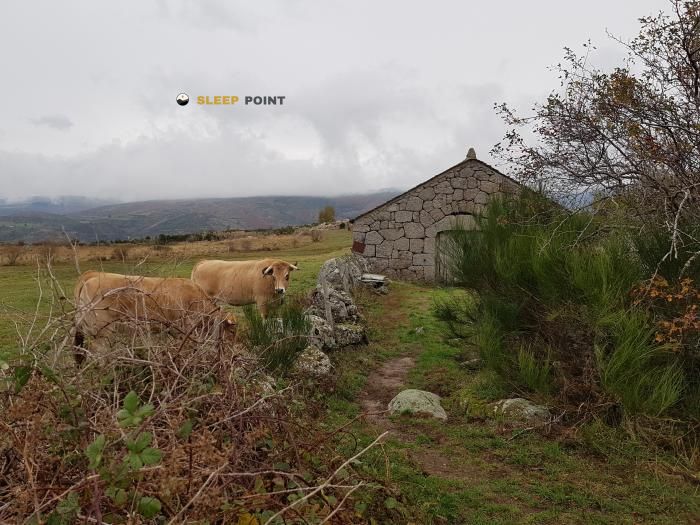
The Gîte d’étape municipal du Pont de Montvert refuge acts as a base camp for the summits and routes of gîte d'étape municipal du pont-de-montvert, les chemins du champ du temple, le chambon, le pont-de-montvert, pont de montvert - sud mont lozère, florac, lozère, occitania, francia metropolitana, 48220, francia. At 920 meters of elevation, its coordinates (44.366, 3.746) represent safety after a long day of effort.

See more
See more
Usuario

Lucas Martinez

Premium user

Live weather: Gîte d’étape municipal du Pont de Montvert

Live weather from Gîte d’étape municipal du Pont de Montvert shows 11°C and skies with 100% cloudiness. Wind is blowing at 7.1 km/h, lowering the feels-like temperature to 9.7°C. For high-altitude trips, the freezing level is at 4320 m and the maximum temperature will be 18.2°C.
Temperature

11°C

Feels like: 9.7°C
Wind

7.1 km/h

Gusts: 16.9 km/h
Freezing level 0°

4320 m

Snow line
Sky & UV

UV 0

Clouds: 100%

Next 48 hours evolution

7-day forecast

03/06
18.2° 9.3°
0 mm 22.9 km/h UV máx: 7.2
06:02 21:23
04/06
14.3° 9.9°
10.3 mm 22.2 km/h UV máx: 3.05
06:02 21:24
05/06
16.1° 6.4°
0 mm 14.8 km/h UV máx: 7
06:02 21:25
06/06
19.7°
0 mm 19.6 km/h UV máx: 7.25
06:01 21:25
07/06
23.5° 9.6°
0 mm 8.3 km/h UV máx: 7.05
06:01 21:26
08/06
22.8° 12.4°
0.3 mm 15.7 km/h UV máx: 7.3
06:01 21:27
09/06
20.5° 13.3°
0.6 mm 17.8 km/h UV máx: 7.1
06:00 21:27

In the field of Pont de Montvert - Sud Mont Lozère , at 920 meters, this stage accommodation is in a useful position to read well the changes in direction of the land before gaining height towards the loops and reliefs that close the valley. It is not in a high-mountain pirenaic environment, but it is in an area where progression changes rapidly between the bottom of the valley, forest slopes and more open cords, something relevant when long routes are linked or a simple retreat is sought to the inhabited core.

Its main interest is in the connection with wide-ranging paths. References as well known as the GR 70 Chemin de Stevenson , in addition to GR 7 and GR 72 , in addition to the local tracks such as the Chemin de Malevrère or the Sentier de Mas Camargues. This combination makes it a practical point to divide days, correct course between neighbouring valleys or leave a journey without being isolated in high heights.

The orientation of the terrain is also understood by nearby elevations. To the near environment there are references such as Roc de la Fenêtre , less than 3 km, and beyond, you relive like Signal du Bougès or Le Chaumadou, which help to place the transition between the Lozère mountains and the itineraries that go back to more open areas. For those who advance on foot, this means paying attention to the detours and the reading of the map when the itinerary leaves the main valley.

In the key to autonomy, water is one of the most favourable points: there are several very close sources and a point identified as drinking water at about 300 meters. However, in the mountains it is appropriate to check their actual availability before they are dependent on them. As no internal equipment or services are detailed here, planning should be made with sufficient scope, especially if used as support within a longer journey.

Hiking routes from the refuge

Local

Chemin de Malevrère

↔ Variable distance
GR 70

Chemin de Stevenson - Part 6

↔ Variable distance
Local

Sentier de Mas Camargues

↔ 3 km
GR 7

Des Vosges aux Pyrénées 03, La Vaseraie - Signal du Ventalon

↔ 586 km
GR 7

Des Vosges aux Pyrénées 04, Signal du Ventalon - Prat Peyrot

↔ Variable distance
GR 72

Du Col du Bez à Barre-des-Cévennes (02)

↔ Variable distance
GR 72

Du Col du Bez à Barre-des-Cévennes (03)

↔ Variable distance
Local

Le Pont du Tarn

↔ 14.8 km

Nearby peaks

Signal du Bougès

1421 m
Lat: 44.3174 Lon: 3.726

Roc Panteloune

Altitude not available
Lat: 44.4005 Lon: 3.7607

Le Chaumadou

1395 m
Lat: 44.3675 Lon: 3.805

Roc de la Fenêtre

1422 m
Lat: 44.3805 Lon: 3.7759

Nearby water fountains

Fuente

174 m
Lat: 44.3805 Lon: 3.7759

Fuente

228 m
Lat: 44.3805 Lon: 3.7759

Fuente

268 m
Lat: 44.3805 Lon: 3.7759

Fuente

301 m
Lat: 44.3805 Lon: 3.7759

Eau potable

313 m
Lat: 44.3805 Lon: 3.7759

Fuente

568 m
Lat: 44.3805 Lon: 3.7759

Fuente

2.23 Km
Lat: 44.3805 Lon: 3.7759

Fuente

4.11 Km
Lat: 44.3805 Lon: 3.7759
FAQ

Frequently asked questions

Pregunta frecuente
At what exact altitude is the Gîte d’étape municipal du Pont de Montvert refuge located?
The Gîte d’étape municipal du Pont de Montvert refuge is located at an altitude of 920 meters above sea level, in the natural surroundings of gîte d'étape municipal du pont-de-montvert, les chemins du champ du temple, le chambon, le pont-de-montvert, pont de montvert - sud mont lozère, florac, lozère, occitania, francia metropolitana, 48220, francia.
Pregunta frecuente
What are the GPS coordinates of the Gîte d’étape municipal du Pont de Montvert refuge?
To locate the Gîte d’étape municipal du Pont de Montvert refuge on your GPS or map, use the following coordinates: Latitude 44.366 and Longitude 3.746.
Pregunta frecuente
Is it necessary to carry a GPS to reach the Gîte d’étape municipal du Pont de Montvert refuge?
It is always highly recommended to carry a GPS device, a route track, or a topographic map in the mountains. You can use the coordinates 44.366, 3.746 to locate this refuge precisely.
More areas

Other areas

Collaborative

Together we improve

image

Send your photos

You can upload photos of shelters and update their status so other users know if they can go there.

Get started
Get started
image

Rate the shelter

Leave your comments to rate the shelter’s condition. In the mountains, we look after each other.

Get started
Get started
image

Add new ones

Did we miss any? Publish the shelters you know so everyone can use them.

Get started
Get started
Download for free from the Apple App Store and Play Store.

Download the app and start looking for the shelter of your next adventure

Aplicación móvil para encontrar refugios de montaña donde dormir
Aplicación móvil para encontrar refugios de montaña donde dormir.
Mapa interactivo de refugios de montaña en los Pirineos dentro de la app
Mapa de refugios de montaña para senderismo y trekking en la app.
Pantalla con información de refugio de montaña con altitud capacidad y servicios
Pantalla con información de refugio de montaña con altitud capacidad y servicios.
Detalles de refugio de montaña con servicios y meteorología en aplicación móvil
Detalles de refugio de montaña con servicios y meteorología en aplicación móvil.
Aplicación para explorar refugios de montaña mediante mapa interactivo
Aplicación para explorar refugios de montaña mediante mapa interactivo.
Ficha completa de refugio de montaña con opiniones y servicios
Ficha completa de refugio de montaña con opiniones y servicios.
Información detallada de refugio en app para montañeros
Información detallada de refugio en app para montañeros.
Listado de refugios de montaña para senderismo y trekking
Listado de refugios de montaña para senderismo y trekking.
Explorar refugios de montaña desde una aplicación móvil
Explorar refugios de montaña desde una aplicación móvil.