Mountain refuge Cresta-Biwak SAC
We have it listed in the app!
We have it listed in the app!
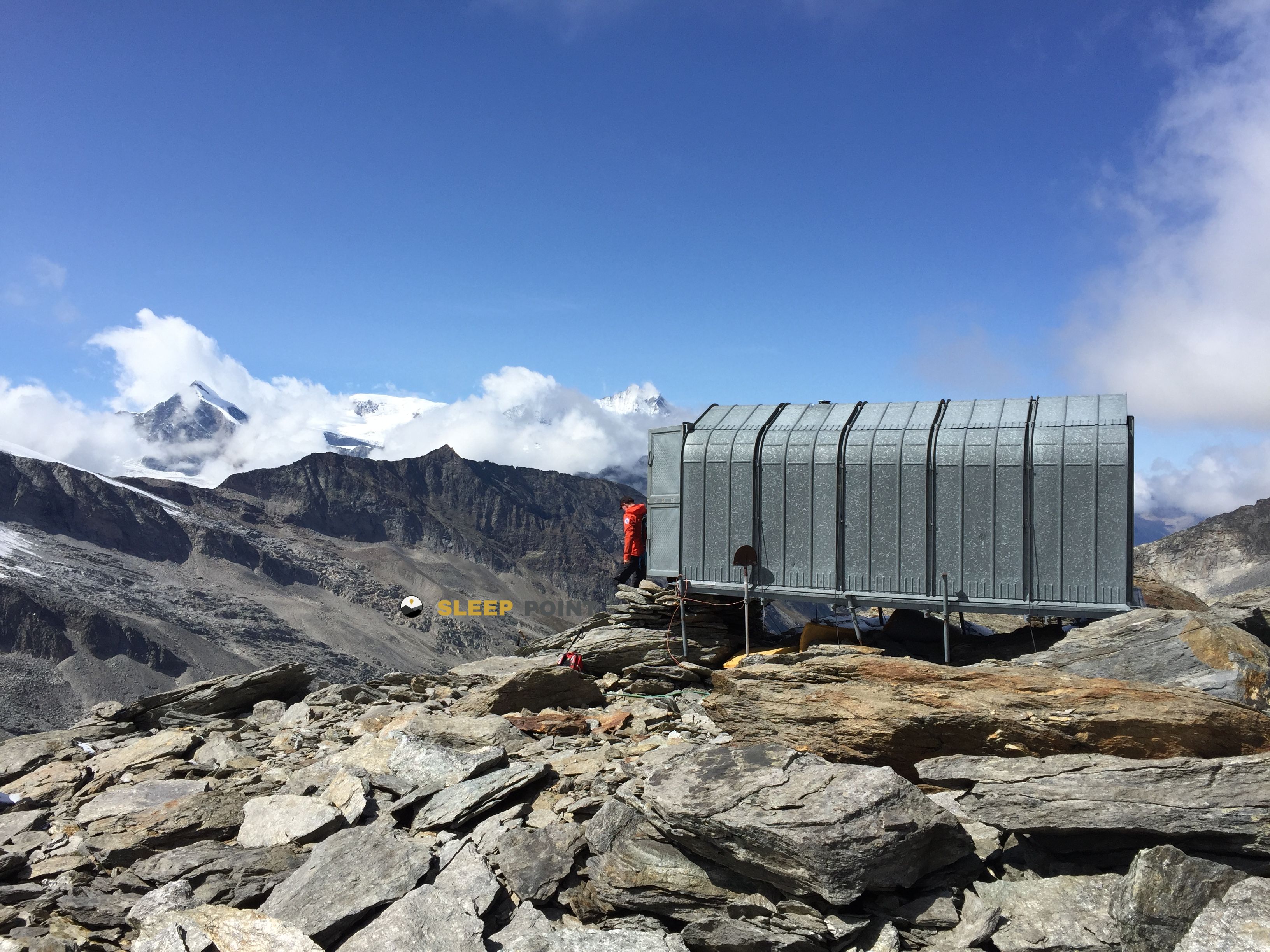

Conquering the trails of cresta-biwak, antronapass - heitbodme, saas-almagell, visp, vallés, 3905, suiza is easier with the Cresta-Biwak SAC refuge. Located at 3032 m (coordinates 46.045, 8.03), it is the ideal shelter against harsh mountain weather.
-0.4°C
Feels like: -4.3°C7.9 km/h
Gusts: 19.8 km/h3730 m
Snow lineUV 1.1
Clouds: 91% 12 mm
12 mm
 25.2 km/h
 UV máx: 3.75
 05:38
05:38
 21:13
1.4 mm
28.2 km/h
UV máx: 7.6
05:38
21:14
0.2 mm
13.5 km/h
UV máx: 4.95
05:38
21:15
0 mm
8.2 km/h
UV máx: 7.85
05:37
21:15
0 mm
13 km/h
UV máx: 8.1
05:37
21:16
7.2 mm
11.6 km/h
UV máx: 5.8
05:37
21:17
0 mm
13 km/h
UV máx: 5.3
05:36
21:17
21:13
1.4 mm
28.2 km/h
UV máx: 7.6
05:38
21:14
0.2 mm
13.5 km/h
UV máx: 4.95
05:38
21:15
0 mm
8.2 km/h
UV máx: 7.85
05:37
21:15
0 mm
13 km/h
UV máx: 8.1
05:37
21:16
7.2 mm
11.6 km/h
UV máx: 5.8
05:37
21:17
0 mm
13 km/h
UV máx: 5.3
05:36
21:17
More than just a high coat, this vivac fits mainly as an intermediate stop in long days. At 3,032 meters, in the environment of Saas- Almagell and very close to the line of passage between Switzerland and Italy, its role makes sense when it is sought to fail demanding tours or gain margin before a hill, a journey or a nearby ascension. The height already places the whole in a fully alpine environment. Open ground. Changing meteorology. And access that should be measured well according to the intended load and route.
The area connects with continuity routes, including the Simplon Futschhorn Trekking , the historical axis of Monte Moro and also stage 6 of the Tour Monte Rosa but it will not always compensate to deviate if you leave very just hours or forces. Its usefulness appears especially when you want to share the effort between two days, link basins or prepare an early exit on high ground. Around the shelter are summits such as Stelihorn , Augstkummenhorn , Spechhorn / Pizzo di Antigine or Pizzo Cingino Sud they strengthen their basic character to move through crest, hills and slopes of height rather than as an isolated destination.
In planning we should think about autonomy. The nearest source is almost 2 km away, so water should not be taken for granted when it comes. No specific equipment, capacity or services should be available without prior confirmation. By location and altitude, it is reasonable to predict rapid changes in time, low temperatures even out of season and a mountain orientation that can be complicated with fog or residual snow. In this type of location, the key decision is not only to arrive, but to decide whether the vivac really fits the logic of the stage.


📏 6.4 Km
⛰️ 2061 m

📏 6.7 Km
⛰️ 2782 m

📏 7.2 Km
⛰️ 2196 m

📏 7.2 Km
⛰️ 2894 m

📏 7.5 Km
⛰️ 3030 m

📏 10.7 Km
⛰️ 3562 m

📏 10.9 Km
⛰️ 3098 m

📏 11.1 Km
⛰️ 3029 m
Download the app and start looking for the shelter of your next adventure


Find a place to sleep before night falls.


