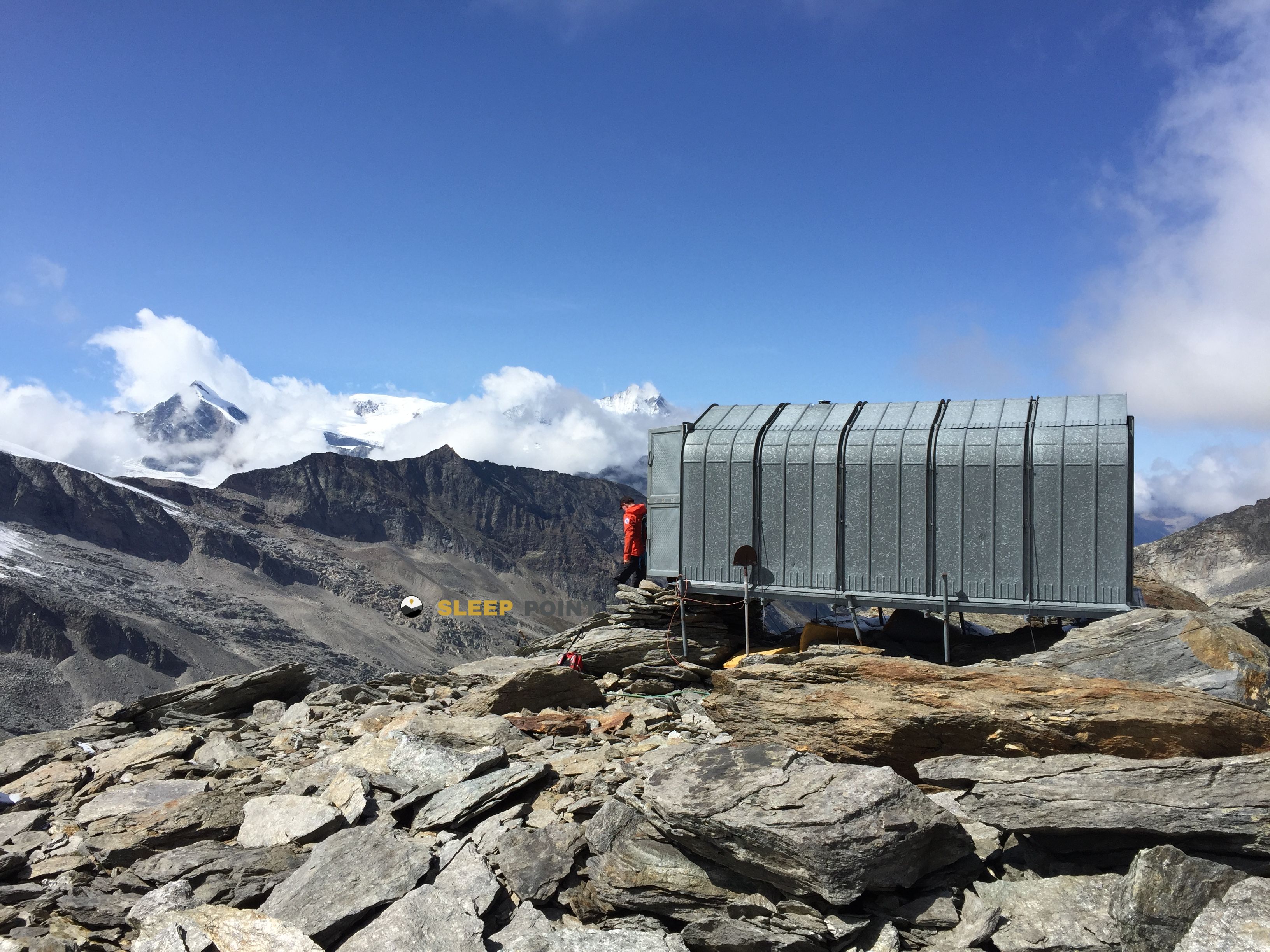
Mountain refuge Almagelleralp
We have it listed in the app!
We have it listed in the app!


The Almagelleralp refuge acts as a base camp for the summits and routes of almagelleralp, almagelleralp - sonnigpass, saas-almagell, visp, vallés, 3905, suiza. At 2196 meters of elevation, its coordinates (46.101, 7.985) represent safety after a long day of effort.
7.2°C
Feels like: 3.7°C4.5 km/h
Gusts: 8.3 km/h3870 m
Snow lineUV 0
Clouds: 85% 6.4 mm
 29.3 km/h
 UV máx: 3.75
 05:38
05:38
 21:14
0.9 mm
17.4 km/h
UV máx: 7.6
05:38
21:14
0.5 mm
13.5 km/h
UV máx: 4.95
05:38
21:15
0.3 mm
7.5 km/h
UV máx: 7.85
05:37
21:16
8.25 mm
9.7 km/h
UV máx: 8.1
05:37
21:17
0.3 mm
15.5 km/h
UV máx: 5.8
05:37
21:17
0 mm
15.6 km/h
UV máx: 5.3
05:36
21:18
21:14
0.9 mm
17.4 km/h
UV máx: 7.6
05:38
21:14
0.5 mm
13.5 km/h
UV máx: 4.95
05:38
21:15
0.3 mm
7.5 km/h
UV máx: 7.85
05:37
21:16
8.25 mm
9.7 km/h
UV máx: 8.1
05:37
21:17
0.3 mm
15.5 km/h
UV máx: 5.8
05:37
21:17
0 mm
15.6 km/h
UV máx: 5.3
05:36
21:18
We should go out with water. In Almagelleralp , on Saas-Almagell and at 2,196 meters in the Valais, the registered sources do not appear attached to the shelter, so the logistics weighs almost as much as the orientation. Its location fits better in a day of passage than in an improvised stop: it is within the scope of trails of the valley and close to longer routes of link, where a free shelter can serve both to fail stages and to withdraw from the most exposed terrain if the weather changes.
The surroundings of Saas- Almagell well marks that mountain transition that is seen in many alpine traverses: exit from the bottom of the inhabited valley, progression by hillsides and pastures of height, and higher an increasingly mineral landscape towards hills, pedestas and crests. This reading of the ground is reinforced by the proximity of summits such as Weisslies the border Pizzo d'Andolla and nearby reliefs such as Dri Horlini, which place the shelter in a clearly alpine sector of the Penins Alps, next to the Italian border.
It also makes sense for its relationship to several-day tours. In this area proposals such as the Swiss Tour Monte Rosa , Simplon Futschhorn Trekking , the Vie Storiche Monte Moro Saas Almagell or a stage of the Monte Rosa Tour, so that the shelter can function as intermediate support, reorganisation point or escape alternative within a journey. Access and real utility will depend on the chosen itinerary, but the context invites you to think of mountains with continuity, changes of land and the need for sufficient autonomy, especially if you are expected to stay overnight or a long day between valleys and steps of height.


Download the app and start looking for the shelter of your next adventure


Find a place to sleep before night falls.