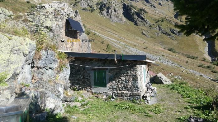
Mountain refuge Cabane des Lacs Robert
We have it listed in the app!
We have it listed in the app!


Conquering the trails of cabane des lacs roberts, passerelle himalayenne de la croix de chamrousse, chamrousse, grenoble, isère, auvergne-rhône-alpes, francia metropolitana, 38410, francia is easier with the Cabane des Lacs Robert refuge. Located at 2001 m (coordinates 45.131, 5.918), it is the ideal shelter against harsh mountain weather.
8.6°C
Feels like: 5.6°C4.6 km/h
Gusts: 20.9 km/h3980 m
Snow lineUV 0
Clouds: 100% 36.9 mm
 19.8 km/h
 UV máx: 4.7
 05:50
05:50
 21:18
0.3 mm
13.6 km/h
UV máx: 5.5
05:50
21:19
0 mm
9 km/h
UV máx: 7.85
05:50
21:20
0 mm
7.1 km/h
UV máx: 7.8
05:49
21:20
3 mm
7.4 km/h
UV máx: 6.45
05:49
21:21
1.2 mm
12.5 km/h
UV máx: 3
05:49
21:22
0 mm
8.4 km/h
UV máx: 7.55
05:48
21:22
21:18
0.3 mm
13.6 km/h
UV máx: 5.5
05:50
21:19
0 mm
9 km/h
UV máx: 7.85
05:50
21:20
0 mm
7.1 km/h
UV máx: 7.8
05:49
21:20
3 mm
7.4 km/h
UV máx: 6.45
05:49
21:21
1.2 mm
12.5 km/h
UV máx: 3
05:49
21:22
0 mm
8.4 km/h
UV máx: 7.55
05:48
21:22
Cabane des Lacs Robert It works best if it is understood in two ways: as a support to move through the high sector of Chamrouse and as a guard in an area where the terrain changes quickly. About 2001 meters away, next to the surroundings of the Lacs Robert and close to the Himalayenne passerelle of the Croix de Chamrouse, it is left in a strip where the mountain leaves behind the forest and enters into a more mineral landscape, with blocks, open slopes and steps that connect hills and loins.
Reading the map, its position is useful for linking local routes as the itinerary of Lacs Robert or the connection to Col des Lessines - Les Vannes, in addition to serving as a reference on longer routes that rise from low levels of Chamrouse. It is not necessary to consider it only as the end of the excursion: it can also fit as an intermediate or withdrawal point if the weather is complicated in the upper part. In this environment, the transition between comfortable path, stony terrain and areas more exposed to the wind can be very marked in a short distance.
The cabane is also close to reliefs that reinforce this moderate alpine character, such as Grand Eulier o Grand Van, nearby summits that help understand the arrangement of the cordal on which much of the network of itineraries moves. From there, the orientation depends very much on a good distinction between the side changes and not being trusted by the proximity of the station and its accesses: in fog, residual snow or storm, a simple stretch can no longer be quickly.
The day should be considered with autonomy. The registered sources are quite a distance, about 3 km or more, so it is not wise to have immediate water in the shelter environment. It is also not appropriate to base the exit on equipment or services. In an area as busy in summer as it is exposed outside stable conditions, this free shelter fits mainly as a mountain resource: useful for reorganizing the route, dividing a day or having an escape point, but not as an element on which to download all the logistics.


📏 2.1 Km
⛰️ 1510 m
📏 2.2 Km
⛰️ 1790 m

📏 3.1 Km
⛰️ 1265 m

📏 3.2 Km
⛰️ 1370 m

📏 3.7 Km
⛰️ 1465 m

📏 3.9 Km
⛰️ 2105 m

📏 4 Km
⛰️ 1210 m

📏 4.2 Km
⛰️ 1430 m
Download the app and start looking for the shelter of your next adventure


Find a place to sleep before night falls.


