Mountain refuge Cabane de la Forge

We have it listed in the app!


            Mountain refuge Cabane de la Forge in puilaurens, limoux, aude, occitania, francia metropolitana, francia
Five orange stars in a horizontal row representing a five-star rating.

Cabane de la Forge

Lat: 42.831xxx – Lon: 2.297xxx
📍 puilaurens, limoux, aude, occitania, francia metropolitana, francia
Cabane de la Forge

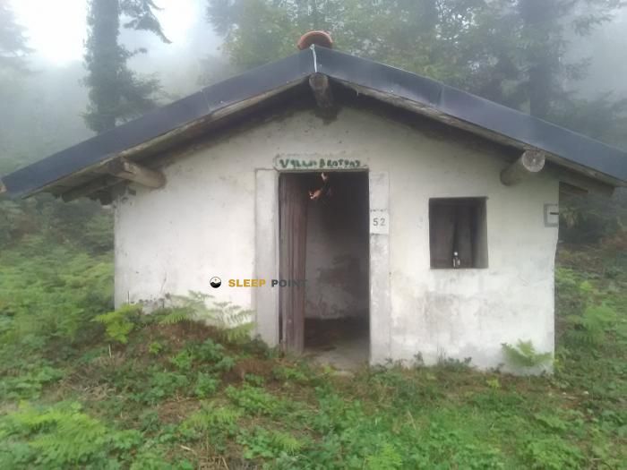
The Cabane de la Forge refuge acts as a base camp for the summits and routes of puilaurens, limoux, aude, occitania, francia metropolitana, francia. At 930 meters of elevation, its coordinates (42.831, 2.297) represent safety after a long day of effort.

See more
See more
Usuario

Lucas Martinez

Premium user

Live weather: Cabane de la Forge

The current weather in Cabane de la Forge indicates a temperature of 14°C, although the 8.8 km/h wind makes it feel like 13.8°C. Watch out for gusts of 26.3 km/h. The snow altitude (freezing level 0°) is around 4480 m and today we will reach a high of 18.5°C.
Temperature

14°C

Feels like: 13.8°C
Wind

8.8 km/h

Gusts: 26.3 km/h
Freezing level 0°

4480 m

Snow line
Sky & UV

UV 0

Clouds: 100%

Next 48 hours evolution

7-day forecast

04/06
18.5° 9.6°
12.7 mm 23 km/h UV máx: 4.7
06:13 21:24
05/06
14.5° 7.8°
0 mm 21.2 km/h UV máx: 7.25
06:13 21:25
06/06
22.8° 8.9°
0.2 mm 14.6 km/h UV máx: 7.3
06:12 21:26
07/06
24.7° 10.1°
0 mm 10.1 km/h UV máx: 6.85
06:12 21:26
08/06
17° 11.6°
2.1 mm 21.2 km/h UV máx: 7.05
06:12 21:27
09/06
13.9° 9.2°
0.3 mm 25.5 km/h UV máx: 5.2
06:12 21:27
10/06
19.5° 8.3°
0 mm 14.7 km/h UV máx: 7.45
06:12 21:28

Planning and coat

Cabane de la Forge is located in the surroundings of Puilarens, in the Aude, within Occitania, at about 930 meters altitude. With the available data, the most useful thing is to understand it as a point of protection in half a forest mountain, in an area where the day can change a lot if wind, rain or fog enter. It is not associated here with specific marked routes, so it is appropriate to raise access with basic navigation, time margin and sufficient autonomy.

The next relief combines lomas and small highlights as Tic de Ramonet , very close, or Serre de la Quière . They are not large pirenaic summits, but they are references that help to read the land and place the cabin within a network of local steps between sides of the sector. In this context, the shelter can serve to divide a short journey, protect itself on an unstable day, or support the mountains surrounding the Puilarens valley, also dominated by the rocky spur where the Puilarens castle rises.

Access and precautions

The approach should be understood as mountainous, even if the altitude is not high. The abundant forest in the area can close visual references. If time gets worse, orientation becomes important. It also changes the perception of effort, especially in wet or low-visibility terrain. That is why it is important not to rush the light and to carry out simple planning, without relying on unconfirmed links.

As for water, the invented sources are more than 3 kilometres away, so it is not appropriate to have immediate supply next to the shelter. For an exit through this sector of the coastal country, it is wise to go out with sufficient water and to review the actual state of access and the environment before the day.

Nearby peaks

Col des Cerises

Altitude not available
Lat: 42.846 Lon: 2.2424

La Pique de Bec

Altitude not available
Lat: 42.8708 Lon: 2.2657

Serre des Aiguilles

815 m
Lat: 42.8002 Lon: 2.2862

Serre de la Quière

1029 m
Lat: 42.8023 Lon: 2.3296

Roque de Méric

843 m
Lat: 42.8429 Lon: 2.3357

Tuc de Ramonet

912 m
Lat: 42.825 Lon: 2.3073

Roc du Corbeau

855 m
Lat: 42.8442 Lon: 2.3537

Tuc d'En Guinxe

904 m
Lat: 42.8241 Lon: 2.3195

Nearby water fountains

Fuente

3.01 Km
Lat: 42.8241 Lon: 2.3195

Fuente

3.39 Km
Lat: 42.8241 Lon: 2.3195

Fuente

3.4 Km
Lat: 42.8241 Lon: 2.3195

Fuente

3.41 Km
Lat: 42.8241 Lon: 2.3195

Fuente

3.42 Km
Lat: 42.8241 Lon: 2.3195

Fuente

4.18 Km
Lat: 42.8241 Lon: 2.3195

Font d'Amont

5.76 Km
Lat: 42.8241 Lon: 2.3195

Fuente

5.88 Km
Lat: 42.8241 Lon: 2.3195
FAQ

Frequently asked questions

Pregunta frecuente
In which municipality or region is the Cabane de la Forge refuge located?
This refuge is located within the municipality of Puilaurens, belonging to the community or region of Occitania.
Pregunta frecuente
Are there other mountain refuges near Cabane de la Forge?
Yes, nearby you can find other options to spend the night or take shelter. El refugio más próximo es el Lavoir, que se encuentra a aproximadamente 3.4 km de distancia.
Pregunta frecuente
At what exact altitude is the Cabane de la Forge refuge located?
The Cabane de la Forge refuge is located at an altitude of 930 meters above sea level, in the natural surroundings of puilaurens, limoux, aude, occitania, francia metropolitana, francia.
More areas

Other areas

Collaborative

Together we improve

image

Send your photos

You can upload photos of shelters and update their status so other users know if they can go there.

Get started
Get started
image

Rate the shelter

Leave your comments to rate the shelter’s condition. In the mountains, we look after each other.

Get started
Get started
image

Add new ones

Did we miss any? Publish the shelters you know so everyone can use them.

Get started
Get started
Download for free from the Apple App Store and Play Store.

Download the app and start looking for the shelter of your next adventure

Aplicación móvil para encontrar refugios de montaña donde dormir
Aplicación móvil para encontrar refugios de montaña donde dormir.
Mapa interactivo de refugios de montaña en los Pirineos dentro de la app
Mapa de refugios de montaña para senderismo y trekking en la app.
Pantalla con información de refugio de montaña con altitud capacidad y servicios
Pantalla con información de refugio de montaña con altitud capacidad y servicios.
Detalles de refugio de montaña con servicios y meteorología en aplicación móvil
Detalles de refugio de montaña con servicios y meteorología en aplicación móvil.
Aplicación para explorar refugios de montaña mediante mapa interactivo
Aplicación para explorar refugios de montaña mediante mapa interactivo.
Ficha completa de refugio de montaña con opiniones y servicios
Ficha completa de refugio de montaña con opiniones y servicios.
Información detallada de refugio en app para montañeros
Información detallada de refugio en app para montañeros.
Listado de refugios de montaña para senderismo y trekking
Listado de refugios de montaña para senderismo y trekking.
Explorar refugios de montaña desde una aplicación móvil
Explorar refugios de montaña desde una aplicación móvil.