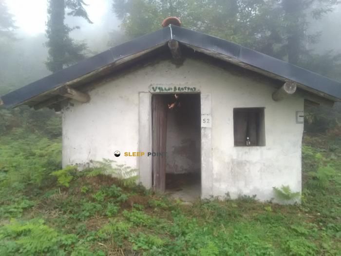
Mountain refuge Abri bus
We have it listed in the app!
We have it listed in the app!


Protected by the wild surroundings of abri bus, d 307, laprade, cailla, limoux, aude, occitania, francia metropolitana, 11140, francia, the Abri bus refuge is your best ally at 498 meters of elevation. Once you reach its coordinates (42.813, 2.202), you can enjoy a well-deserved mountain rest.
15.5°C
Feels like: 14.9°C5 km/h
Gusts: 6.1 km/h4430 m
Snow lineUV 0
Clouds: 99% 9.9 mm
 16.4 km/h
 UV máx: 4.55
 06:14
06:14
 21:25
0 mm
14.8 km/h
UV máx: 7.55
06:13
21:25
1.2 mm
9.7 km/h
UV máx: 7.25
06:13
21:26
0 mm
7.1 km/h
UV máx: 7.2
06:13
21:27
1.2 mm
21.6 km/h
UV máx: 7.8
06:12
21:27
3.9 mm
25.3 km/h
UV máx: 5.15
06:12
21:28
0 mm
13.2 km/h
UV máx: 7.45
06:12
21:28
21:25
0 mm
14.8 km/h
UV máx: 7.55
06:13
21:25
1.2 mm
9.7 km/h
UV máx: 7.25
06:13
21:26
0 mm
7.1 km/h
UV máx: 7.2
06:13
21:27
1.2 mm
21.6 km/h
UV máx: 7.8
06:12
21:27
3.9 mm
25.3 km/h
UV máx: 5.15
06:12
21:28
0 mm
13.2 km/h
UV máx: 7.45
06:12
21:28
Abri bus fits above all as a point of passage and light guard in the environment of Chair inside the Aude. Its position, at 498 meters, places it closer to a logic of link between valleys and small reliefs than to a high shelter: from here it makes sense the movements between Quillan, Puivert, Puilarens and Quirbajou, in an area where itinerary decisions depend more on the continuity of the journey than on a single summit.
This function is seen in the proximity of several signposted routes. The SC 06N and SC 07N tracks connect the Bugarach and Quillan with Puivert, while SC 06S and SC 07S link Puilarens to Quirbajou and continue to the same axis. Local itineraries such as the Brenac- Lasserre- Gourgaoura path or the Brenac Col route to Nez de l'Homme and Roc de Capio are closer, useful to understand the immediate relief: hills, lagoons and highlights that articulate the passage between small basins and secondary cords. In this context, this coat can serve to break a day, cover a transition between stages or have a fixed point of reference on a cross-mountain journey.
The nearby terrain combines valley bottom and modest but marked elevations, with references such as Suc de la Serre , Pech Pelat or Roc de la Trébine , which help to focus on the map without turning the place into an alpine base. For logistics, it is appropriate to maintain an autonomous approach: there is a source at about 400 meters, reasonable distance on the paper but it does not replace the prior check of the water or the actual state of the coat. Because of its simple nature and its location along with several lines, it is more useful for those who need continuity of route and good reading of the territory than for those who seek conventional shelter services.


Download the app and start looking for the shelter of your next adventure


Find a place to sleep before night falls.