Mountain refuge Cabane de l'Arcelin
We have it listed in the app!
We have it listed in the app!


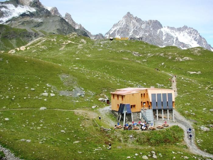
The mountains of refuge de l'arcelin, sentier notre-dame-des-anges, l'arcelin, orelle, saint-jean-de-maurienne, saboya, auvergne-rhône-alpes, francia metropolitana, 73140, francia hide essential places like the Cabane de l'Arcelin refuge. Situated at an elevation of 2030 meters, it offers protection and rest. Its exact coordinates are 45.235, 6.556.
7.6°C
Feels like: 4°C8.7 km/h
Gusts: 24.1 km/h4110 m
Snow lineUV 0
Clouds: 99% 28.2 mm
 16.2 km/h
 UV máx: 6.8
 05:47
05:47
 21:16
0.8 mm
12.5 km/h
UV máx: 5.85
05:47
21:17
0 mm
13.3 km/h
UV máx: 8.05
05:47
21:17
0 mm
13.7 km/h
UV máx: 8
05:46
21:18
1.2 mm
12.8 km/h
UV máx: 6.95
05:46
21:19
1.2 mm
14.8 km/h
UV máx: 4.8
05:46
21:19
0.3 mm
8.3 km/h
UV máx: 7.8
05:45
21:20
21:16
0.8 mm
12.5 km/h
UV máx: 5.85
05:47
21:17
0 mm
13.3 km/h
UV máx: 8.05
05:47
21:17
0 mm
13.7 km/h
UV máx: 8
05:46
21:18
1.2 mm
12.8 km/h
UV máx: 6.95
05:46
21:19
1.2 mm
14.8 km/h
UV máx: 4.8
05:46
21:19
0.3 mm
8.3 km/h
UV máx: 7.8
05:45
21:20
At 2030 meters, the Cabane de l'Arcelin It fits better in long-time planning than in an improvised valley stop. Its location at the end of Orelle, in Savoya, places it within a useful sector for those who move on routes of continuity such as the GR 55 or Tour du Mont Thabor where a free shelter can be used to fail stages and gain margin in the face of time changes or accumulated tiredness. The immediate environment is clearly mountainous, with high relief around and nearby summits such as the Cime de Caron or the Mont Bréquin, which helps to read that it is a point exposed to the high environment rather than a coat close to services.
It may also have an interest in supporting tours to the Lac du Lou, although its main role seems to be that of a safe passage in an area where it is appropriate to manage well effort, water and orientation. There are no sources close to the shelter: the available references are more than 6 km away, so it is reasonable to leave with sufficient autonomy and not to have immediate supply in the vicinity. The same logic applies to the rest of the logistics: as it is a relatively isolated mountain site, it is worth reviewing mapping, weather and itinerary status before proposing a night or a journey linked by this sector of Auvergne-Rhône- Alpes.


📏 6.8 Km
⛰️ 2035 m

📏 8.7 Km
⛰️ 2230 m

📏 9 Km
⛰️ 1680 m

📏 9.2 Km
⛰️ 1985 m

📏 10 Km
⛰️ 1700 m
📏 10.1 Km
⛰️ 2474 m

📏 10.1 Km
⛰️ 2000 m

📏 10.4 Km
⛰️ 1850 m
Download the app and start looking for the shelter of your next adventure


Find a place to sleep before night falls.


