Mountain refuge Cabane Barrage du Tech

We have it listed in the app!


            Mountain refuge Cabane Barrage du Tech in cabane du barrage du tech, route d'aste, arrens-marsous, argelès-gazost, altos pirineos, occitania, francia metropolitana, 65400, francia
Five orange stars in a horizontal row representing a five-star rating.

Cabane Barrage du Tech

Lat: 42.916xxx – Lon: -0.252xxx
📍 cabane du barrage du tech, route d'aste, arrens-marsous, argelès-gazost, altos pirineos, occitania, francia metropolitana, 65400, francia
Cabane Barrage du Tech

If you are planning a route through cabane du barrage du tech, route d'aste, arrens-marsous, argelès-gazost, altos pirineos, occitania, francia metropolitana, 65400, francia, the Cabane Barrage du Tech refuge is a must-stop. Located at 1260 m above sea level, it offers hikers and climbers a safe place to regain strength. Save its coordinates (42.916, -0.252) in your GPS to stay on course during your journey.

See more
See more
Usuario

Lucas Martinez

Premium user

Live weather: Cabane Barrage du Tech

Before heading to Cabane Barrage du Tech, check the weather: we currently have 11.2°C (feels like 11.1°C). With wind gusts reaching 2.5 km/h and a freezing level around 4090 meters, the daytime high will not exceed 12.8°C.
Temperature

11.2°C

Feels like: 11.1°C
Wind

3.4 km/h

Gusts: 2.5 km/h
Freezing level 0°

4090 m

Snow line
Sky & UV

UV 0.55

Clouds: 100%

Next 48 hours evolution

7-day forecast

04/06
12.8° 6.8°
6.65 mm 12.8 km/h UV máx: 1.85
06:23 21:35
05/06
12.4° 3.8°
0.6 mm 10.1 km/h UV máx: 7.85
06:23 21:35
06/06
16° 8.9°
0.7 mm 8.7 km/h UV máx: 6.45
06:22 21:36
07/06
23° 9.7°
0 mm 4 km/h UV máx: 7.8
06:22 21:37
08/06
16.9° 11.2°
4.2 mm 9.5 km/h UV máx: 8.05
06:22 21:37
09/06
10.9°
1.8 mm 8.2 km/h UV máx: 4.75
06:22 21:38
10/06
16.8° 5.4°
0 mm 7.9 km/h UV máx: 7.65
06:21 21:39

Between summits and traverses of the Val d'Azun

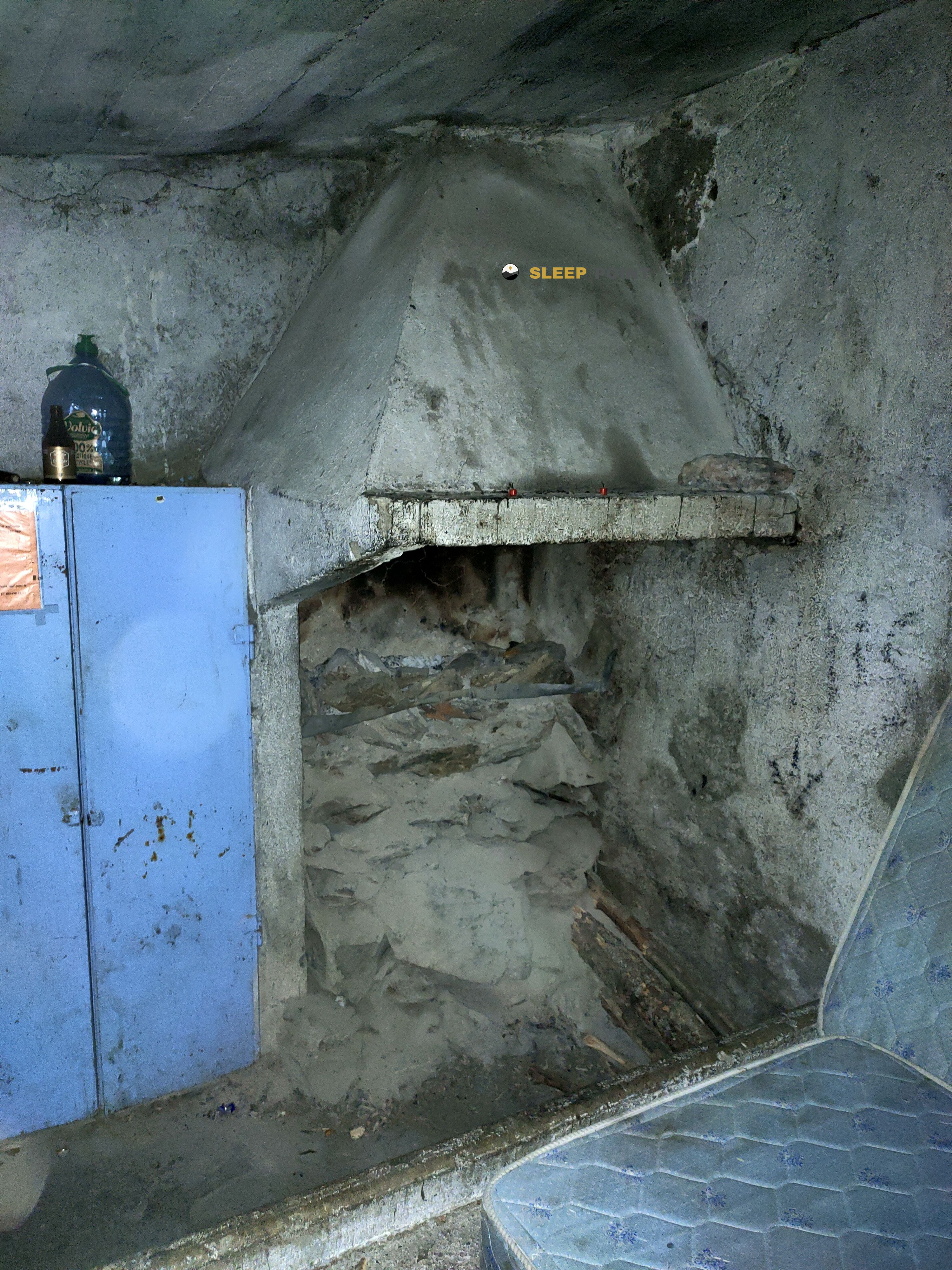
Under the line of summits that form the Pic des Taillades , Pic de L'Arcoèche or Pic du Midi d'Arrens , Cabane Barrage du Tech is still low in altitude in a mountain strip for the Pyrenees, at 1260 meters, but already clearly linked to continuity routes. In the sector of Arensen-Marsous, this coat fits mainly as a point of passage or logistical support on long routes, as the area converge the HRP , GR 10 and GR 101 . More than an isolated destination, it works better as an intermediate reference to divide days, reorganize a journey or face with margin the sections that go back to lakes and hills of the environment.

The access is located in the surroundings of the barrage du Tech, which relates it to a valley open at the beginning but increasingly mountainous as you gain height towards itineraries like those of Lac de Pouey- Laün or Lac du Plaa de Prat . This transition should be read well when planning effort and time, because the cabin is not on strict high mountain terrain, but in an area where weather and stage length can quickly change the character of the day. The registered sources appear more than 5 km away, so it is not appropriate to have near water without prior verification. In a prudent planning, it is important to arrive with basic autonomy and use this mountain shelter as route support, not as a place to take the logistics for granted.

Hiking routes from the refuge

HRP

Étape 12

↔ Variable distance
HRP

HRP Étape 13

↔ Variable distance
GR 101

Chemin de l'Ouest de Bigorre

↔ Variable distance
Local

Lac de Pouey-Laün

↔ Variable distance
Local

Lac du Plaa de Prat

↔ Variable distance
GR 10

La traversée des Pyrénées - sec.7

↔ Variable distance
Local

Tour de la Vallée d'Ossau - Étape 6 Col d'Aubisque / Eaux-Bonnes par Gourette

↔ Variable distance
Ossau

Le Lac d'Anglas

↔ 7.5 km

Nearby peaks

Pic des Taillades

2691 m
Lat: 42.9309 Lon: -0.2838

Pic des Tourettes

2771 m
Lat: 42.8895 Lon: -0.3153

Pic de L'Arcoèche

2465 m
Lat: 42.8905 Lon: -0.2505

Pic de Clos Bédout

2461 m
Lat: 42.8688 Lon: -0.25

Pic du Midi d'Arrens

2267 m
Lat: 42.9264 Lon: -0.2109

Pic de Mousquès

2222 m
Lat: 42.9224 Lon: -0.2149

Cap d'Aout

1654 m
Lat: 42.9678 Lon: -0.2585

Pic de Gabizos

2639 m
Lat: 42.9394 Lon: -0.2792

Nearby water fountains

Fuente

5.04 Km
Lat: 42.9394 Lon: -0.2792

Fuente

5.15 Km
Lat: 42.9394 Lon: -0.2792

Fuente

5.15 Km
Lat: 42.9394 Lon: -0.2792

Fuente

5.41 Km
Lat: 42.9394 Lon: -0.2792

Fuente

5.41 Km
Lat: 42.9394 Lon: -0.2792

Fuente

5.48 Km
Lat: 42.9394 Lon: -0.2792

Fuente

5.69 Km
Lat: 42.9394 Lon: -0.2792

Fuente

6.85 Km
Lat: 42.9394 Lon: -0.2792
FAQ

Frequently asked questions

Pregunta frecuente
Are there other mountain refuges near Cabane Barrage du Tech?
Yes, nearby you can find other options to spend the night or take shelter. El refugio más próximo es el Cuyeou de Labet, que se encuentra a aproximadamente 0.8 km de distancia.
Pregunta frecuente
At what exact altitude is the Cabane Barrage du Tech refuge located?
The Cabane Barrage du Tech refuge is located at an altitude of 1260 meters above sea level, in the natural surroundings of cabane du barrage du tech, route d'aste, arrens-marsous, argelès-gazost, altos pirineos, occitania, francia metropolitana, 65400, francia.
Pregunta frecuente
What are the GPS coordinates of the Cabane Barrage du Tech refuge?
To locate the Cabane Barrage du Tech refuge on your GPS or map, use the following coordinates: Latitude 42.916 and Longitude -0.252.
More areas

Other areas

Collaborative

Together we improve

image

Send your photos

You can upload photos of shelters and update their status so other users know if they can go there.

Get started
Get started
image

Rate the shelter

Leave your comments to rate the shelter’s condition. In the mountains, we look after each other.

Get started
Get started
image

Add new ones

Did we miss any? Publish the shelters you know so everyone can use them.

Get started
Get started
Download for free from the Apple App Store and Play Store.

Download the app and start looking for the shelter of your next adventure

Aplicación móvil para encontrar refugios de montaña donde dormir
Aplicación móvil para encontrar refugios de montaña donde dormir.
Mapa interactivo de refugios de montaña en los Pirineos dentro de la app
Mapa de refugios de montaña para senderismo y trekking en la app.
Pantalla con información de refugio de montaña con altitud capacidad y servicios
Pantalla con información de refugio de montaña con altitud capacidad y servicios.
Detalles de refugio de montaña con servicios y meteorología en aplicación móvil
Detalles de refugio de montaña con servicios y meteorología en aplicación móvil.
Aplicación para explorar refugios de montaña mediante mapa interactivo
Aplicación para explorar refugios de montaña mediante mapa interactivo.
Ficha completa de refugio de montaña con opiniones y servicios
Ficha completa de refugio de montaña con opiniones y servicios.
Información detallada de refugio en app para montañeros
Información detallada de refugio en app para montañeros.
Listado de refugios de montaña para senderismo y trekking
Listado de refugios de montaña para senderismo y trekking.
Explorar refugios de montaña desde una aplicación móvil
Explorar refugios de montaña desde una aplicación móvil.