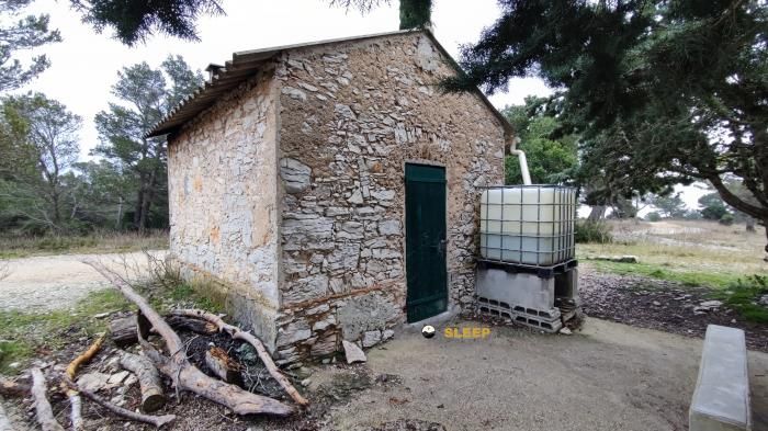
Mountain refuge Abri des Mèdes
We have it listed in the app!
We have it listed in the app!


With a privileged location in abri des mèdes, chemin du cap des mèdes, hyères, arrondissement de toulon, var, provenza-alpes-costa azul, francia metropolitana, 83400, francia, the Abri des Mèdes refuge awaits you at 10 meters of altitude. Note its position (43.025, 6.241) before starting your route through the mountain range or massif.
20.2°C
Feels like: 17.5°C23.9 km/h
Gusts: 36.4 km/h4380 m
Snow lineUV 0
Clouds: 100% 0.1 mm
 46.2 km/h
 UV máx: 7.7
 05:57
05:57
 21:09
0.2 mm
45.8 km/h
UV máx: 6.75
05:56
21:10
0 mm
32 km/h
UV máx: 7.55
05:56
21:11
0 mm
16.7 km/h
UV máx: 7.4
05:56
21:11
0 mm
13.2 km/h
UV máx: 7.15
05:55
21:12
0 mm
23.4 km/h
UV máx: 6.9
05:55
21:12
0 mm
11.3 km/h
UV máx: 7.4
05:55
21:13
21:09
0.2 mm
45.8 km/h
UV máx: 6.75
05:56
21:10
0 mm
32 km/h
UV máx: 7.55
05:56
21:11
0 mm
16.7 km/h
UV máx: 7.4
05:56
21:11
0 mm
13.2 km/h
UV máx: 7.15
05:55
21:12
0 mm
23.4 km/h
UV máx: 6.9
05:55
21:12
0 mm
11.3 km/h
UV máx: 7.4
05:55
21:13
In the field of Cap des Mèdes within the term of Hyères and very close to the coastal route of the island of Porquerolles , Abri des Mèdes It appears on a very low level, just 10 meters above the sea. This position completely separates it from the model of the Pyrenean alpine shelter: here the reference is not the high mountain, but an insular and exposed terrain, where the orientation depends more on the coastal roads, the wind changes and the continuity of the day rather than the gap.
His practical interest is in supporting or retreating points during such tours as the Circuit du Levant, the Circuit du Midi, the Circuit du Mistral, the Circuit du couchant or the sentier du Littoral towards La Tour Fondue. It can also fit as an intermediate coat on foot through the eastern end of the island, an area where small elevations such as La Poncha dau Bón Dieu, Pouncho dou Bouan Diéu or the Monts Saranier help to understand the relief, although not to mention entity ascension. More than a base for summits, it works as a passing reference in an open and maritime environment.
It is appropriate to plan the exit with autonomy. The registered sources are not immediately left and the nearest round several kilometres, so it is not wise to have water in the vicinity of the coat. In hot days or with strong wind, that detail weighs more than altitude. Anyone who reaches this point should provide sufficient water, protection from coastal exposure and scope to reorganize the route if conditions change during the journey.


📏 26.8 Km
⛰️ 160 m

📏 34.7 Km
⛰️ 637 m

📏 53.1 Km
⛰️ 675 m
📏 54.7 Km
⛰️ 500 m

📏 54.9 Km
⛰️ 1040 m

📏 55.2 Km
⛰️ 735 m

📏 55.2 Km
⛰️ 650 m

📏 56.3 Km
⛰️ 480 m
Download the app and start looking for the shelter of your next adventure


Find a place to sleep before night falls.


