Mountain refuge Cabanon du Marquis
We have it listed in the app!
We have it listed in the app!
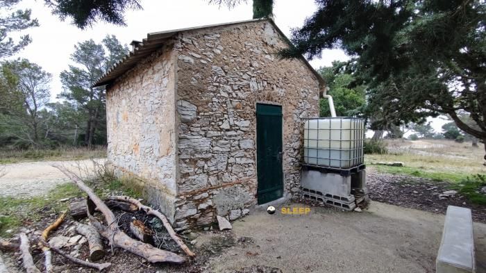

Located in the heart of chemin du château, les bastides, roquefort-la-bédoule, marseille, bocas del ródano, provenza-alpes-costa azul, francia metropolitana, 13830, francia, the Cabanon du Marquis refuge offers shelter at 500 meters above sea level. Ideal for trekking and nature lovers, this mountain shelter (Lat: 43.242, Lon: 5.636) is the perfect starting point or resting place for local routes.
16.5°C
Feels like: 14°C10.2 km/h
Gusts: 28.4 km/h4370 m
Snow lineUV 0
Clouds: 100% 15.6 mm
 34.3 km/h
 UV máx: 7.75
 05:58
05:58
 21:12
0.4 mm
26.5 km/h
UV máx: 7.2
05:58
21:13
0 mm
17.3 km/h
UV máx: 7.35
05:58
21:14
0 mm
15.7 km/h
UV máx: 7.6
05:57
21:14
0 mm
13.2 km/h
UV máx: 7.75
05:57
21:15
0.3 mm
27 km/h
UV máx: 7.3
05:57
21:16
0 mm
20.7 km/h
UV máx: 7.45
05:57
21:16
21:12
0.4 mm
26.5 km/h
UV máx: 7.2
05:58
21:13
0 mm
17.3 km/h
UV máx: 7.35
05:58
21:14
0 mm
15.7 km/h
UV máx: 7.6
05:57
21:14
0 mm
13.2 km/h
UV máx: 7.75
05:57
21:15
0.3 mm
27 km/h
UV máx: 7.3
05:57
21:16
0 mm
20.7 km/h
UV máx: 7.45
05:57
21:16
Cabanon du Marquis forces to plan the day well. At about 500 meters of altitude, around Roquefort-la-Bédoule , works mainly as a support in a dry and open relief, closer to the coastal saws of Provence than to the classic high mountain shelter. This position places it in a useful strip to link half-mountain roads, low cords and loops that require continuity of march rather than extreme levels.
Your practical interest appears when you read the map of the area. On the one hand, it allows to fit routes linked to the GR 98 On the other hand, it is within a sector where routes such as the Sentier du Cap Canaille or links to hills and nearby mountains. Cimas close as Le Montobier , Le Télégraphe or Mont Cruvelier help to understand the terrain: a succession of modest elevations, but sufficient to accumulate ups, orientation changes and sections exposed to the sun and wind.
In this context, the shelter can serve to start a long route or not to concentrate the whole march on a single day. Not so much because of the altitude, but because of the combination of variable paths, broken ground and links that can extend the route according to the chosen route. Whoever uses it as a point of support for hiking in the area should bring a clear idea of the route and the exit alternatives to Roquefort-la-Bédoule and the next cords.
The water deserves attention. The nearest registered sources are more than 2.5 km away, so it is not appropriate to have immediate supply next to the shelter. In a Mediterranean area, this weighs as much as the gap in organizing the stage. It is also reasonable to provide for basic autonomy and to consult the state of the itinerary before leaving, especially if it is intended to link long sections of GR or to combine several paths on the same day.


📏 1.8 Km
⛰️ 480 m

📏 8.2 Km
⛰️ 650 m

📏 8.4 Km
⛰️ 735 m

📏 8.7 Km
⛰️ 565 m

📏 8.8 Km
⛰️ 1040 m

📏 9.2 Km
⛰️ 675 m

📏 10.6 Km
⛰️ 190 m

📏 11.7 Km
⛰️ 70 m
Download the app and start looking for the shelter of your next adventure


Find a place to sleep before night falls.


