Mountain refuge Abri de Saint-Côme

We have it listed in the app!


            Mountain refuge Abri de Saint-Côme in rue brulée, saint-côme-d'olt, rodez, aveyron, occitania, francia metropolitana, 12500, francia
Five orange stars in a horizontal row representing a five-star rating.

Abri de Saint-Côme

Lat: 44.515xxx – Lon: 2.815xxx
📍 rue brulée, saint-côme-d'olt, rodez, aveyron, occitania, francia metropolitana, 12500, francia
Abri de Saint-Côme

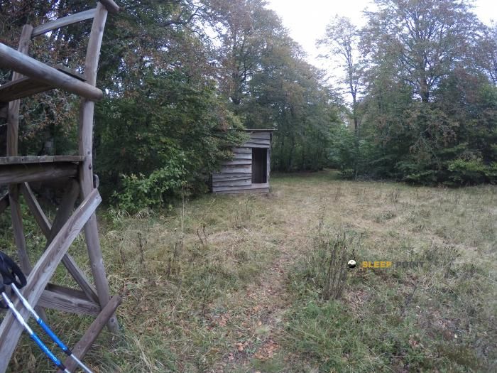
Conquering the trails of rue brulée, saint-côme-d'olt, rodez, aveyron, occitania, francia metropolitana, 12500, francia is easier with the Abri de Saint-Côme refuge. Located at 373 m (coordinates 44.515, 2.815), it is the ideal shelter against harsh mountain weather.

See more
See more
Usuario

Lucas Martinez

Premium user

Live weather: Abri de Saint-Côme

Before heading to Abri de Saint-Côme, check the weather: we currently have 14.1°C (feels like 14.1°C). With wind gusts reaching 6.8 km/h and a freezing level around 4010 meters, the daytime high will not exceed 16°C.
Temperature

14.1°C

Feels like: 14.1°C
Wind

3.5 km/h

Gusts: 6.8 km/h
Freezing level 0°

4010 m

Snow line
Sky & UV

UV 0

Clouds: 100%

Next 48 hours evolution

7-day forecast

04/06
16° 13.6°
19 mm 15.2 km/h UV máx: 1.1
06:05 21:28
05/06
18.7° 10.8°
0 mm 16 km/h UV máx: 7.05
06:05 21:29
06/06
22.1° 9.9°
0 mm 19.8 km/h UV máx: 7.3
06:04 21:30
07/06
24.5° 11.5°
0 mm 5.2 km/h UV máx: 6.85
06:04 21:30
08/06
24.9° 15.5°
1.5 mm 13 km/h UV máx: 7.55
06:04 21:31
09/06
21° 15°
2.1 mm 20.2 km/h UV máx: 6.65
06:03 21:32
10/06
24.9° 10.8°
0 mm 6.3 km/h UV máx: 7.3
06:03 21:32

As you advance along the roads that link Saint-Côme-d 'Olt with the surroundings of Espalion and the lomas of Aveyron, the Abri de Saint-Côme It works above all as a reference of passage and withdrawal within a much more humanized terrain than alpine. It is in the rue Brulée, only 373 meters of altitude, within the town's centre marked by the historical passage of walking itineraries, so that it fits better in liaison days, soft voyages or half-distance trails than in mountain ascension. In this context, your practical interest is well understood when looking at the map: it is close to trace as the GR 620 and local tours such as Sentier Aubrac - Abbaye de Bonneval - Espalion, La Voie du Rail or La Boralde de de Flaujac, which places it in a useful network to reorganize the march, shorten a stage or resolve a retreat to the village.

The orientation in the area is relatively simple if the very core of Saint-Côme-d'Olt and the corridor to Espalion are taken as a reference, but it is appropriate not to confuse this coat with an isolated mountain shelter. Its value is in the transition between roads, rural heritage and wavy relief. For logistics, there is a very close source, about 130 meters, and another to just over 300 meters, a useful data to manage water without too far from the itinerary. However, since there are no details of equipment or conditions of use, it is reasonable to maintain basic autonomy and to check the state of the place before considering it as the main support of the day.

Hiking routes from the refuge

Local

Sentier Aubrac - Abbaye de Bonneval - Espalion

↔ Variable distance
GR 620

Horizons et Clochers du Rouergue

↔ Variable distance
Local

La Voie du Rail

↔ Variable distance
Local

La Boralde de Flaujac

↔ Variable distance

Nearby water fountains

Fuente

132 m
Lat: 0 Lon: 0

Fuente

333 m
Lat: 0 Lon: 0

Fuente

2.68 Km
Lat: 0 Lon: 0

Fuente

2.72 Km
Lat: 0 Lon: 0

Fuente

3.57 Km
Lat: 0 Lon: 0

Fuente

3.75 Km
Lat: 0 Lon: 0

Fuente

3.77 Km
Lat: 0 Lon: 0

Fuente

3.99 Km
Lat: 0 Lon: 0
FAQ

Frequently asked questions

Pregunta frecuente
In which municipality or region is the Abri de Saint-Côme refuge located?
This refuge is located within the municipality of Saint-Côme-d'Olt, belonging to the community or region of Occitania.
Pregunta frecuente
Are there other mountain refuges near Abri de Saint-Côme?
Yes, nearby you can find other options to spend the night or take shelter. El refugio más próximo es el Four à pain de l'Estrade, que se encuentra a aproximadamente 6.7 km de distancia.
Pregunta frecuente
At what exact altitude is the Abri de Saint-Côme refuge located?
The Abri de Saint-Côme refuge is located at an altitude of 373 meters above sea level, in the natural surroundings of rue brulée, saint-côme-d'olt, rodez, aveyron, occitania, francia metropolitana, 12500, francia.
More areas

Other areas

Collaborative

Together we improve

image

Send your photos

You can upload photos of shelters and update their status so other users know if they can go there.

Get started
Get started
image

Rate the shelter

Leave your comments to rate the shelter’s condition. In the mountains, we look after each other.

Get started
Get started
image

Add new ones

Did we miss any? Publish the shelters you know so everyone can use them.

Get started
Get started
Download for free from the Apple App Store and Play Store.

Download the app and start looking for the shelter of your next adventure

Aplicación móvil para encontrar refugios de montaña donde dormir
Aplicación móvil para encontrar refugios de montaña donde dormir.
Mapa interactivo de refugios de montaña en los Pirineos dentro de la app
Mapa de refugios de montaña para senderismo y trekking en la app.
Pantalla con información de refugio de montaña con altitud capacidad y servicios
Pantalla con información de refugio de montaña con altitud capacidad y servicios.
Detalles de refugio de montaña con servicios y meteorología en aplicación móvil
Detalles de refugio de montaña con servicios y meteorología en aplicación móvil.
Aplicación para explorar refugios de montaña mediante mapa interactivo
Aplicación para explorar refugios de montaña mediante mapa interactivo.
Ficha completa de refugio de montaña con opiniones y servicios
Ficha completa de refugio de montaña con opiniones y servicios.
Información detallada de refugio en app para montañeros
Información detallada de refugio en app para montañeros.
Listado de refugios de montaña para senderismo y trekking
Listado de refugios de montaña para senderismo y trekking.
Explorar refugios de montaña desde una aplicación móvil
Explorar refugios de montaña desde una aplicación móvil.