Mountain refuge Abri de la Vaysse

We have it listed in the app!


            Mountain refuge Abri de la Vaysse in abri de la vaysse, ancienne voie romaine (via agrippa), saint-chély-d'aubrac, rodez, aveyron, occitania, francia metropolitana, 12470, francia
Five orange stars in a horizontal row representing a five-star rating.

Abri de la Vaysse

Lat: 44.6xxx – Lon: 2.991xxx
📍 abri de la vaysse, ancienne voie romaine (via agrippa), saint-chély-d'aubrac, rodez, aveyron, occitania, francia metropolitana, 12470, francia
Abri de la Vaysse

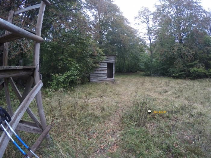
Discover the Abri de la Vaysse refuge, an alpine shelter located at 1308 meters in the area of abri de la vaysse, ancienne voie romaine (via agrippa), saint-chély-d'aubrac, rodez, aveyron, occitania, francia metropolitana, 12470, francia. Whether you are on a multi-day trek or a day hike, this point (44.6, 2.991) will provide the peace and shelter you seek in the mountains.

See more
See more
Usuario

Lucas Martinez

Premium user

Live weather: Abri de la Vaysse

Before heading to Abri de la Vaysse, check the weather: we currently have 9.8°C (feels like 8.5°C). With wind gusts reaching 20.9 km/h and a freezing level around 3470 meters, the daytime high will not exceed 10.2°C.
Temperature

9.8°C

Feels like: 8.5°C
Wind

7.3 km/h

Gusts: 20.9 km/h
Freezing level 0°

3470 m

Snow line
Sky & UV

UV 0.15

Clouds: 100%

Next 48 hours evolution

7-day forecast

04/06
10.2° 6.9°
18.5 mm 21.4 km/h UV máx: 1.6
06:04 21:28
05/06
11.8° 3.9°
0 mm 19 km/h UV máx: 7.4
06:04 21:28
06/06
15.1°
0 mm 24.9 km/h UV máx: 7.35
06:03 21:29
07/06
18.2° 6.7°
0 mm 8.8 km/h UV máx: 7.15
06:03 21:30
08/06
21.4° 13°
6.9 mm 20.3 km/h UV máx: 7.6
06:03 21:31
09/06
14° 8.5°
0.9 mm 22.1 km/h UV máx: 6.7
06:02 21:31
10/06
15.2° 5.9°
0 mm 15.8 km/h UV máx: 7.45
06:02 21:32

Orientation in the Aubrac

In the term of Saint-Chély-d'Aubrac, within Occitania and on the route of the ancient Roman Via Agrippa, the Abri de la Vaysse is located in an area of plateau and open lomas of the Aubrac. The nearby relief does not respond to an alpine environment, but it does respond to an exposed, wide terrain with scattered references, where small elevations such as La Roque, Puech du Pommier or Roc de Campiels help to understand their position in the landscape.

More than as a destination in itself, this coat fits as a support for walking through the sector. Its location relates to local hiking itineraries and to traces of discovery of the environment of Saint-Chély-d'Aubrac, so that it can serve to fail a day, to protect itself in case of a change of time or to add a point of reference to the plateau. It can also be useful for those who travel the Aubrac with an autonomous approach and want to link paths without relying on immediate inhabited nuclei.

Planning here depends mainly on logistics. Although there are invented sources in the area, the nearest one is more than 2 km away, so it is not appropriate to have immediate water next to the shelter. There is also not enough data to take for granted internal equipment or services, so it is reasonable to provide for basic autonomy and to consult the state of the coat before leaving. At 1308 meters, exposure to the wind, fog or rapid time changes can have a significant impact on the orientation and comfort of the march.

Hiking routes from the refuge

Local

circuit Grange du Four

↔ Variable distance
Local

9 La cascade du Déroc

↔ Variable distance
Local

Circuit Découverte

↔ 3 km
Local

Antiole

↔ Variable distance
Local

Roquecole

↔ Variable distance
Local

Sentier Aubrac - Abbaye de Bonneval - Espalion

↔ Variable distance
GR 6A

Chemin de Brameloup à Aubrac

↔ Variable distance
CSG02

CSG 02 : Nasbinals - Saint-Chély-d'Aubrac

↔ Variable distance

Nearby peaks

Puech Saint-Geniez

1271 m
Lat: 44.6224 Lon: 3.0464

Puy de Gudette

1427 m
Lat: 44.6499 Lon: 2.9771

Alte Teste

1448 m
Lat: 44.5753 Lon: 3.0524

La Roque

1303 m
Lat: 44.5834 Lon: 2.9858

Puech du Pommier

1302 m
Lat: 44.6042 Lon: 3.0039

Roc de Campiels

1354 m
Lat: 44.591 Lon: 3.0147

Puech Crémat

1375 m
Lat: 44.6054 Lon: 3.0243

Truques d'Aubrac

1440 m
Lat: 44.6421 Lon: 2.9617

Nearby water fountains

Fuente

2.46 Km
Lat: 44.6421 Lon: 2.9617

Fuente

3.05 Km
Lat: 44.6421 Lon: 2.9617

Fuente

4.14 Km
Lat: 44.6421 Lon: 2.9617

Fuente

5.53 Km
Lat: 44.6421 Lon: 2.9617

Fuente

5.57 Km
Lat: 44.6421 Lon: 2.9617

Fuente

5.58 Km
Lat: 44.6421 Lon: 2.9617

Fuente

5.61 Km
Lat: 44.6421 Lon: 2.9617

Fuente

6.17 Km
Lat: 44.6421 Lon: 2.9617
FAQ

Frequently asked questions

Pregunta frecuente
At what exact altitude is the Abri de la Vaysse refuge located?
The Abri de la Vaysse refuge is located at an altitude of 1308 meters above sea level, in the natural surroundings of abri de la vaysse, ancienne voie romaine (via agrippa), saint-chély-d'aubrac, rodez, aveyron, occitania, francia metropolitana, 12470, francia.
Pregunta frecuente
What are the GPS coordinates of the Abri de la Vaysse refuge?
To locate the Abri de la Vaysse refuge on your GPS or map, use the following coordinates: Latitude 44.6 and Longitude 2.991.
Pregunta frecuente
Is it necessary to carry a GPS to reach the Abri de la Vaysse refuge?
It is always highly recommended to carry a GPS device, a route track, or a topographic map in the mountains. You can use the coordinates 44.6, 2.991 to locate this refuge precisely.
More areas

Other areas

Collaborative

Together we improve

image

Send your photos

You can upload photos of shelters and update their status so other users know if they can go there.

Get started
Get started
image

Rate the shelter

Leave your comments to rate the shelter’s condition. In the mountains, we look after each other.

Get started
Get started
image

Add new ones

Did we miss any? Publish the shelters you know so everyone can use them.

Get started
Get started
Download for free from the Apple App Store and Play Store.

Download the app and start looking for the shelter of your next adventure

Aplicación móvil para encontrar refugios de montaña donde dormir
Aplicación móvil para encontrar refugios de montaña donde dormir.
Mapa interactivo de refugios de montaña en los Pirineos dentro de la app
Mapa de refugios de montaña para senderismo y trekking en la app.
Pantalla con información de refugio de montaña con altitud capacidad y servicios
Pantalla con información de refugio de montaña con altitud capacidad y servicios.
Detalles de refugio de montaña con servicios y meteorología en aplicación móvil
Detalles de refugio de montaña con servicios y meteorología en aplicación móvil.
Aplicación para explorar refugios de montaña mediante mapa interactivo
Aplicación para explorar refugios de montaña mediante mapa interactivo.
Ficha completa de refugio de montaña con opiniones y servicios
Ficha completa de refugio de montaña con opiniones y servicios.
Información detallada de refugio en app para montañeros
Información detallada de refugio en app para montañeros.
Listado de refugios de montaña para senderismo y trekking
Listado de refugios de montaña para senderismo y trekking.
Explorar refugios de montaña desde una aplicación móvil
Explorar refugios de montaña desde una aplicación móvil.