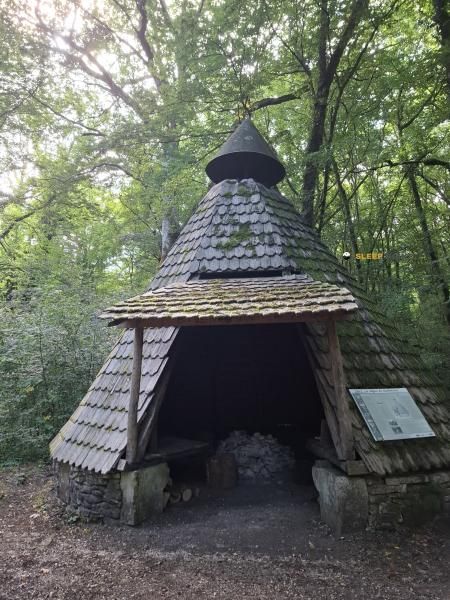
Mountain refuge Abri de la Pépinière de Montaubert
We have it listed in the app!
We have it listed in the app!


Prepare your backpack and head to abri de la pépinière de montaubert, d 428, le bas du rang, perrogney, auberive, langres, alto marne, gran este, francia metropolitana, 52160, francia. There you will find the Abri de la Pépinière de Montaubert refuge at 428 meters of elevation. An essential stop along the way (Lat: 47.773, Lon: 5.121) for any mountain enthusiast.
15.1°C
Feels like: 13°C15.7 km/h
Gusts: 27.7 km/h3510 m
Snow lineUV 0
Clouds: 100% 4.6 mm
 23.8 km/h
 UV máx: 2.4
 05:43
05:43
 21:32
0 mm
14.9 km/h
UV máx: 5.05
05:42
21:33
0.7 mm
22.2 km/h
UV máx: 6.65
05:42
21:34
0 mm
12 km/h
UV máx: 6.3
05:42
21:34
3.45 mm
12.4 km/h
UV máx: 5.45
05:41
21:35
4.5 mm
21.3 km/h
UV máx: 6.45
05:41
21:36
0 mm
13.2 km/h
UV máx: 6.8
05:41
21:36
21:32
0 mm
14.9 km/h
UV máx: 5.05
05:42
21:33
0.7 mm
22.2 km/h
UV máx: 6.65
05:42
21:34
0 mm
12 km/h
UV máx: 6.3
05:42
21:34
3.45 mm
12.4 km/h
UV máx: 5.45
05:41
21:35
4.5 mm
21.3 km/h
UV máx: 6.45
05:41
21:36
0 mm
13.2 km/h
UV máx: 6.8
05:41
21:36
The lands of Alto Marne in the Greater East region are characterized by an orography of forest plateau where important river courses such as the Aube River are born. In this half-mountain environment, near the town of Auberive and the district of Langres, dense vegetation and secondary valleys define the advance of the trails. The moderate altitude, around 428 meters, does not detract from orientation in a land where the continuity of the forest roads is the dominant tonic of the landscape.
The Abri de la Pépinière de Montaubert is strategically located for those who travel the GR 7 in its stretch between the Vosgos and the Pyrenees, serving as support in a transit area between Perrancey-les-Vieux-Moulins and La Vaseraie. Its location also facilitates access to local itineraries such as the Gorges de Vingeanne or the Tufière d'Amorey, allowing to fragment the days in this section of the Langres sector. In the absence of confirmed services and of up-to-date interior equipment, this mountain shelter should be considered purely as a basic protection structure and mapping point of reference.
Logistics planning in this area requires special attention to water supply, as the nearest sources are at a considerable distance, exceeding three kilometres from the site. In the absence of recent data on the state of the property, it is essential that the mountaineers maintain total autonomy in terms of overnight and food. The Abri de la Pépinière de Montaubert thus performs a logistical support function in a low population density environment, where weather forecasting and the control of passing times are fundamental to successfully complete the half-mountain stages on this French side.


📏 1.4 Km
⛰️ 390 m

📏 4 Km
⛰️ 450 m

📏 4.8 Km
⛰️ 360 m

📏 5.1 Km
⛰️ 400 m

📏 7.2 Km
⛰️ 365 m

📏 9.6 Km
⛰️ 440 m

📏 21.8 Km
⛰️ 418 m

📏 24.4 Km
⛰️ 425 m
Download the app and start looking for the shelter of your next adventure


Find a place to sleep before night falls.


