Mountain refuge Cabane de la Goyët

We have it listed in the app!


            Mountain refuge Cabane de la Goyët in cabane de la goyët, d 187, germaines, langres, alto marne, gran este, francia metropolitana, 52160, francia
Five orange stars in a horizontal row representing a five-star rating.

Cabane de la Goyët

Lat: 47.81xxx – Lon: 5.041xxx
📍 cabane de la goyët, d 187, germaines, langres, alto marne, gran este, francia metropolitana, 52160, francia
Cabane de la Goyët

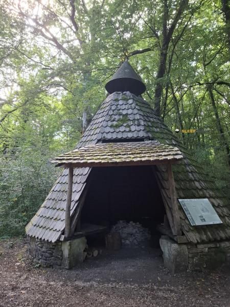
The mountains of cabane de la goyët, d 187, germaines, langres, alto marne, gran este, francia metropolitana, 52160, francia hide essential places like the Cabane de la Goyët refuge. Situated at an elevation of 365 meters, it offers protection and rest. Its exact coordinates are 47.81, 5.041.

See more
See more
Usuario

Lucas Martinez

Premium user

Live weather: Cabane de la Goyët

Alpine weather summary for Cabane de la Goyët: temperature at 15.4°C, feels like 13.1°C. Wind at 17.6 km/h with peaks of 32.4 km/h. UV index at 0 and freezing altitude at 3510 m. Maximum temperatures of 17.5°C in the coming hours.
Temperature

15.4°C

Feels like: 13.1°C
Wind

17.6 km/h

Gusts: 32.4 km/h
Freezing level 0°

3510 m

Snow line
Sky & UV

UV 0

Clouds: 99%

Next 48 hours evolution

7-day forecast

04/06
17.5° 12.9°
6.5 mm 24.2 km/h UV máx: 2.8
05:43 21:32
05/06
18.5° 10.2°
0 mm 14.8 km/h UV máx: 6.65
05:43 21:33
06/06
20.5° 11.2°
0.8 mm 22.9 km/h UV máx: 6.9
05:42 21:34
07/06
21° 11.6°
0 mm 12.1 km/h UV máx: 6.55
05:42 21:35
08/06
22.8° 13.1°
2.55 mm 13.2 km/h UV máx: 6.95
05:41 21:36
09/06
18.7° 13.5°
2.7 mm 15.6 km/h UV máx: 6.75
05:41 21:36
10/06
22° 10.2°
0 mm 10.6 km/h UV máx: 6.8
05:41 21:37

Planning a trip through the Department of Alto Marne in the region of Great East needs to identify strategic support points such as Cabane de la Goyët . Located at an altitude of 365 meters at the end of Germaines , this structure is integrated into a half mountain environment and forest areas of the Langers . Its location is key to those who travel the GR 7 in particular in the section linking the Vosgos to the Pyrenees. The climate in this area of France often presents a persistent humidity, making this shelter a valuable resource for managing rest in long-distance days. When found on a low level, the surrounding terrain alternates between forest masses and valleys, offering a functional guard that facilitates the continuity of the itinerary without the demands of the great massizos.

The Cabane de la Goyët plays a key logistical role to divide extensive stages into local itineraries such as L'Ource or the route to La Tufière d'Amorey . Because it does not have immediate water sources - the nearest catchment is more than two kilometres away - water autonomy must be ensured before reaching this point. Its position allows to move fluently between the paths of Germaines and the forest tracks that connect with the Canton of Auberive . For the mountaineer that follows the route of GR 7 , this shelter allows to reorganize the march without the need to deviate from the main route. The design of the relief, without prominent summits in the vicinity, reinforces its utility as a link and support node for cross-roads that require a rigorous planning of the revival and the passing times through this sector of northeastern France.

Hiking routes from the refuge

GR 7

Des Vosges aux Pyrénées 02, Perrancey-les-Vieux-Moulins - La Vaseraie

↔ Variable distance
Local

Le Signal de Saint-Loup

↔ Variable distance
Local

L'Ource

↔ Variable distance
Local

La Juchère

↔ Variable distance
Local

La Tufière d’Amorey

↔ Variable distance
Local

Montavoir et Pont Griselin

↔ Variable distance

Nearby water fountains

Fuente

2.19 Km
Lat: 0 Lon: 0

Fuente

6.28 Km
Lat: 0 Lon: 0

Fuente

6.42 Km
Lat: 0 Lon: 0

Fuente

8.65 Km
Lat: 0 Lon: 0

Fuente

9.03 Km
Lat: 0 Lon: 0
FAQ

Frequently asked questions

Pregunta frecuente
At what exact altitude is the Cabane de la Goyët refuge located?
The Cabane de la Goyët refuge is located at an altitude of 365 meters above sea level, in the natural surroundings of cabane de la goyët, d 187, germaines, langres, alto marne, gran este, francia metropolitana, 52160, francia.
Pregunta frecuente
What are the GPS coordinates of the Cabane de la Goyët refuge?
To locate the Cabane de la Goyët refuge on your GPS or map, use the following coordinates: Latitude 47.81 and Longitude 5.041.
Pregunta frecuente
Is it necessary to carry a GPS to reach the Cabane de la Goyët refuge?
It is always highly recommended to carry a GPS device, a route track, or a topographic map in the mountains. You can use the coordinates 47.81, 5.041 to locate this refuge precisely.
More areas

Other areas

Collaborative

Together we improve

image

Send your photos

You can upload photos of shelters and update their status so other users know if they can go there.

Get started
Get started
image

Rate the shelter

Leave your comments to rate the shelter’s condition. In the mountains, we look after each other.

Get started
Get started
image

Add new ones

Did we miss any? Publish the shelters you know so everyone can use them.

Get started
Get started
Download for free from the Apple App Store and Play Store.

Download the app and start looking for the shelter of your next adventure

Aplicación móvil para encontrar refugios de montaña donde dormir
Aplicación móvil para encontrar refugios de montaña donde dormir.
Mapa interactivo de refugios de montaña en los Pirineos dentro de la app
Mapa de refugios de montaña para senderismo y trekking en la app.
Pantalla con información de refugio de montaña con altitud capacidad y servicios
Pantalla con información de refugio de montaña con altitud capacidad y servicios.
Detalles de refugio de montaña con servicios y meteorología en aplicación móvil
Detalles de refugio de montaña con servicios y meteorología en aplicación móvil.
Aplicación para explorar refugios de montaña mediante mapa interactivo
Aplicación para explorar refugios de montaña mediante mapa interactivo.
Ficha completa de refugio de montaña con opiniones y servicios
Ficha completa de refugio de montaña con opiniones y servicios.
Información detallada de refugio en app para montañeros
Información detallada de refugio en app para montañeros.
Listado de refugios de montaña para senderismo y trekking
Listado de refugios de montaña para senderismo y trekking.
Explorar refugios de montaña desde una aplicación móvil
Explorar refugios de montaña desde una aplicación móvil.