Mountain refuge Vivac

We have it listed in the app!


            Mountain refuge Vivac in vivac, camino brecha rolando, fanlo, sobrarbe, huesca, aragón, españa
Five orange stars in a horizontal row representing a five-star rating.

Vivac

Lat: 42.662xxx – Lon: 0.019xxx
📍 vivac, camino brecha rolando, fanlo, sobrarbe, huesca, aragón, españa
Vivac

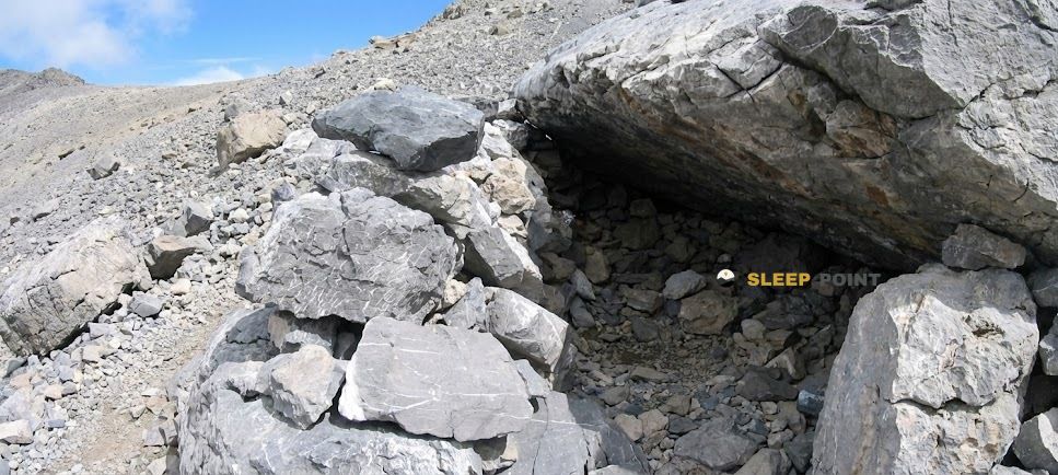
The mountains of vivac, camino brecha rolando, fanlo, sobrarbe, huesca, aragón, españa hide essential places like the Vivac refuge. Situated at an elevation of 2251 meters, it offers protection and rest. Its exact coordinates are 42.662, 0.019.

See more
See more
Usuario

Lucas Martinez

Premium user

Live weather: Vivac

With 83% cloud coverage, the Vivac shelter reports 5.4°C and a feels-like temperature of 3.1°C. Breeze at 1.3 km/h with possible gusts of 6.1 km/h. The freezing altitude is at 4350 m and the maximum will reach 8.6°C.
Temperature

5.4°C

Feels like: 3.1°C
Wind

1.3 km/h

Gusts: 6.1 km/h
Freezing level 0°

4350 m

Snow line
Sky & UV

UV 0

Clouds: 83%

Next 48 hours evolution

7-day forecast

04/06
8.6° 2.9°
5.9 mm 27.5 km/h UV máx: 5.7
06:23 21:33
05/06
8.6° -0°
0 mm 18.4 km/h UV máx: 8.1
06:23 21:33
06/06
10.4° 1.6°
0 mm 6.6 km/h UV máx: 7.7
06:22 21:34
07/06
12° 2.9°
0 mm 9 km/h UV máx: 8.1
06:22 21:35
08/06
17.2° 6.5°
0 mm 16.2 km/h UV máx: 8.25
06:22 21:35
09/06
14.1° 6.9°
1.8 mm 10.9 km/h UV máx: 7.85
06:21 21:36
10/06
15.6° 6.6°
0 mm 11.9 km/h UV máx: 7.9
06:21 21:37

Before counting on it, it is appropriate to plan autonomy

This vivac is located in the environment of the Rolando's gap in the field of Fanlo , Sobrarbe, inside the Lost Mount . At 2251 meters, it fits better on a long mountain day or on a journey than on an improvised exit. By location, it is of particular interest to those who need to fail effort in mountain terrain, link itineraries between sides or gain a sober base to move near the major summits of the sector.

The mental map of the area is clear: to the immediate environment there are very strong references of the central Pyrenees, with Lost Mount a short distance in a straight line and the Marboré Cylinder within the same alpine frame. The connection with the Cirque de Gavarnie , which makes sense to the vivac as a point of passage rather than as a destiny in itself. For those who follow the HRP or value variants by the gap, can serve to divide a demanding stage, although it is appropriate to measure well if it compensates for deviating from the main itinerary according to the state of forces, weather and load.

Access and movement through this area call for experience in stony and time-changing terrain. There is no data here for indoor equipment or services, so the practical reading is simple: to put it as basic support and not as a shelter with comforts. That difference matters a lot if it is used as a basis for trying nearby summits or to channel a journey between hills and shelters around.

In logistics, the most useful data is the presence of a source at about 350 meters. It is still prudent to confirm flow and conditions before depending on it, because in mountain the actual availability may vary. If you ask for night or step at this point, you should reach with margin, water reserve and alternative plan, especially on days coming from long routes such as the rise to Monte Perdido by the gap or the links to Gavarnie.

Hiking routes from the refuge

HRP

HRP Étape 16

↔ Variable distance
Local

Cirque de Gavarnie

↔ Variable distance
Local

Pic de la Pahule

↔ Variable distance
Local

Mont Perdu par la brèche de Roland

↔ Variable distance
Local

Cabane des Soldats

↔ Variable distance
Local

Refuge des Espugeuttes et Pimené

↔ Variable distance
Local

Refuge de la Brèche de Roland

↔ Variable distance
Local

Brèche de Roland et Taillon

↔ Variable distance

Nearby peaks

Grand Astazou

3071 m
Lat: 42.7025 Lon: 0.0237

Punta de Treserols / Monte Perdido

3349 m
Lat: 42.6755 Lon: 0.0344

Mallo de Marmorés / Cilindro de Marboré

3325 m
Lat: 42.6848 Lon: 0.0239

Le Casque du Marboré

3011 m
Lat: 42.6878 Lon: -0.0268

Punta Arrablo / Punta Alta de Sierra Custodia

2792 m
Lat: 42.6625 Lon: 0.0364

Punda dero Espaldador

3073 m
Lat: 42.6853 Lon: 0.0003

Pico Inferior de Añisclo / O Zucón

2802 m
Lat: 42.6513 Lon: 0.0792

Petit Astazou

3015 m
Lat: 42.7019 Lon: 0.0145

Nearby water fountains

Fuente

352 m
Lat: 42.7019 Lon: 0.0145

Fuente

3.23 Km
Lat: 42.7019 Lon: 0.0145

Fuente

4.88 Km
Lat: 42.7019 Lon: 0.0145

Fuente

5.33 Km
Lat: 42.7019 Lon: 0.0145

Fuente

5.63 Km
Lat: 42.7019 Lon: 0.0145

Fuente

6.44 Km
Lat: 42.7019 Lon: 0.0145

Fuente

6.52 Km
Lat: 42.7019 Lon: 0.0145

Fuente

6.55 Km
Lat: 42.7019 Lon: 0.0145
FAQ

Frequently asked questions

Pregunta frecuente
At what exact altitude is the Vivac refuge located?
The Vivac refuge is located at an altitude of 2251 meters above sea level, in the natural surroundings of vivac, camino brecha rolando, fanlo, sobrarbe, huesca, aragón, españa.
Pregunta frecuente
What are the GPS coordinates of the Vivac refuge?
To locate the Vivac refuge on your GPS or map, use the following coordinates: Latitude 42.662 and Longitude 0.019.
Pregunta frecuente
Is it necessary to carry a GPS to reach the Vivac refuge?
It is always highly recommended to carry a GPS device, a route track, or a topographic map in the mountains. You can use the coordinates 42.662, 0.019 to locate this refuge precisely.
More areas

Other areas

Collaborative

Together we improve

image

Send your photos

You can upload photos of shelters and update their status so other users know if they can go there.

Get started
Get started
image

Rate the shelter

Leave your comments to rate the shelter’s condition. In the mountains, we look after each other.

Get started
Get started
image

Add new ones

Did we miss any? Publish the shelters you know so everyone can use them.

Get started
Get started
Download for free from the Apple App Store and Play Store.

Download the app and start looking for the shelter of your next adventure

Aplicación móvil para encontrar refugios de montaña donde dormir
Aplicación móvil para encontrar refugios de montaña donde dormir.
Mapa interactivo de refugios de montaña en los Pirineos dentro de la app
Mapa de refugios de montaña para senderismo y trekking en la app.
Pantalla con información de refugio de montaña con altitud capacidad y servicios
Pantalla con información de refugio de montaña con altitud capacidad y servicios.
Detalles de refugio de montaña con servicios y meteorología en aplicación móvil
Detalles de refugio de montaña con servicios y meteorología en aplicación móvil.
Aplicación para explorar refugios de montaña mediante mapa interactivo
Aplicación para explorar refugios de montaña mediante mapa interactivo.
Ficha completa de refugio de montaña con opiniones y servicios
Ficha completa de refugio de montaña con opiniones y servicios.
Información detallada de refugio en app para montañeros
Información detallada de refugio en app para montañeros.
Listado de refugios de montaña para senderismo y trekking
Listado de refugios de montaña para senderismo y trekking.
Explorar refugios de montaña desde una aplicación móvil
Explorar refugios de montaña desde una aplicación móvil.