Mountain refuge Refugio del Lanchón
We have it listed in the app!
We have it listed in the app!
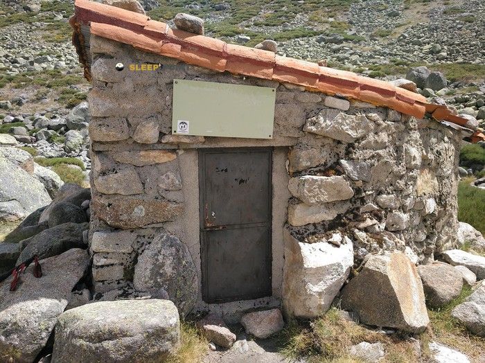

If you are planning a route through refugio del lanchón, bohoyo, Ávila, castilla y león, 05690, españa, the Refugio del Lanchón refuge is a must-stop. Located at 1714 m above sea level, it offers hikers and climbers a safe place to regain strength. Save its coordinates (40.269, -5.371) in your GPS to stay on course during your journey.
9.7°C
Feels like: 7.5°C12.3 km/h
Gusts: 42.5 km/h4560 m
Snow lineUV 0
Clouds: 17% 0 mm
0 mm
 18.7 km/h
 UV máx: 8.3
 06:52
06:52
 21:46
0 mm
17.1 km/h
UV máx: 8.35
06:52
21:47
0 mm
14.5 km/h
UV máx: 8.2
06:52
21:48
0 mm
15.5 km/h
UV máx: 8.3
06:52
21:48
0 mm
18.5 km/h
UV máx: 8.35
06:51
21:49
0 mm
16 km/h
UV máx: 7.95
06:51
21:49
0 mm
15.9 km/h
UV máx: 8
06:51
21:50
21:46
0 mm
17.1 km/h
UV máx: 8.35
06:52
21:47
0 mm
14.5 km/h
UV máx: 8.2
06:52
21:48
0 mm
15.5 km/h
UV máx: 8.3
06:52
21:48
0 mm
18.5 km/h
UV máx: 8.35
06:51
21:49
0 mm
16 km/h
UV máx: 7.95
06:51
21:49
0 mm
15.9 km/h
UV máx: 8
06:51
21:50
At 1714 meters, the relief around this construction becomes austere. The promotion from Hole by the homonymous throat is a progressive advance towards a low-thinning and granite environment, characteristic of this area of the Sierra de Gredos . The Refugio del Lanchón offers a point of protection in a sector where transit decreases, accentuating the sense of isolation from the most crowded routes of the massif. It is imperative to bear in mind that there are no immediate water sources, with the supply points closest to several kilometres away, which requires rigorous weight and consumption planning. The navigation along these slopes requires constant attention, as the changes of slope towards the Canchón de la Cruz They can make the march difficult if the cloud goes down on the cord.
The site is strategic to divide promotion days into the high areas without dependent on an immediate return to the valley. Its proximity to peaks like the Head of the Horcajo allows it to be used as a basis for exploring the northern aspects, connecting with itineraries that are directed towards nearby glacial circles. However, the austerity of installation and climate exposure require adequate technical preparation and complete autonomy. In the absence of services or equipment, the mountaineer must carry everything necessary for overnight and safety. The progression from this point to the upper crests requires release on mountain grounds, where the absence of beamed paths in some sections tests the ability to orientation in a landscape dominated by silence and naked rock.


📏 2 Km
⛰️ 1588 m

📏 2.1 Km
⛰️ 1560 m

📏 3.3 Km
⛰️ 2128 m

📏 3.8 Km
⛰️ 1385 m

📏 4.5 Km
⛰️ 1345 m

📏 5.3 Km
⛰️ 2166 m

📏 6.1 Km
⛰️ 2010 m

📏 6.3 Km
⛰️ 2083 m
Download the app and start looking for the shelter of your next adventure


Find a place to sleep before night falls.


