Mountain refuge Refugio de Malacatones
We have it listed in the app!
We have it listed in the app!


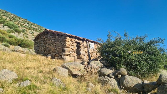
Discover the vastness of refugio de la mina, camino de las cuevas, navalonguilla, Ávila, castilla y león, 05697, españa by spending the night at the Refugio de Malacatones refuge. It sits at 1698 meters, offering a unique balcony over the natural landscape. Find it on the map at latitude 40.213 and longitude -5.556.
12.3°C
Feels like: 10.8°C9.1 km/h
Gusts: 40 km/h4670 m
Snow lineUV 0
Clouds: 1% 0 mm
0 mm
 17.7 km/h
 UV máx: 8.1
 06:53
06:53
 21:47
0 mm
17.7 km/h
UV máx: 8.35
06:53
21:48
0 mm
15.1 km/h
UV máx: 7.6
06:53
21:48
0 mm
16.5 km/h
UV máx: 8.2
06:52
21:49
0 mm
14.8 km/h
UV máx: 8.45
06:52
21:49
0 mm
9 km/h
UV máx: 7.95
06:52
21:50
0 mm
13 km/h
UV máx: 7.95
06:52
21:51
21:47
0 mm
17.7 km/h
UV máx: 8.35
06:53
21:48
0 mm
15.1 km/h
UV máx: 7.6
06:53
21:48
0 mm
16.5 km/h
UV máx: 8.2
06:52
21:49
0 mm
14.8 km/h
UV máx: 8.45
06:52
21:49
0 mm
9 km/h
UV máx: 7.95
06:52
21:50
0 mm
13 km/h
UV máx: 7.95
06:52
21:51
Without reliable water sources in the immediate vicinity, the stay in the Malachons Refuge requires a rigorous forecast of water load from the start of the activity, as the nearest supply points are several kilometres away. Located in the municipal term of Navalonguilla , on the abulian side of the Sierra de Gredos, this shelter is located at 1698 meters of altitude, integrating itself into a high mountain environment where the land begins to gain verticality towards the great Western massizos. Its location next to the path of the caves places it as a tactical resource for those who explore the network of local trails, although its isolation and the absence of confirmed services suggest a preferential use as emergency coat or technical rest point during days of approach to the higher and remote areas of the central system.
The relief surrounding the area is marked by the proximity of imposing glacial structures, such as the circus of Devil's corral and summits of great importance that far exceed two thousand meters of altitude. From this strategic position, the mountain can direct its objectives towards ascension of remarkable physical demand such as the Alto del Corral del Diablo or the summit of La Covacha with its 2395 meters represents the maximum elevation of this western sector of the saw. Connectivity with signposted itineraries, including the Senda de la Laguna de la Nava or the Senda de la Laguna de los Knights, makes it possible to draw crossing routes linking deep valleys and throats of great geomorphological value. However, the hardness of the granite terrain and the usual weather severity in these areas make this shelter a resource valued mainly by profiles with autonomy, serving as support in the transit to the Pico del Mosquito, the Pelado or the Canchal de los Ballesteros.


📏 1.4 Km
⛰️ 1542 m

📏 3.9 Km
⛰️ 1780 m

📏 4.6 Km
⛰️ 1794 m

📏 4.8 Km
⛰️ 1504 m
📏 5.7 Km
⛰️ 1416 m

📏 6.2 Km
⛰️ 1627 m

📏 7.8 Km
⛰️ 1496 m

📏 10.6 Km
⛰️ 2083 m
Download the app and start looking for the shelter of your next adventure


Find a place to sleep before night falls.


